
River Avon, Bristol facts for kids
Quick facts for kids River Avon |
|
|---|---|

The Avon Gorge and Clifton Suspension Bridge
|
|
.png)
Course of the Avon
|
|
| Other name(s) | Bristol Avon |
| Country | England |
| Counties of England | Gloucestershire, Wiltshire, Somerset, Bristol |
| Towns/cities | Chippenham, Melksham, Bradford on Avon, Bath, Bristol |
| Physical characteristics | |
| Main source | Didmarton Gloucestershire, England 120 m (390 ft) 51°31′49″N 2°16′26″W / 51.53028°N 2.27389°W |
| River mouth | Severn Estuary Avonmouth, Bristol, West of England, England 51°30′22″N 2°43′06″W / 51.50611°N 2.71833°W |
| Length | 134 km (83 mi) |
| Basin features | |
| Basin size | 2,308 km2 (891 sq mi) |
| Tributaries |
|
| River system | River Severn |
The River Avon is a river in the southwest of England. To tell it apart from other rivers with the same name, it's often called the Bristol Avon. The word 'Avon' comes from an old Welsh word meaning 'river'. So, its name literally means "river river"!
The Avon starts north of Acton Turville in South Gloucestershire. It then flows through Wiltshire and into Somerset. From the city of Bath to the Severn Estuary near Bristol, the river is wide enough for boats. This part is known as the Avon Navigation.
The River Avon is the 19th longest river in the United Kingdom. It stretches about 83 miles (134 km). However, its source and mouth are only 19 miles (31 km) apart in a straight line. The area of land that drains into the river, called its catchment area, is about 2,220 square kilometres (857 sq mi).
Contents
Where Does the River Avon Start and Flow?
The River Avon begins on the southern edge of the Cotswolds hills. Its source is at Didmarton in Gloucestershire. A special plaque at Joyce's Pool marks this starting point.
The river first flows southeast into Wiltshire. At Sherston, it is joined by the Luckington Brook. This smaller stream collects water from the area around the Badminton House estate.
Meeting Other Rivers
From Sherston, the Avon flows east to Malmesbury. Here, it meets its first big tributary, the Tetbury Avon. This river starts near Tetbury in Gloucestershire. Locals sometimes call it the Ingleburn, which means 'English river' in Old English. The two rivers flow around a rocky hill, almost making an island for the old town of Malmesbury.
After these rivers join, the Avon turns southeast away from the Cotswolds. It then quickly flows south into the clay Dauntsey Vale. Here, the River Marden joins it. The river then reaches Chippenham, the biggest town so far.
Through Towns and Historic Bridges
The wide valley is now called the Avon Vale. The river continues past Lacock to Melksham. Then it turns northwest through Bradford-on-Avon. This town got its name from a "Broad-Ford" or wide river crossing. A Norman bridge, built in the 17th century, still stands here today.
The Avon Valley between Bradford-on-Avon and Bath is special. You can see four types of transport here: road, rail, river, and canal. The river flows under the Avoncliff Aqueduct and Dundas Aqueduct. These aqueducts carry the Kennet and Avon Canal over the river.
At Freshford, the Somerset River Frome joins the Avon. The Avoncliff Aqueduct was built between 1797 and 1801. It has three arches and is 110 yards (100 m) long. The Dundas Aqueduct was built by the same team and finished in 1805. It is 150 yards (137 m) long with three arches made of Bath Stone.
Pumping Stations and Famous Bridges

The river then flows past Claverton Pumping Station. This station uses the river's power to pump water into the canal. Water from the river is sent down a special channel to the pump house. There, a large water wheel, 24 feet (7.3 m) wide, turns five times a minute. This wheel powers pumps that lift 50 gallons (227 litres) of water per stroke into the canal.

The Avon flows through Bathford, where the Bybrook River joins it. It then passes under the Bathampton Toll Bridge at Bathampton. In Bath, the Lam Brook joins the Avon. The river then goes under Cleveland Bridge and Pulteney Bridge, and over a weir.
Cleveland Bridge was built in 1826. It helped the city of Bath grow on the south side of the river. Pulteney Bridge was finished in 1773. It is one of only four bridges in the world with shops built across its entire length on both sides! Floods in 1799 and 1800 damaged the bridge, but it was rebuilt.
About 700 metres (2,300 ft) below Pulteney weir, the Kennet and Avon Canal connects to the river. This canal, along with the Kennet Navigation, links Bristol to London by water. From this point downstream, the river is known as the Avon Navigation.
How Boats Use the River Avon
The Avon is navigable for boats from Bath to the Severn Estuary. This part of the river is called the Avon Navigation. It was made navigable between 1724 and 1727.
Locks and Harbours
The river uses six locks and weirs to help boats travel along its course. From Bath to Netham Lock in Bristol, it's about 12 miles (19 km).
In Bath, the river passes under bridges like the Midland Bridge. This bridge was built for trains. Weston Lock is on the edge of Bath. A man-made channel, the Weston Cut, was opened in 1727 for boats to reach this lock.

Further downstream are Kelston Lock and Saltford Lock. Near Saltford Lock, you can see the remains of the Kelston Brass Mill. This mill used the river's power until 1925. Swineford Lock was once a busy area for brass and copper industries. Keynsham Lock opened in 1727. The River Chew joins the Avon just above this lock. Hanham Lock is the last lock before the river becomes tidal.
Netham Lock in Bristol is where boats enter Bristol's floating harbour. This harbour was created by diverting the river's original course. A new channel, the New Cut, was dug between 1804 and 1809. This system allowed ships to stay afloat in the harbour even when the tide went out. Netham Lock also helps protect Bristol from floods.
The Avon Gorge and Docks

.jpg)
In central Bristol, the river is tidal. It flows through the deep Avon Gorge. This gorge is famous for the Clifton Suspension Bridge, designed by Isambard Kingdom Brunel. At high tide, large ships can sail through the gorge. But at low tide, it becomes a muddy channel.
Before reaching the sea, the River Trym joins the Avon at Sea Mills. This was once a Roman port. The river then passes under the Avonmouth Bridge, which carries the M5 motorway.
The Avon serves two big dock areas near its mouth. The Royal Portbury Dock is a major port for importing cars. It has the largest entrance lock of any UK port. The Avonmouth Docks are important for chilled foods like fruit and vegetables. These docks are part of the Port of Bristol.
River Health and Wildlife
The River Avon's water quality is monitored regularly. The river is divided into different areas for this purpose. Pollution from wastewater and farming can affect the water. However, efforts are being made to improve the river's health.
Amazing Plants and Animals
The river is a special place for dragonflies. Rare species like the scarce chaser and white-legged damselfly live here. You can also find the red-eyed damselfly. Many aquatic plants, like Loddon pondweed, also grow in the river.
Some parts of the river are protected as Sites of Special Scientific Interest (SSSIs). These areas are important for their geology and wildlife. For example, the Kellaways – West Tytherton site has many fossils of ancient sea creatures. The Newton St Loe SSSI has fossils of mammoths and horses.
The Avon Gorge is an SSSI because it has rare plants and animals. Some plant species, like the Bristol and Wilmotts's whitebeams, are found only in this gorge. Other rare plants include Bristol rock-cress and Bristol onion.
The tidal parts of the River Avon are home to many waterbirds. Over 60 species have been seen here, including many types of shorebirds and gulls.
Who Looks After the River?
Different groups have been in charge of the River Avon over the years. Today, the Environment Agency helps manage the river's health and environment.
The Bristol Port Company is responsible for navigation in the lower river, from Avonmouth to Hotwells. Bristol City Council manages navigation within Bristol's floating harbour.
A Look Back at the River's History
The River Avon has been important for a long time. In the Iron Age, it may have formed borders between different tribes. After the Romans arrived, it became a boundary between kingdoms.
In the 13th century, the river was navigable from Bristol to Bath. But mills built on the river later blocked boat traffic. The city of Bath is built on the river's floodplain. The river used to have many small streams and swamps, but weirs were built to create a single channel. This helped control flooding, which used to happen often in Bath.
The Bristol Avon Navigation was built between 1724 and 1727. This allowed boats to travel from the Kennet and Avon Canal to the Bristol Channel. The first cargo arrived in Bath in December 1727. Today, the Canal & River Trust manages this navigation.
.jpg)
The Avon Gorge has always been a key transport route. It carries the river, major roads, and two railways. The Bristol Channel has a very high tidal range, meaning the water level changes a lot between high and low tide. This makes the gorge tricky to navigate. Several ships have run aground here over the years.
The Avon has flooded many times throughout history. Floods in 1799 and 1800 damaged Pulteney Bridge. Some areas along the river are designed to be floodplains. This means they can hold extra water during floods to protect towns. As weather patterns change, more steps might be needed to protect people from flooding.
Places to See Along the River Avon
| Point | Coordinates (Links to map resources) |
OS Grid Ref | Notes |
|---|---|---|---|
| Source | 51°35′13″N 2°15′18″W / 51.587°N 2.255°W | ST811813 | Didmarton |
| Sherston | 51°34′23″N 2°12′47″W / 51.573°N 2.213°W | ST853860 | Sherston |
| Tetbury Avon confluence | 51°34′55″N 2°05′31″W / 51.582°N 2.092°W | ST936870 | Malmesbury |
| M4 Motorway | 51°30′50″N 2°04′26″W / 51.514°N 2.074°W | ST949795 | M4 Bridge |
| River Marden confluence | 51°27′58″N 2°05′38″W / 51.466°N 2.094°W | ST935741 | Dauntsey Vale |
| Chippenham | 51°27′32″N 2°07′01″W / 51.459°N 2.117°W | ST919733 | Chippenham |
| National Trust village | 51°24′43″N 2°07′08″W / 51.412°N 2.119°W | ST917682 | Lacock |
| Melksham | 51°22′26″N 2°08′20″W / 51.374°N 2.139°W | ST904638 | Melksham |
| Norman bridge | 51°20′49″N 2°15′07″W / 51.347°N 2.252°W | ST825609 | Bradford on Avon |
| Avoncliff Aqueduct | 51°20′17″N 2°16′55″W / 51.338°N 2.282°W | ST804599 | Avoncliff |
| River Frome, Somerset confluence | 51°21′25″N 2°18′36″W / 51.357°N 2.310°W | ST784620 | Freshford |
| Dundas Aqueduct | 51°21′43″N 2°18′40″W / 51.362°N 2.311°W | ST783626 | Dundas Aqueduct |
| Claverton Pumping Station | 51°22′41″N 2°18′11″W / 51.378°N 2.303°W | ST790644 | Claverton |
| Bathford bridge & Bybrook River confluence | 51°24′04″N 2°18′29″W / 51.401°N 2.308°W | ST786669 | Bathford |
| Toll bridge | 51°23′46″N 2°19′16″W / 51.396°N 2.321°W | ST777664 | Bathampton |
| Cleveland Bridge | 51°23′20″N 2°21′25″W / 51.389°N 2.357°W | ST752657 | Cleveland Bridge |
| Pulteney Bridge and weir | 51°22′59″N 2°21′32″W / 51.383°N 2.359°W | ST751650 | Pulteney Bridge |
| Kennet and Avon Canal confluence | 51°22′37″N 2°21′11″W / 51.377°N 2.353°W | ST755643 | Bath Locks |
| Weston Lock | 51°22′59″N 2°23′53″W / 51.383°N 2.398°W | ST723649 | Newbridge |
| Kelston Lock | 51°24′04″N 2°27′00″W / 51.401°N 2.450°W | ST687669 | Kelston |
| Brass Mill at Saltford Lock | 51°24′36″N 2°26′38″W / 51.410°N 2.444°W | ST691679 | Saltford |
| Swineford Lock | 51°25′05″N 2°26′46″W / 51.418°N 2.446°W | ST691689 | Swineford |
| Keynsham Lock & River Chew confluence | 51°25′12″N 2°29′35″W / 51.420°N 2.493°W | ST657691 | Keynsham |
| Hanham Lock | 51°25′41″N 2°30′40″W / 51.428°N 2.511°W | ST645700 | Hanham |
| Brislington Brook confluence | 51°27′14″N 2°32′31″W / 51.454°N 2.542°W | ST623729 | Brislington |
| Start of new Cut and Floating Harbour | 51°27′04″N 2°33′07″W / 51.451°N 2.552°W | ST617726 | Netham Lock |
| Bristol Harbour | 51°26′49″N 2°36′04″W / 51.447°N 2.601°W | ST582722 | Bristol |
| Clifton Suspension Bridge | 51°27′18″N 2°37′44″W / 51.455°N 2.629°W | ST563731 | Avon Gorge |
| River Trym confluence | 51°28′48″N 2°39′07″W / 51.480°N 2.652°W | ST548759 | Sea Mills |
| Avonmouth Bridge | 51°29′20″N 2°41′38″W / 51.489°N 2.694°W | ST519769 | Avonmouth Bridge |
| Mouth | 51°30′11″N 2°42′00″W / 51.503°N 2.700°W | ST515785 | Royal Portbury Dock and Avonmouth Docks at Avonmouth |
Images for kids
-
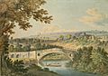
New Bridge, Bath, painted in 1806.
-
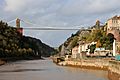
The Avon Gorge and the famous Clifton Suspension Bridge.


See also
 In Spanish: Río Avon (Brístol) para niños
