River Frome, Bristol facts for kids
Quick facts for kids Frome |
|
|---|---|

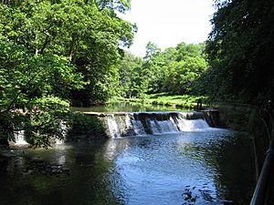
The river at Snuff Mills
|
|

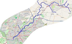
Map of the River Frome and tributaries in Bristol and South Gloucestershire
|
|
| Other name(s) | Froom |
| Country | England |
| Region | West Country |
| District | South Gloucestershire, Bristol |
| City | Bristol |
| Physical characteristics | |
| Main source | Dodington Park Chipping Sodbury, South Gloucestershire, England 515 ft (157 m) 51°30′39″N 2°20′39″W / 51.510726°N 2.344268°W |
| River mouth | Floating Harbour, Bristol Bristol, England 33 ft (10 m) 51°26′56″N 2°35′54″W / 51.4489°N 2.5983°W |
| Length | 20 mi (32 km), south west |
| Basin features | |
| Tributaries |
|
| River system | Bristol Avon |
The River Frome, also called the Froom, is a river in England. It starts in Dodington Park in South Gloucestershire. From there, it flows southwest through the city of Bristol. The Frome eventually joins the River Avon in Bristol's Floating Harbour.
The River Frome is about 20 miles (32 km) long. Its name, Frome, means 'fair, fine, or brisk' in an old British Celtic language. You might hear people in east Bristol call it the Danny.
Like many rivers in cities, the Frome has faced challenges with pollution. However, many parts of the river flow through beautiful parks and nature areas. These spots are home to lots of different wildlife. In the past, the river's strong current powered many watermills. The area near its mouth was also important for building ships. As Bristol grew, flooding became a big problem. To fix this, special storm drains and diversions were built.
The River Frome: Bristol's Hidden Waterway
The River Frome is about 20 miles (32 km) long. It begins in the countryside of Dodington Park in the Cotswolds. This area is in South Gloucestershire.
Where Does the Frome Start and Go?
The river first flows through Chipping Sodbury and Yate. Along the way, smaller streams like the Nibley brook and Mayshill brook join it. The Frome then turns south towards Frampton Cotterell, where the Ladden brook adds its water.
Continuing south, the Frome passes between Yate and Winterbourne. It crosses Winterbourne Down before the Folly brook joins it. The Bradley brook then flows into the Frome near Hambrook. After this, the river goes under the M4 motorway. The Stoke brook also joins it near Bromley Heath.
After passing under the A4174 road, the Frome enters the city area. It flows between Frenchay and Downend. The river then turns southwest and enters Oldbury Court estate, which is a city park. Here, two different Fishponds brooks join the Frome.
The river then passes Snuff Mills and flows through a deep valley at Stapleton. It continues past Eastville Park, where it used to fill a boating lake. After this, the Frome goes under the M32 motorway. It then flows underground into a large culvert near Baptist Mills. Other streams, like Coombe brook and Horfield brook, join it underground.
A small part of the river can be seen in St Jude's. After that, it flows completely underground beneath streets like Broad Weir and Rupert Street. The main flow of the river is now directed through a special channel called Mylne's Culvert. This culvert takes the water under the city to the River Avon. The section of the river under The Centre acts as a backup channel for when there's too much water.
Exploring the River by Boat
Some parts of the River Frome can be explored by canoe or kayak. You can paddle from Damsons Bridge to Snuff Mills. Sometimes, you might need to carry your boat around certain spots. It's also possible to start your journey from Moorend Bridge or Frenchay Bridge.
A Look Back: The Frome's History

Between Frenchay and Stapleton, the river drops quite a bit, about 50 feet (15 m). This drop was perfect for powering watermills. Many mills were built along this stretch to grind corn and do other work. Today, you can still see a water wheel at Snuff Mills. The old mill buildings of Cleeve Mill are now private homes.
How the River Changed Bristol
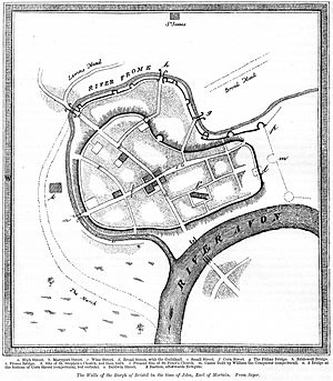
The Frome's path has changed a lot over time. Originally, it flowed differently through Bristol. The narrow strip of land between the Frome and the Avon was a great place for the early settlement of Bristol to grow. Around 1110, when Robert, 1st Earl of Gloucester rebuilt Bristol Castle, a part of the Frome was used to create a moat around the castle. This meant the town and castle were completely surrounded by water for protection.
In the mid-1200s, Bristol's harbour became very busy. So, people decided to dig a new path for the Frome. This new path, called "Deep Ditch," went through marshland and joined the Avon in a new spot. This new mouth of the Frome is known as St Augustine's Trench or Reach.
In 1809, the Floating Harbour was built. This meant the Avon and Frome were no longer affected by tides in the city centre. However, the Frome was also being used as a sewer, and without the tides to wash it clean, it became a health problem. So, in 1828, the main flow of the river was sent through Mylne's Culvert. This culvert goes under the city and joins the tidal Avon in a different area.
Over the years, more and more of the Frome was covered up. By the late 1800s and early 1900s, large sections of the river in the city centre were put into underground culverts. Today, streets like Rupert Street and Broad Weir run over these hidden parts of the river.
Building Ships on the Frome
For many centuries, ships were built along the River Frome. Docks were located on Narrow Quay. In the 1600s, Francis Baylie built warships there. Later, more docks were built, like Tombs' Dock (also known as Green's Dock) in 1760. Sydenham Teast also built docks in 1790. The last shipbuilding company on the Frome closed in 1883.
What Does "Frome" Mean?
The name Frome comes from an old British Celtic word. It means 'fair, fine, or brisk'. It's important not to confuse it with other rivers in southwest England that have the same name. The old spelling, Froom, is still sometimes used. This is also how the name of the river is pronounced, like the word "broom."
In the 1800s and 1900s, people in East Bristol started calling the River Frome the Danny. No one is quite sure why. Some people think it might be a nickname from the Blue Danube Waltz song. Others think it came from an Australian slang word.
Dealing with Floods: Keeping Bristol Safe
The River Frome used to flood often in Bristol. To help control this, a large underground tunnel called the Northern Stormwater Interceptor was built. It runs from Eastville Sluices to the River Avon.
In St Jude's, the river goes into an underground culvert. It only comes out into what Bristolians call The Centre when there is a risk of flooding. Otherwise, the water flows through Mylne's Culvert to the River Avon. There are also three other flood relief tunnels under Castle Park in central Bristol. These tunnels help carry extra water into the Floating Harbour during heavy rains.
Bristol has experienced several major floods over the years. These included floods in St Werburghs and Wellington Road in 1882, and in Eastville and Broadmead in 1936 and 1937. Even today, the Broadmead area can still be at risk of flooding during very bad weather.
Explore the Frome Valley Walkway
The Frome Valley Walkway is a public footpath that follows the river for about 18 miles (29 km). It runs almost the entire length of the Frome, from Old Sodbury to Bristol. You can find a guide pamphlet to help you explore it.
This walkway was created by a group of local councils, environmental groups, and wildlife organizations. These groups include the Avon Biodiversity Partnership and the Avon Wildlife Trust. They often hold events to clear away unwanted plants and offer guided walks.
Wildlife Along the River Frome
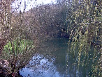
The Frome valley is home to many different kinds of wildlife and plants. The river flows through or near several nature reserves and parks. These include Goose Green fields, Chill Wood, Cleeve Valley, Oldbury Court park, and Eastville Park.
You might spot grey wagtails, dippers, and different types of bats. You can also find wild service trees growing here. The river used to be home to one of the last groups of the endangered native white-clawed crayfish in the Bristol area. Sadly, they disappeared from the river in 2008.
 | Valerie Thomas |
 | Frederick McKinley Jones |
 | George Edward Alcorn Jr. |
 | Thomas Mensah |


