
Yate facts for kids
Quick facts for kids Yate |
|
|---|---|
|
Clockwise from top: Yate shopping centre, Poole Court, Stanshawes Court, Townscape and St Mary's Church |
|

Yate
|
|
| Population | 23,703 (2021 Census) |
| OS grid reference | ST7182 |
| Civil parish |
|
| Unitary authority | |
| Ceremonial county | |
| Region | |
| Country | England |
| Sovereign state | United Kingdom |
| Post town | BRISTOL |
| Postcode district | BS37 |
| Dialling code | 01454 |
| Police | Avon and Somerset |
| Fire | Avon |
| Ambulance | Great Western |
| EU Parliament | South West England |
| UK Parliament |
|


Yate is a lively town located in South Gloucestershire, England. It sits near the beautiful Cotswold Hills. Yate is about 12 miles (19 km) northeast of the big city of Bristol. It is also about 12 miles (19 km) from the historic city of Bath.
Yate was once a small village. It started growing into a town in the 1950s. By 2011, about 21,789 people lived in Yate. The nearby market town of Chipping Sodbury is right next to Yate. If you count the areas around Yate, the total population is estimated to be around 35,000 people.
Contents
Where is Yate Located?
Yate is found northeast of Bristol. Bristol is about 12 miles (19 km) away by road. Yate is surrounded by lots of open countryside. It is also located southwest of the Cotswolds, a famous area of hills. The main road that goes through the center of Yate is the A432.
A Look Back at Yate's History

The first time Yate was mentioned in history was around AD 770. This was when a religious building existed there. Yate is also written about in the Domesday Book from 1086. The name "Yate" comes from an old English word, giete or gete. This word means 'a gateway into a forest area'.
Long ago, during the Anglo-Saxon period and medieval times, much of this part of South Gloucestershire was covered by forests. Over many centuries, people cleared the land to make farms.
The town's main church, St Mary's, was built during Norman times. It was changed in the 1400s and fixed up a lot in 1970. St Mary's Primary School is next to the churchyard. It was built where an old poorhouse used to be.
How the Railway Changed Yate
Yate really started to grow when its railway station opened in 1844. This station was part of the Bristol and Gloucester Railway. Station Road became the main street. Markets for cattle and farm goods were held there. Many businesses also started up along this road.
The Yate railway station closed in 1965. This was due to changes in the railway system. But it reopened in May 1989. An old engine shed, built by the famous engineer Brunel, is still kept nearby.
Yate's Growth and Development
Yate began to grow a lot in the early 1920s. This was when the Moorland Road housing estates were built. They were close to the Parnall aeroplane factory. In the 1950s, the Ridge housing estate was built. The land between these areas was still being mined for a mineral called celestine. So, houses could not be built there until the mining stopped.
In the 1960s, Yate was chosen as a special development area. This started a big building boom. A new town was created with a large shopping area. It also got sports and leisure facilities, along with public buildings.
By the 1960s, the celestine mining stopped in the Stanshawes area. More houses were built, especially in the south. Many of these homes were planned using the Radburn model. This design created areas without cars at the front of houses. Instead, there were green spaces and paths. This model was used until the late 1980s and early 1990s. Then, planners went back to traditional street designs for new areas like Brimsham Park.
When a secondary school was built in the late 1970s, it was supposed to be called Brinsham Green School. This name came from Brinsham Lane nearby. But because of a spelling mistake, it was actually called Brimsham Green School. The town kept growing in the 1990s and 2000s. More houses were built in North Yate. This new area also used the name Brimsham. Locals often call it Brimsham Park.
Yate's Wartime Railway Yard
During the Second World War, a special railway yard was built in Yate. It was for the United States Army. This yard helped gather troops and supplies before D-Day. Two big storage sheds from that time stayed on the site until 2008.
After the war, the Royal Navy took over the site. It became known as the Sea Transport Stores Depot. Later, the Highways Agency used it. The sheds were taken down for new development. Experts are now studying the site to learn more about its military history.
How Yate is Governed
Yate is represented in the UK Parliament. It is part of the Thornbury and Yate area.

Historically, Yate was part of Gloucestershire. In 1974, it became part of a new area called Avon. When Avon was ended in 1996, Yate joined South Gloucestershire. It also became part of the ceremonial county of Gloucestershire again. The Yate Town Council manages local services. You can find more information on their website.
Yate's Industries and Resources
Before the Second World War, Yate had an aircraft factory called Parnall. It even had a grass airfield. During the war, Parnall made gun turrets for planes. Sadly, some people died when the factory was attacked by the Luftwaffe in 1941.
After the war, the Parnall factory started making things for homes. It became famous for its washing machines. In 1958, Parnall joined with another company and became Jackson. They made cookers. Now, Jackson is part of Indesit, and the name Jackson is no longer used.
Another large factory in Yate was Newman's of Bristol. It was on Station Road from 1932 until the 1980s. In the 1960s, over 1,500 people worked there.
Yate has three important natural resources. These are limestone to the east, celestine (or spar) near the town center, and coal to the west.
The need for limestone grew as more roads were built. The demand for coal increased as wood became harder to find. Celestine is a mineral that contains strontium. It was first dug up in the late 1880s. It was first used to refine sugar beet. At one time, Yate produced 95 percent of the world's celestine! Celestine makes flames turn red. This made it important for fireworks, military flares, and tracer bullets. The last time celestine was dug up in Yate was for use during the Vietnam War. The mining company closed in 1994.
Fun Things to Do in Yate

Yate has a skatepark at Peghill. Yate Common on Westerleigh Road is a great place for walking dogs. You can also watch nature, fly kites, and see circuses or fairs there.
The common has a part of an unused dual carriageway road. People call it the "Road to Nowhere." It has even been used for filming TV shows like Casualty. This road was meant to be a bypass. But it was only partly finished in 1974. Finishing the road would have meant building a bridge over the railway. But the money for this was never found.
Yate has several parks and open spaces. The biggest is Kingsgate Park. It has a fun adventure playground for kids. The town also has a community radio station called GLOSS FM. It broadcasts online every day. Twice a year, you can hear it on 87.7 MHz FM. A Cineworld cinema opened in the new Riverside shopping center in April 2016.
The town has a fire station with four fire engines. It also has an ambulance station with six bays.

Building a shopping center with about 100 shops started in the mid-1960s. It was opened by famous people like Patricia Phoenix. Modern art was added, including a "Four Seasons" sculpture and a tall spire. The spire could be seen from far away. It was removed in the early 1990s when the center was updated. Glass roofs were added over the walkways.
More shops were added in the 1980s and 1990s. From the 1980s to the mid-1990s, the shopping center hosted Yate's yearly festival. A celebrity would launch the festival by releasing balloons. In 2006, the owners of the shopping center announced plans to make it bigger and more modern.
Getting Around Yate
Train Travel in Yate
Yate railway station serves the town. It is on the main train line from Bristol to Birmingham. The station is run by Great Western Railway.
Bus Services in Yate
Bus services in Yate are mostly provided by First West of England. Other companies also offer bus routes to and from Yate.
Regular bus services connect Yate to Bristol city center. There are also buses from Yate to Bath, Cribbs Causeway, and other nearby towns. Yate is also served by the WESTlink on-demand bus. This bus service is available Monday through Saturday.
Buses in Yate pick up and drop off at Yate Bus Station. This station is at Yate Shopping Centre. Some bus services also pass by Yate railway station. Yate Park and Ride is on the west side of town. It has services to the town center and to Bristol.
Yate's Twin Towns
Yate has "twin town" friendships with two other places. It is twinned with Bad Salzdetfurth in Germany. It is also twinned with Genieri in Gambia.
Local News and Media
Local news and TV shows for the area come from BBC West and ITV West Country. TV signals are received from the Mendip TV transmitter. Because Yate is close to Wales, you can also sometimes get BBC Wales and ITV Cymru Wales from the Wenvoe TV transmitter.
Local radio stations include BBC Radio Bristol, Heart West, and Smooth Radio Bristol. There is also a community radio station called Thornbury Radio.
Yate's local newspapers are the Evening Post and the Gazette Series.
Sports in Yate
Yate has many sports clubs for different interests.
Athletics
Yate and District Athletic Club is a track-and-field club. It is based at Yate Outdoor Sports Complex (YOSC). The club started in 1983. An eight-lane track was finished in 1988. It was officially opened by Olympian Lynn Davies in 1989. Floodlights were added in 1992.
Cricket
Chipping Sodbury Cricket Club is the closest cricket club to Yate. It offers cricket for men, women, boys, and girls. They play their home games at the Ridings playing fields in Chipping Sodbury.
Football
Yate Town F.C. plays in the Southern League. There is also a ladies' football team, Yate Town Girls/Ladies FC. They play in local leagues. Yate is also home to Yate United Youth F.C. This is the largest local youth-only football club. It started in 1971. They play their home games at Yate Outdoor Sports Complex.
Another large local club is St. Nicholas F.C., also known as St. Nick's. This club has 21 teams, including two ladies' teams and one men's team. They play at The Ridings in Chipping Sodbury. The women's first team, St Nicholas L.F.C., plays in the FA Women's Premier League. They play their home games at Yate Town's ground.
Hockey
Yate Hockey Club has teams for adults and juniors. Their home ground is Yate Outdoor Sports Complex. They share it with Badminton and Pucklechurch Hockey Club.
Rugby
Yate Rugby Football Club was started in 2016. The club plays its home games at Yate Outdoor Sports Complex. Yate RFC plays in the Bristol & District 2 league. In the 2018/19 season, they finished in fourth place. This was their highest league position ever. The club also has a second team called Yate Yaks. They play friendly games and raise money for charity.
Famous People from Yate
- J.K. Rowling, the author of the Harry Potter books, was born in Yate in 1965. She lived in Yate until she was four years old.
- Cole Skuse, born in 1986, is a professional footballer.
Nearby Towns and Villages
 |
Iron Acton | Rangeworthy | Wickwar | |
| Coalpit Heath | Chipping Sodbury | |||
| Ram Hill | Westerleigh | Codrington |
Images for kids
-
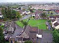
A view of the townscape of Yate.
See also
 In Spanish: Yate (Gloucestershire) para niños
