South Gloucestershire facts for kids
Quick facts for kids
South Gloucestershire
|
|
|---|---|
|
Unitary authority area
|
|

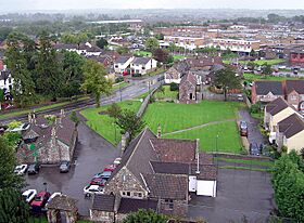
Yate town skyline
|
|

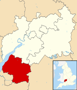
Shown within Gloucestershire
|
|
| Sovereign state | United Kingdom |
| Constituent country | England |
| Region | South West England |
| Ceremonial County | Gloucestershire |
| Combined authority | West of England |
| Admin HQ | Yate |
| Government | |
| • Type | Unitary authority |
| • Body | South Gloucestershire Council |
| Area | |
| • Total | 191.87 sq mi (496.94 km2) |
| Area rank | 92nd (of 326) |
| Population
(2020)
|
|
| • Total | 285,093 |
| • Rank | 50th (of 326) |
| • Density | 1,485.868/sq mi (573.697/km2) |
| Ethnicity (2021) | |
| • Ethnic groups |
List
|
| Religion (2021) | |
| • Religion |
List
46.1% no religion
44.1% Christianity 8.2% other 1.6% Islam |
| Time zone | UTC0 (GMT) |
| • Summer (DST) | UTC+1 (BST) |
| ONS code | 00HD (ONS) E06000025 (GSS) |
| OS grid reference | ST735757 |
| Police | Avon and Somerset |
| Fire | Avon |
| Ambulance | South Western |
South Gloucestershire is a special area in South West England. It is like its own county for local government. It is part of the larger Gloucestershire area.
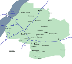
Some of the towns you'll find here include Yate, Chipping Sodbury, Kingswood, Thornbury, Filton, Patchway, and Bradley Stoke. The southern part of South Gloucestershire is very close to the big city of Bristol.
South Gloucestershire was created in 1996. Before that, it was part of a county called Avon. Even though Avon doesn't exist anymore, South Gloucestershire still works with other nearby areas that used to be part of Avon. They share services like the fire department and police. They also work together on plans for transport, roads, and new homes.
Contents
- History of South Gloucestershire
- Population and People in South Gloucestershire
- Economy and Jobs in South Gloucestershire
- Education in South Gloucestershire
- Media and Local News
- Geography and Landscape
- Transport and Travel
- Main Towns and Villages
- Fun Places to Visit
- How Local Government Works
- See also
History of South Gloucestershire
Before 1974, the area we now call South Gloucestershire was part of Gloucestershire. It included smaller areas like Kingswood and Thornbury.
Then, in 1974, a new county called Avon was created. This area became two districts within Avon: Kingswood and Northavon.
In 1996, the county of Avon was removed. That's when South Gloucestershire was formed. It became a "unitary authority," meaning it handles all local government services itself. It borders the city of Bristol and other areas like Bath and North East Somerset, Gloucestershire, and Wiltshire.
Population and People in South Gloucestershire
South Gloucestershire has grown quite a bit over the years!
- In 2001, about 245,641 people lived here.
- By 2011, the population had grown to 262,767.
- The latest estimate from 2021 shows about 290,400 people.
Most people in South Gloucestershire live in towns that are like suburbs of Bristol. These include Yate and its neighbour Chipping Sodbury, and Thornbury. There are also many large villages like Winterbourne and Frampton Cotterell.
Economy and Jobs in South Gloucestershire
South Gloucestershire has many important employers. These are places where a lot of people work.
The local council, which runs the area, employs about 9,500 people. The Ministry of Defence also has a big office here, with 7,000 employees. They handle things like buying equipment for the armed forces.
Other big companies include Airbus (which makes airplanes), Rolls-Royce (known for engines), and the Royal Mail (the postal service). These are mostly in the Filton and Patchway areas.
Many businesses are located in the "North Fringe of Bristol." This area has big shopping centers like Cribbs Causeway. It also has business parks like Aztec West and Almondsbury. Companies like EE (a phone company) and the RAC (a roadside assistance company) have offices here.
Education in South Gloucestershire
South Gloucestershire has many schools for young people.
There are 99 primary schools and 16 secondary schools. After secondary school, students can go to colleges or special centers for further education.
The area is also home to the University of the West of England. This university used to be a polytechnic, which is a type of college that focuses on practical and technical subjects.
In 2008, it was found that secondary schools in South Gloucestershire had a lower absence rate (6.6%) compared to the national average (7.4%). This means more students were in school!
In 2005, the city of Bristol was called one of six "science cities" in the UK. This was because of its strong ties to science and technology. There are plans for a big science park in Emersons Green, which is in South Gloucestershire. This park will help develop more science and technology in the area.
Media and Local News
People in South Gloucestershire can watch TV from BBC West and ITV West Country. These channels broadcast from the Mendip TV transmitter.
There are also several radio stations you can listen to:
BBC Local Radio
- BBC Radio Bristol
Independent Radio
- Heart West
- Greatest Hits Radio Bristol & The South West
- Hits Radio Bristol
- Kiss
Community Radio
- BCfm
- Thornbury Radio (which used to be called Gloss FM)
- Bradley Stoke Radio
Geography and Landscape
The River Severn forms the western edge of South Gloucestershire. Near the river, there's a flat area of land. Further east, you'll find the wide River Frome Valley.
There are also hills, including part of the Cotswolds. The National Trust site of Dyrham Park is also in this area.
The western part of South Gloucestershire is mostly urban, meaning it has many towns and cities. The areas further north are more rural, with countryside and villages. Some green areas have been used for new developments, like the town of Bradley Stoke.
Transport and Travel
It's easy to travel from many parts of South Gloucestershire to nearby cities. You can get to Bristol using roads like the A38 and M32. You can also easily reach Bath.
To the west, you can travel to South Wales and Cardiff using the two Severn bridges. The M5 and M4 motorways connect South Gloucestershire to places like Gloucester and London.
Bristol's northern and eastern ring road, the A4174, also goes through South Gloucestershire. There's also an express bus network called Metrobus that connects Bristol to South Gloucestershire.
The area has a good railway network too. You can take trains directly to many towns and cities across the UK. This includes routes to London, South Wales (through the Severn Tunnel), the South-West, and north to Birmingham. Many train routes meet at Bristol Parkway station in Stoke Gifford. There are six train stations in the district, mostly near the border with Bristol.
Main Towns and Villages
Here are some of the largest towns in South Gloucestershire by population:
- Kingswood 40,734 people
- Bradley Stoke 27,805 people
- Yate 27,603 people
- Thornbury 12,342 people
- Stoke Gifford 11,509 people
- Patchway 10,465 people
- Filton 9,861 people
Other Towns and Villages to Explore
- Abson, Acton Turville, Almondsbury, Alveston, Aust, Awkley
- Badminton, Bagstone, Beach, Bitton, Bridgeyate
- Cadbury Heath, Catbrain, Charfield, Cheswick, Charlton (former village), Charlton Hayes, Chipping Sodbury, Churchend, Coalpit Heath, Codrington, Cold Ashton, Compton Greenfield, Conham, Cowhill, Cromhall
- Dodington, Downend, Doynton, Duckhole, Dunkirk, Dyrham
- Earthcott, Easter Compton, Elberton, Emersons Green, Engine Common
- Falfield, Frampton Cotterell, Frenchay
- Gaunt's Earthcott
- Hallen, Hambrook, Hanham, Harry Stoke, Hawkesbury, Hawkesbury Upton, Hill, Hinton, Horton
- Ingst, Iron Acton, Itchington
- Latteridge, Little Badminton, Little Sodbury, Little Stoke, Littleton-upon-Severn, Longwell Green
- Mangotsfield, Marshfield, Milbury Heath, Upper and Lower Morton
- Nibley, Northwick
- Oldbury Naite, Oldbury-on-Severn, Old Down, Oldland, Oldland Common, Old Sodbury, Olveston, Over
- Pilning, Pennsylvania, Petty France, Pucklechurch
- Rangeworthy, Redwick, Rockhampton, Rudgeway
- Severn Beach, Shepperdine, Siston, Soundwell, Staple Hill, Swineford
- Tockington, Tormarton, Tortworth, Tytherington
- Upton Cheyney
- Wapley, Warmley, West Littleton, Westerleigh, Whitfield, Wick, Wickwar, Willsbridge, Winterbourne
Fun Places to Visit
- Avon Valley Railway: A heritage railway where you can ride old trains.
- Cribbs Causeway and The Mall: A huge shopping center with many stores.
- Aerospace Bristol: A museum about planes and space, where you can see a real Concorde airplane!
- Severn Way: A long-distance walking path along the River Severn.
- The Severn crossings: The impressive bridges that cross the River Severn.
- Thornbury Castle: A historic castle you can visit.
How Local Government Works
South Gloucestershire is run by a group of elected people called the South Gloucestershire Council.
From 2015 to 2023, the Conservatives had the most power on the council. Before that, no single party had full control.
After the elections in 2023, the Labour and Liberal Democrats joined together to form a "coalition." This means they work together to lead the council. It's the first time Labour has been in control here, and the first time in twenty years for the Liberal Democrats.
For national elections, the area is divided into three parts, called constituencies. Each constituency elects a Member of Parliament (MP) to represent them in the UK Parliament. These are:
- Thornbury and Yate
- Filton and Bradley Stoke
- Kingswood
See also
 In Spanish: South Gloucestershire para niños
 | Valerie Thomas |
 | Frederick McKinley Jones |
 | George Edward Alcorn Jr. |
 | Thomas Mensah |


