Parks of Bristol facts for kids
The city of Bristol in England has many amazing parks and open spaces for everyone to enjoy. These green areas are perfect for playing, relaxing, and exploring nature.
Contents
Bristol's Biggest Parks
Bristol's city government looks after four very large parks. These are The Downs, Blaise Castle, Ashton Court, and Stoke Park.
The Downs: A Huge Green Space
The Downs are about 2 miles (3 km) northwest of the city center. They cover a massive 441 acres (1.78 km²). The Downs are split into two parts: Clifton Down in the south and Durdham Down in the north. A main road runs between them.
At the south end of Clifton Down, you can see the famous Clifton Suspension Bridge. Both parts of The Downs offer great views over the Avon Gorge. An old law from 1861 protects The Downs. A special group called the Downs Committee manages them. This group includes people from the city council and the Society of Merchant Venturers.
Blaise Castle Estate: History and Nature
The Blaise Castle estate is about 4 miles (6.4 km) northwest of Bristol's center. This huge park is 650 acres (2.6 km²) in size. It has big playing fields, thick woodlands, an old mansion, and a small gorge.
The mansion house at Blaise Castle is now part of the Bristol City Museum and Art Gallery. It's a great place to learn about history while enjoying the outdoors.
Ashton Court Estate: Bristol's Largest Park
At 850 acres (3.4 km²), Ashton Court estate is the biggest park in Bristol. Even though most of it is in North Somerset, Bristol City Council takes care of it. The public has owned this park since 1959.
Ashton Court is perfect for outdoor activities. It has trails for horse riding and mountain biking. The park is also a protected area because of its important wildlife. The old mansion house here is now used as a conference center.
Stoke Park: A Newer Addition
Stoke Park is one of Bristol's newest large parks. Bristol City Council bought it in 2011. It's easy to spot because it sits right next to the M32 motorway.
Parks in Central Bristol
Bristol's city center also has several important parks and open spaces. These areas offer green escapes right in the heart of the city.
The Centre Promenade: A Hub for Buses
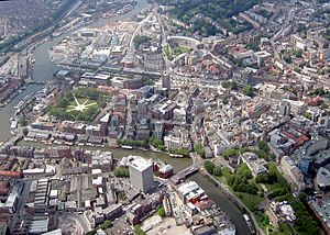
The Centre Promenade is a paved area in the city center. It's mostly for people walking. This area is built over a covered river called the River Frome. Many local buses start or end their journeys here.
Castle Park: History in the City
Castle Park is next to the Broadmead and Cabot Circus shopping centers. It's also close to the Floating Harbour. This park was created after bombs damaged the old shopping area during World War II.
You can still see the ruined walls of two old churches in the park: St Peter's and St Mary le Port. The foundations of Bristol Castle are also a cool feature. There are small gardens around St Peter's church, which is kept as a memorial.
Brandon Hill: Views and Nature
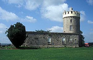
West of the city center, you'll find Berkeley Square and Brandon Hill. At the top of Brandon Hill stands the Cabot Tower. This tower remembers John Cabot, an explorer who sailed from Bristol in 1497.
Brandon Hill is quite steep. It has pretty gardens, a small nature reserve, and open grassy areas. The Avon Wildlife Trust has its main office right next to the park.
College Green: A Popular Meeting Spot
College Green is west of the city center. It's located between Bristol Cathedral and the Council House. This green space is a popular place for people to meet up and enjoy outdoor activities.
Queen Square: A Restored Georgian Gem
Queen Square is a large, beautiful square south of the city center. It was built in the Georgian style. In 1936, a road cut through the square. But now, the road has been moved, and the square has been restored to its original beauty. It has even won awards for its design.
Other Georgian squares north of the city center include King Square, Brunswick Square, and Portland Square.
The Bearpit: A Revitalized Space
Work began in 2014 to improve The Bearpit. This is a sunken area within the St James Barton roundabout. It now has new street-level crossings and wider stairs.
Other Parks Around Bristol
Bristol's suburbs also have many great parks and green spaces. Here are some of them:
- Arnos Vale Cemetery
- Begbrook Green Park
- Bristol & Bath Railway Path: A green path along an old railway line.
- Brunswick Cemetery Gardens: An old cemetery turned into a public park.
- Canford Park
- Cotham Gardens
- Crox Bottom: A park with Pidgeonhouse Stream running through it.
- Dame Emily Park
- Eastville Park
- Gores Marsh Park
- Greville Smyth Park
- Hengrove Park
- Lamplighters Marsh
- Leigh Woods: Owned by the National Trust.
- Manor Woods Valley Local Nature Reserve: The River Malago runs through it.
- Marksbury Road Open Space: Also has the River Malago.
- Mina Road Park
- Montpelier Park
- Northern Slopes: A group of open spaces including the Bommie and Novers Common.
- Oldbury Court Estate (also known as Vassalls Park)
- Page Park
- Perrett’s Park
- Redcatch Park
- Redland Green
- Ridgeway Playing Fields, Hillfields
- Riverside Park
- Royal Fort Gardens
- Snuff Mills: Owned by the National Trust.
- Sparke Evans Park
- St Agnes Park
- St Andrews Park
- St Anne's Park
- St George Park
- Stoke Park
- Victoria Park
Images for kids
 | John T. Biggers |
 | Thomas Blackshear |
 | Mark Bradford |
 | Beverly Buchanan |


