
The Centre, Bristol facts for kids

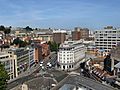
View of northern end of The Centre, March 2018, before removal of Colston statue
|
|

Location in Bristol Central
|
|
| Former name(s) | Tramways Centre |
|---|---|
| Maintained by | Bristol City Council |
| Location | Bristol, England |
| Postal code | BS1 |
| Coordinates | 51°27′14″N 2°35′50″W / 51.4540°N 2.5972°W |
| North | Lewins Mead, Rupert Street |
| East | Baldwin Street |
| South | Anchor Road |
| West | College Green |
The Centre is a busy open space in the middle of Bristol, England. It was created by building over the River Frome. The northern part is called Magpie Park. The southern part is a large paved area. It is surrounded by streets like St Augustine's Parade and Broad Quay. The Centre is looked after by Bristol City Council.
The name 'The Centre' became popular in the mid-1900s. Before that, from 1893, it was known as the Tramways Centre and Magpie Park. Even though it's called 'The Centre', it's not Bristol's oldest or main shopping area. However, it's a very important place for transport. Many local bus services stop here. You can also catch ferry services to Hotwells and Bristol Temple Meads station. There are also busy taxi ranks.
The Centre has changed many times over the years. At first, changes were made to help traffic flow better. More recently, changes have tried to balance its use as a public space and a busy road. In 2017, new changes were finished to make way for the MetroBus system.
Contents
How The Centre Was Made
Early Days of the Docks
The Centre exists because of a channel dug in the 1240s. This channel, called St Augustine's Reach, was made for ships. It helped Bristol's busy docks grow. Over time, ships became bigger. New docks were built further away. This made the old wharves at St Augustine's Reach less important.
The northern end of St Augustine's Reach was narrow. A bridge called The Drawbridge crossed it. This bridge often opened for ships. This caused big traffic jams, especially for the new trams. By 1893, the bridge was replaced with a fixed one.
Magpie Park's Beginning
In 1892, a new stone bridge, St Augustine's Bridge, was built. At the same time, the docks north of the bridge were filled in. This new area was named Magpie Park. It was surrounded by Colston Avenue. The park was named after a local newspaper, The Bristol Magpie. Its offices were nearby.
In 1893, a big exhibition was held here. It was called the Bristol Industrial and Fine Arts Exhibition. Over 500,000 people visited it. It also raised money for charity. Today, this is where the Bristol Cenotaph stands. The Cenotaph is a monument unveiled in 1932. It is still used for Remembrance Day events.
The Tramways Centre

In the 1890s, Bristol's tram system grew and became electric. In 1896, the Bristol Tramways and Carriage Company moved its main office nearby. A large triangular island was built for trams. It was nicknamed 'Skivvy's Island'. This Tramways Centre became the most important tram stop in the city. Trams from many parts of Bristol stopped here. Passengers could easily switch trams. A large clock was placed on the Tramways office building. Meeting "under the clock on The Centre" became a popular thing to do.
A writer named J. B. Priestley visited in 1933. He said The Centre was a place where "trams and coastal steamers seemed in danger of collision." Buses also started using The Centre in 1910. By 1939, buses had replaced all the trams here. All trams in Bristol stopped running by 1941.
Building the Inner Circuit Road
In 1938, work began to cover the area between St Augustine's Bridge and Broad Quay. This created a route for a new road called the Inner Circuit Road. A large roundabout was formed. At first, the middle of this space was used as a car park. After World War II, this central area was planted with lawns and gardens. It became known as the Centre Gardens.
Changes in the 1950s
The Inner Circuit Road was extended in 1957–58. The old Tramways Centre island was removed. The Centre Gardens were made bigger. Magpie Park became smaller. Colston Avenue was widened, and many old trees were cut down.
Remodelling in 1998
By the 1990s, people realised that the Inner Circuit Road had made areas like Queen Square and The Centre less pleasant. Plans were made to make The Centre better for people walking and using public transport.

In 1996, Bristol City Council asked the public for ideas. They could choose between two plans. One was to reopen the old harbour. The other, cheaper plan, was called the 'Promenade Option'. This option created a bigger walking area with fountains and a waterfall. It also had a sail-like structure. Both plans aimed to give more space to public transport.
The Council chose the 'Promenade Option'. However, the new design faced some challenges. There were concerns about safety for pedestrians. People also complained about traffic noise and slow traffic. The sail structure was later found to be unsafe and removed in 2009.
MetroBus Changes in 2015
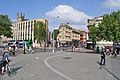
Between 2015 and 2018, The Centre was changed again. This time, it was to make space for the MetroBus system. Cars were moved to the western edge of The Centre. The old roundabout system was replaced with larger, easier-to-access walking areas. The new layout reduced the number of roads for general traffic. It also made it better for bikes and buses. Taxi ranks were moved, and new bus stops were built. These changes helped improve journey times.
Interesting Places to See
Magpie Park has the Bristol Cenotaph. It also has a bronze statue of Edmund Burke, a famous MP. There was also a statue of Edward Colston. On June 7, 2020, this statue was pulled down during a protest. A drinking fountain also remembers the 1893 exhibition.
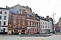
St Mary on the Quay church is on Colston Avenue, near the park. St Stephen's Church is also close by.
The southern part of The Centre has a lead statue of Neptune from 1723. It was moved here in 1949. There are modern water fountains. A stepped water feature leads down to a ferry landing. A busy taxi rank is on Colston Avenue.
The Bristol Hippodrome theatre is to the west of The Centre. Further north are the tall Beacon Tower and Bristol Beacon concert hall. On Broad Quay, a former office tower was turned into a hotel and flats in 2011.
The Centre is part of the College Green Conservation Area. This means it's a special area protected for its history and looks.
Images for kids
-
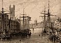
St Augustine's Reach, before 1850. This is where Magpie Park is now.
-
The Drawbridge, looking towards Clare Street and Baldwin Street.
-
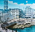
The Centre in 1958, showing the Inner Circuit Road and Centre Gardens.
-
A similar view of The Centre in 2005.
-
Magpie Park, before the changes in 2015.
-
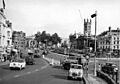
Looking across the newly extended Baldwin Street in 2018.
-
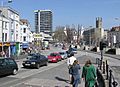
Magpie Park and St Stephen's Street in 2018.
-
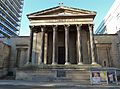
St Mary on the Quay Church.
,_BRO_Picbox-7-PBA-22,_1250x1250.jpg)
.jpg)


