St Jude's, Bristol facts for kids
Quick facts for kids St Jude's, Bristol |
|
|---|---|
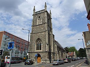
 The former St Jude's parish church. |
|
| Population | 2,755 |
| OS grid reference | ST600736 |
| Unitary authority | |
| Ceremonial county | |
| Region | |
| Country | England |
| Sovereign state | United Kingdom |
| Post town | BRISTOL |
| Postcode district | BS5 |
| Dialling code | 0117 |
| Police | Avon and Somerset |
| Fire | Avon |
| Ambulance | Great Western |
| EU Parliament | South West England |
| UK Parliament |
|
St Jude's is a busy area in the center of Bristol, England. It has homes, shops, and small factories. St Jude's is part of the Lawrence Hill area, which is managed by the Bristol City Council.
Contents
Exploring St Jude's Location
St Jude's is located in the eastern part of Bristol. It sits between other areas like Easton, Lawrence Hill, St Philip's Marsh, and St Paul's. This area has a mix of private and public homes. You will also find many shops and light industrial buildings here.
What Are St Jude's Boundaries?
The area of St Jude's has clear borders. To the north, it is next to the M32 motorway and the A4032 road. The Cabot Circus shopping center is to its west. To the east, it is bordered by the A4320 road.
Stapleton Road is a main street that runs through the middle of St Jude's. The eastern edge of St Jude's ends at Eugene Street and Trinity Road. Some parts of St Jude's were made part of the city center. This happened when Cabot Circus was built in 2006. In 2019, about 2,755 people in St Jude's were old enough to vote.
The History of St Jude's
St Jude's gets its name from an old church. This was the Church of England parish church of St Jude the Apostle. A person named Samuel Burleigh Gabriel designed the church. It was finished in 1849.
What Old Discoveries Were Made?
Workers once dug up a site where new homes were planned. This was near Little Anne Street and Wade Street. They found remains of houses from the 1700s. These homes belonged to people who worked with their hands, like craftspeople.
These old houses were removed before and after World War II. This was part of a plan to clear what was called 'slums'. Old records show that a building at 26 Wade Street was a factory. It made clay pipes. Many families who made pipes also lived in this area.
Things to Do in St Jude's
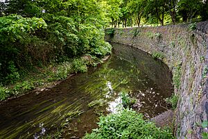
St Jude's has several parks for everyone to enjoy. The biggest one is Riverside Park. It is located along the River Frome. This park is also the start of the Frome Valley Walkway. Rawnsley Park is another park. It is on the eastern side of St Jude's, near Lawrence Hill.
Easton Leisure Centre is also in St Jude's. It has a swimming pool, a gym, and sports halls. These are open for the community to use.
Stapleton Road runs through the heart of St Jude's. Along this road, you can find many local shops. There is also a post office, pubs, take-away food places, and cafes.
Places of Worship in St Jude's
St Jude's has many buildings for different religions. Some are still used today, while others have been changed for new purposes.
Active Religious Buildings
Here are some of the places of worship that are still active:
- St Nicholas of Tolentino Roman Catholic Church
- St Mary's Orthodox Eritrean Church
- Great George Street Mission
- The Congregational Centre Chapel
- St Gabriel's Mission
- The Salvation Army's Logos House helps people who do not have homes.
Mosques
- Albaseera Bristol Centre
Former Religious Buildings
Some old religious buildings are still standing but are used differently now:
- The Trinity Centre is now a community hall.
- The St Jude the Apostle church is now private homes.
Getting Around St Jude's
St Jude's has good transport links. Many bus services run through the area. They are operated by First West of England. These buses connect St Jude's to the city center and other parts of Bristol.
Train Stations Near St Jude's
You can also reach St Jude's by train. The area is about 1.35 kilometers (0.84 miles) north of Bristol Temple Meads station. Two other train stations are very close to St Jude's. These are Lawrence Hill station and Stapleton Road station.
Road Connections
St Jude's is right next to the M32 motorway. This road connects it to the M4 and M5 motorways. The A4320 road also borders St Jude's. This road links the area to Bath.
 | Claudette Colvin |
 | Myrlie Evers-Williams |
 | Alberta Odell Jones |


