
River Biss facts for kids
Quick facts for kids River Biss |
|
|---|---|

The River Biss flowing under the town bridge in Trowbridge
|
|
| Country | United Kingdom |
| Region | Wiltshire |
| Physical characteristics | |
| Main source | near Upton Scudamore, Wiltshire 51°13′42″N 2°11′40″W / 51.22833°N 2.19444°W |
| River mouth | Staverton, Wiltshire 51°20′12″N 2°12′56″W / 51.33667°N 2.21556°W |
| Length | 18.385 km (11.424 mi) |
The River Biss is a small river located in Wiltshire, England. It flows into the Bristol Avon, which is a larger river. The name 'Biss' might come from an old language called Old Norse. In Old Norse, the word bisa means "to strive" or "to rush".
Contents
Journey of the River Biss
The River Biss begins its journey near Upton Scudamore. This area is on the western side of Salisbury Plain. At first, it's called the Biss Brook. It flows north, passing by the town of Westbury. As it gets closer to Trowbridge, near a place called Yarnbrook, the brook becomes the River Biss.
Historical Connections
The Baptist church in North Bradley is very close to the River Biss. In the 1800s, people used to hold special river baptisms here. More than 2,000 people would attend these events. The bridge in this area is still known as 'The Baptising' bridge.
The River in Trowbridge
The River Biss flows into the center of Trowbridge from the south-east. It passes through the Biss Meadows Country Park. This park is a special place, even though it's close to a town. It has many different types of wildlife. The park also helps to prevent floods. It acts as a natural flood plain, holding extra water when the river is high.
Through the Town Park
After Biss Meadows, the river goes around a pond. This pond was fixed up in 2012 by a group called "The Friends." The river then flows over a small waterfall, called a weir. It also goes around the car park of a large supermarket. In 1993, the river's path was changed here. Then, it flows under a big road called County Way.
The river then enters the Town Park. Here, there's a small lake where you can see wild birds. After the park, the river flows behind shops and other buildings. This area has a path called the Riverside Walk. This walk was opened in 1993 by the Duke of Edinburgh. The path is now mostly overgrown.
Before leaving the center of Trowbridge, the Biss flows under the Town Bridge. This bridge is near where the town got its name. In this part of the river, you can find a special plant. It's called the yellow water lily. People sometimes call it "Brandy Bottle." This is because of the shape of its fruit and its unique smell.
Water Supply History
Trowbridge used to be a town known for making woollen cloth. This industry needed a lot of water. However, the River Biss was never big enough to provide all the water needed. In 1874, a company tried to supply piped water to the town. But there wasn't enough water, and the company eventually failed. Their old building was on a street now called Waterworks Road.
Journey's End
After leaving the town center, the River Biss continues to flow north. It goes through an area called Ladydown. The river then passes under the Kennet and Avon Canal. This happens at a special bridge called the Biss Aqueduct. Finally, the River Biss flows into the River Avon. This meeting point is in Widbrook Wood, south of Staverton.
Images for kids
-
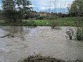
The River Biss during a flood, flowing over the weir.
-
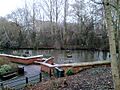
The lake in Trowbridge Town Park.


