
Salisbury Plain facts for kids

Salisbury Plain is a large, flat area made of chalk in southern England. It covers about 777 square kilometers (300 square miles). Most of it is in Wiltshire, with a small part in Hampshire.
This area is well-known for its amazing archaeology, which is the study of old human history. Famous sites like Avebury and Stonehenge are here. They are even recognized as a World Heritage Site. Salisbury Plain doesn't have many people living on it. It's the biggest area of special chalky grassland left in north-west Europe. You can also find farmland, some beech trees, and conifer forests here.
The British Army uses a large part of Salisbury Plain. It's their biggest training ground in England. The flat land is perfect for tank exercises. Old buildings, like those in the village of Imber, are used to practice urban warfare.
Contents
A Look Back in Time: History of Salisbury Plain

Salisbury Plain has a long and interesting history. People have lived here for thousands of years.
Stone Age Settlements
During the Neolithic period, which was the New Stone Age, people started to settle on the plain. They likely gathered around a large, fenced area called Robin Hood's Ball. They built huge long barrows, which are ancient burial mounds, like White Barrow. Other earthworks, which are shapes made in the ground, were also created.
By 2500 BC, areas near Durrington Walls and Stonehenge became very important. People built many structures there. The southern part of the plain continued to be settled into the Bronze Age.
Iron Age Hill Forts
Around 600 BC, during the British Iron Age, people built strong Hill forts. These were large forts on top of hills. They were built around the edges of the plain. Some examples include Scratchbury Camp and Battlesbury Camp in the southwest. There was also Bratton Camp in the northwest and Casterley Camp to the north. Other forts like Yarnbury and Vespasian's Camp were to the south. Sidbury Hill was in the east.
Roman and Anglo-Saxon Times
You can still see parts of old Roman roads on the plain. These roads probably led to a settlement near Old Sarum. However, there weren't many large Roman Villas here. This suggests the area was mostly used for growing grain.
In the 6th century, Anglo-Saxons arrived. They built new villages in the valleys. The hills were left as pasture for sheep. The city of Salisbury is to the south of the plain. Its cathedral, built in the 13th and 14th centuries, is famous. It has the tallest spire in the country. For many years, it was the tallest building in Britain. The cathedral shows how rich the area became from the wool and cloth trade.
Changes in the 19th Century
In the mid-19th century, the wool and cloth industry started to decline. This meant fewer people lived on the plain. The land use changed from sheep farming to growing crops and for military use. During this time, Wiltshire became one of the poorest counties in England.
Unique Features and Inventions
There are several chalk carvings on the plain. The most famous one is the Westbury White Horse. The Kennet and Avon Canal was built just north of the plain. It runs through the Vale of Pewsey.
In 1896, two inventors, George Kemp and Guglielmo Marconi, experimented with wireless telegraphy on Salisbury Plain. They sent messages without wires over a distance of about 2 kilometers (1.25 miles). This was a big step for communication!
Where Does Salisbury Plain End?
The exact edges of Salisbury Plain are not strictly defined. People have different ideas about how big it is. The river valleys around it, and other nearby hills and plains, generally mark its boundaries.
To the north, the steep edge of the downs looks over the Vale of Pewsey. To the northwest, you'll find the River Avon. The River Wylye flows along the southwest side. The River Bourne runs to the east.
Images for kids
-
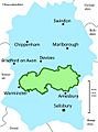
Rough map of military training area (green) on Salisbury Plain within Wiltshire (blue) (it accounts for about half the area of Salisbury Plain)
-
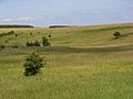
Typical grassland at Netheravon Down.
-

The burnt-tip orchid (Neotinea ustulata) can be found on Salisbury Plain
-
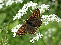
The Duke of Burgundy butterfly (Hamearis lucina)
-
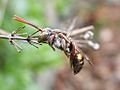
The cuckoo bee Nomada armata
-
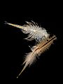
The fairy shrimp Chirocephalus diaphanus
-
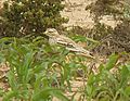
The stone curlew


