
Imber facts for kids
Quick facts for kids Imber |
|
|---|---|
 Part of the Urban warfare training area at Imber; original dwellings in centre |
|

Imber
|
|
| Population | 0 |
| OS grid reference | ST965485 |
| Civil parish | |
| Unitary authority |
|
| Ceremonial county | |
| Region | |
| Country | England |
| Sovereign state | United Kingdom |
| Postcode district | SN10 |
| Police | Wiltshire |
| Fire | Wiltshire |
| Ambulance | Great Western |
| EU Parliament | South West England |
| UK Parliament |
|
Imber is a village in Wiltshire, England, that no one lives in anymore. It's located on Salisbury Plain, which is a large area used by the British Army for training. Imber is quite isolated, about 2.5 miles (4 km) west of the A360 road.
In 1943, during the Second World War, all the people living in Imber were asked to leave. This was so American soldiers could use the village to practice for the invasion of Europe. After the war ended, the villagers were not allowed to return to their homes.
Today, Imber is still controlled by the Ministry of Defence, which is the government department in charge of the country's armed forces. Even though some former residents have tried to move back, they haven't been able to. The village is usually closed to the public. However, it opens a few times a year for visitors.
People have lived in the area around Imber since the Iron Age, long before the Romans came to Britain. The village was first mentioned in history in 967, during Saxon times. It was also listed in the Domesday Book, a famous survey from 1086. Back then, about 50 people lived there.
The village has a church that was built in the 13th century. By the 14th century, around 250 people called Imber home. The population reached its highest point in 1851, with about 440 residents. When everyone had to leave in 1943, about 150 people were affected.
Contents
Why Imber Became a Training Area
The War Office, which was the government department in charge of the army, started buying land on Salisbury Plain in the late 1800s. They used this land for military exercises. In the late 1920s, they began buying farms and land around Imber itself.
Land Purchases and Agreements
At the time, farming was difficult due to an economic depression. The military offered good prices for the land. This encouraged many landowners to sell. The new agreements allowed the War Office to take control and, if needed, ask people to leave. By the time the Second World War began, almost all the land in and around Imber belonged to the War Office. Only the church, vicarage, chapel, schoolroom, and the local pub (called the Bell Inn) were not owned by them.
The Eviction of Villagers
On November 1, 1943, a very important meeting was held in the village schoolroom. The Allied forces were getting ready for a huge invasion of mainland Europe. The people of Imber were told they had 47 days to leave their homes.
Reasons for Leaving
The village was needed by US forces to practice street fighting. Also, it was very close to areas where shells might land during training. Most villagers were sad to leave, but they understood it was their duty to help with the war effort. They even left canned food in their kitchens, believing they were making a sacrifice for the greater good.
Life After the Eviction
The villagers received limited money to help them move. One family on a farm had to be forced to leave by the Army. After the war, the villagers hoped to return, but they were never allowed back to their homes in Imber.
Images for kids
-
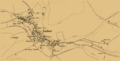
Ordnance Survey map of Imber from 1902
-
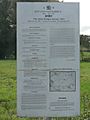
The Imber Ranges by-laws
-
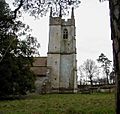
The tower of St Giles' in 2002
-
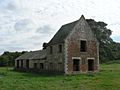
The former Seagrams Farm
-
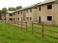
Houses used for training purposes
-
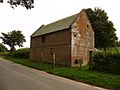
This building was a pub known as The Bell
-
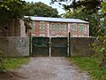
Imber Court building


