Heytesbury facts for kids
Quick facts for kids Heytesbury |
|
|---|---|
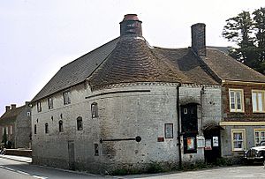 A late 18th-century former maltings, Heytesbury |
|
| Population | 696 (in 2011) |
| OS grid reference | ST925426 |
| Civil parish |
|
| Unitary authority |
|
| Ceremonial county | |
| Region | |
| Country | England |
| Sovereign state | United Kingdom |
| Post town | Warminster |
| Postcode district | BA12 |
| Dialling code | 01985 |
| Police | Wiltshire |
| Fire | Wiltshire |
| Ambulance | Great Western |
| EU Parliament | South West England |
| UK Parliament |
|
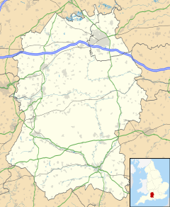
Heytesbury is a village in Wiltshire, England. It used to be considered a town. The village is located on the north bank of the River Wylye. It is about 5.6 kilometers (3.5 miles) southeast of Warminster.
The wider area of Heytesbury includes the small village of Tytherington. It also includes the deserted village of Imber.
Contents
Exploring Heytesbury's Past
Ancient Times and Early Settlements
The chalk hills north of Heytesbury village have very old earthworks. These include long and round burial mounds called long barrows and round barrows. You can also see old farm terraces, known as strip lynchets, near Cotley Hill.
The parish is located between two Iron Age hillforts. These are Scratchbury Camp and Knook Castle. On Tytherington Hill, people have found signs of a Romano-British settlement. Chapperton Down, west of Imber, also shows evidence of ancient homes and farm fields.
Heytesbury in the Domesday Book
In 1086, the Domesday Book recorded a small settlement here called Hestrebe. It had eight households and a church. The larger area, known as the hundred of Heytesbury, included seventeen different places.
The Hungerford Family and Heytesbury's Growth
The Hungerford family owned land in Heytesbury by the late 1300s. They raised many sheep in the area during the 1400s. Important family members include Walter Hungerford, 1st Baron Hungerford of Heytesbury.
In the 1800s, Heytesbury was described as a small town. It was located on the River Wylye and had a railway station. The town was almost completely destroyed by fire in 1766 but was rebuilt. It became known as a place for tourists interested in ancient sites.
Heytesbury's Parliament History
From 1449 to 1832, Heytesbury was a parliamentary borough. This meant it could send two Members of Parliament to the UK Parliament. However, it was a special type of borough called a burgage borough. Only householders of certain properties could vote.
By 1832, there were only 26 such properties. The A'Court family owned all of them, giving them full control over who became an MP. The Reform Act 1832 changed this system. It stopped these "rotten boroughs" and gave more people the right to vote.
Education in Heytesbury
An elementary school opened in Heytesbury in 1838. It was located near the church. By 1858, about 50-60 older students and 40-50 younger children attended.
The school moved to a new location in 1900. It became part of Wiltshire County Council's system. Until 1931, children of all ages went there. After that, students over 11 moved to a new school in Warminster. Today, the school is called Heytesbury CofE Primary School. It serves children from Heytesbury and Tytherington.
Places of Worship
Church of England Churches
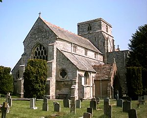
A church was first mentioned in Heytesbury in 1086. It became a collegiate church in the 1100s. The current parish church dates from the 1200s. It is a Grade I listed building, meaning it is very important historically.
In Tytherington, a chapel was built in the 1100s. The small church of St James is mostly from the 1500s. It is a Grade II* listed building.
St Giles' Church, Imber, was built in the late 1200s. It is also a Grade I listed building. This church is no longer used for regular services. It is now looked after by the Churches Conservation Trust.
Other Churches
A Congregational chapel was built in Heytesbury village in 1812. It was replaced around 1868. This chapel closed sometime after 1955. There was also a Primitive Methodist chapel in Tytherington.
Famous People Connected to Heytesbury
- Elizabeth Wydeville (1437–1492) lived at East Manor in Heytesbury. She was the wife of King Edward IV. After the King's death, she stayed here with her daughters, including Elizabeth of York.
- The historian William Cunnington (1754–1810) was from Heytesbury. He studied many ancient sites on the nearby hills.
- Heytesbury House was built for the Ashe à Court family. Sir William à Court became a Baronet in 1795. His son, also Sir William, became the first Baron Heytesbury in 1828.
- The famous poet Siegfried Sassoon lived the last part of his life at Heytesbury House. He bought it in 1933. His son George Sassoon grew up there. George inherited the house in 1967 and lived there until 1996.
- Major-General Glyn Gilbert (1920–2003) also made Heytesbury his home.
Important Buildings in Heytesbury
Heytesbury House
Heytesbury House is a large country house. It was rebuilt in 1782 and is a Grade II* listed building. In 1985, part of the park around the house was taken for the A36 bypass road. This separated the house from its cricket field.
The old gate pillars at the former southern entrance are still there. In the early 2000s, the house and its stables were turned into several homes.
Hospital of St John and St Katherine
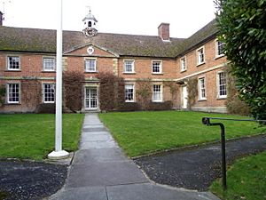
The Hospital of St John and St Katherine was founded in 1442. It was started by Walter Hungerford, 1st Baron Hungerford. It was later supported by his son's widow, Margaret. This almshouse provided homes for twelve poor unmarried men and one woman. A chaplain oversaw the hospital.
Around 1769, the original hospital burned down. A new building was built, forming three sides of a square. The architect was Esau Reynolds. In 1968, the building became a Grade II listed building. It still operates today as a registered charity.
Heytesbury Lock-up
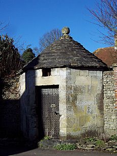
On the High Street, you can find a small, octagonal building. This is a village lock-up, also called a blind house. It was likely built in the 1700s. These buildings were used to temporarily hold people who had committed minor offenses.
Getting Around Heytesbury
The A36 road now goes around the north of the village. An old map from 1958 shows that the road used to go right through the High Street. The Wessex Main Line railway runs south of the village. It opened in 1856. Until 1955, there was a train station on the road between Heytesbury and Tytherington.
 | Emma Amos |
 | Edward Mitchell Bannister |
 | Larry D. Alexander |
 | Ernie Barnes |


