Warminster facts for kids
Quick facts for kids Warminster |
|
|---|---|
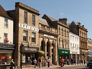 Market Place, Warminster |
|
| Population | 18,173 (2021 Census) |
| OS grid reference | ST875455 |
| Unitary authority |
|
| Ceremonial county | |
| Region | |
| Country | England |
| Sovereign state | United Kingdom |
| Post town | Warminster |
| Postcode district | BA12 |
| Dialling code | 01985 |
| Police | Wiltshire |
| Fire | Wiltshire |
| Ambulance | Great Western |
| EU Parliament | South West England |
| UK Parliament |
|
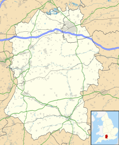
Warminster is a historic market town in south-west Wiltshire, England. It sits on the western edge of Salisbury Plain. In 2021, about 18,173 people lived in the town.
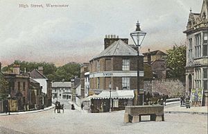
The name Warminster first appeared in the early 900s. The Minster Church of St Denys was started in the 1000s. The High Street and Market Place have many beautiful buildings. These include the Athenaeum Centre, the Town Hall, and St Lawrence Chapel. You can also find many local shops there. Several Army bases, known as the Warminster Garrison, are located near the town.
Contents
- What's in a Name?
- Warminster's Past
- Places of Worship
- Important Buildings and Structures
- How Warminster is Governed
- Warminster's Location
- How Many People Live Here?
- Warminster's Economy
- Fun Things to Do in Warminster
- Local News and Media
- Military Presence
- Getting Around Warminster
- Sports in Warminster
- Schools in Warminster
- Public Services
- Famous People from Warminster
- Twin Towns
- UFO Sightings
- See also
What's in a Name?
The name Warminster comes from old words. Wor comes from wara, an Old English word. It means "those who watch or protect." This word was used by early groups like the Goths and Jutes. It might have been linked to the ancient fort at Battlesbury Camp.
The town's name has changed over time. In the early 900s, it was called Worgemynstre. In the Domesday Book, it was Guerminstre. The word minster comes from mynster, an Old English word for a monastery or main church. Saxon settlers gave this name to the town in the 600s.
Warminster's Past
Early Beginnings
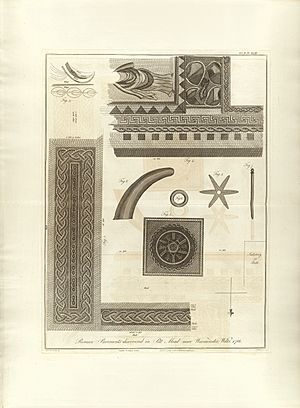
The main settlement in Warminster began in the Anglo-Saxon period. However, people lived here even earlier. There is proof of prehistoric settlements at nearby Iron Age hill forts. These include Battlesbury Camp, Scratchbury Camp, and Cley Hill. Two Roman villas and Roman coins have also been found in the area.
By the 900s, Warminster had a royal estate and an Anglo-Saxon church. Most residents worked for the estate. In the 1100s, new lords took over the royal estate, and the town started to grow. A market was set up in the 1200s. By 1377, Warminster had 304 people who paid a special tax. This made it the tenth largest town in Wiltshire.
Civil War Times
During the English Civil War (1642-1645), Warminster saw some action. A leader for the "Roundheads" (Parliament's army), Henry Wansey, was surrounded in Warminster. Another force tried to help him and had a small fight on Warminster Common. By 1646, the town had suffered about £500 in damage because it supported the Roundheads.
Growing Wealth After Medieval Times
Warminster's market was key to its success. By the 1500s, the town was important for wool, clothing, and malting (making malt for brewing). These trades were the town's main economy until the 1800s. The market also had a big corn trade. In 1830, it was the second largest corn market in western England. Farmers had to bring a sack of corn from each load for customers to see. Deals were made between 11 am and 1 pm and paid for by the end of the day.
The town had many places for market visitors to stay. In 1686, it was ranked fourth in Wiltshire for places to stay, with 116 beds. By 1710, there were about fifty inns and alehouses. Warminster was also quick to improve its roads. It used the Turnpikes Act to fix seven roads around the town. These roads were all less than 3 miles long.
By the late 1700s, about 200 homes were built by people settling on land without permission. Many of these homes were poor and crowded. A minister in the 1800s heard stories from a woman born there in the 1770s. She described homes with dirt floors and piles of rubbish that made the local stream dirty. This caused diseases like typhus and smallpox. People living there were seen as rude and criminal. However, by 1833, the area had become clean and respected, thanks to efforts from ministers and others.
The 1800s and 1900s
The town centre was changed after 1807. George Wansey, a wealthy cloth maker, left £1,000 to improve the town. This money was used to knock down houses and make roads wider. In 1851, a railway line from Westbury opened. In 1856, the line was extended to Salisbury. The railway greatly harmed the town's market. It almost disappeared, and shops and inns lost most of their business. Local industries also declined.
In 1907, a group was formed to promote the town. They created a town guide and advertised nationally. The luxury glove makers Dents moved their main office and factory to Warminster in 1937. They have been there ever since.
Between 1937 and 1965, the military presence in Warminster grew a lot. New camps, a permanent barracks at Battlesbury, and training schools were added.
Places of Worship
Church of England
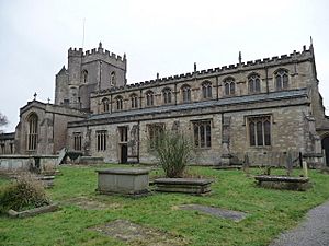
St Denys's Church is the oldest church in Warminster. It is believed to have been a "minster" church, meaning it was a very important church, as early as the 900s. The church was rebuilt in the 1300s and again mostly in 1889.
As Warminster's population grew in the 1800s, two more churches were built. Christ Church was built in 1831 for the south of town. St John's was built in 1865 in the southeast. All three churches are listed for their historical importance.
Town Chapel
The chapel of St Lawrence is on the High Street, near the market. It has been a "chapel-of-ease" (a smaller church for local people) to St Denys since at least 1290. Its tower is from the late 1200s or early 1300s. The rest was rebuilt in 1855–1857. The townspeople bought the chapel in 1574. This made it a "non-royal peculiar," meaning it was outside the usual control of the Church of England. Since then, it has been managed by trustees for the town.
Other Churches
Methodists built a chapel on George Street in 1804. It was rebuilt in 1861. This church joined with the United Reformed Church in 1983 to form the United Church.
The Baptist chapel in North Row was built in 1810. By 1829, it had 250 members.
St Giles' Garrison Church, for military personnel, was built in 1968. St George's Roman Catholic Church was built in 1922.
College and Convent
James Erasmus Philipps, a vicar of St Denys, started a college for young men in 1860. This became St Boniface Missionary College. Its building was made much larger in 1901 and 1927. From 1948 to 1969, it was a special college for university graduates. Today, its buildings are part of Warminster School.
Philipps also helped start an order of nuns, the Community of St. Denys, in 1879. The nuns ran St Monica's School for Girls. This school later joined with Lord Weymouth's Grammar School in 1973 to create Warminster School.
Important Buildings and Structures
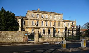
Warminster has one Grade I listed building: Portway House. It is north of the town centre and was built in 1722 for a rich cloth maker. This house is made of Bath stone and has a grand front with seven sections.
Other important Bath stone houses include 38–40 Market Place, which are now shops. The Chantry, at 34 High Street, is also notable. Both are Grade II* listed.
Other Grade II* listed buildings include the churches of St Denys and St John. Byne House, built in 1755, and Warminster School, built in 1708, are also listed. Wren House, built around 1720 or 1730, is a beautiful example of an early Georgian house. The Pound Street maltings, used for making malt, were rebuilt in 1879. The Athenaeum Centre, built in 1857, is Wiltshire's oldest working theatre. It has been showing films since 1897.
At a street junction stands a tall stone obelisk. It has a fancy top and was put up in 1873. It marks the time when the parish land was divided up.
Warminster Town Hall was designed around 1837. Its front looks like a smaller version of Longleat, a famous country house. It has a bell, a clock, and a coat of arms. The building was sold in 1979.
How Warminster is Governed
Warminster is part of the parliamentary constituency of South West Wiltshire. This area has been represented by Andrew Murrison from the Conservatives since 2001.
There are two main levels of local government. Wiltshire Council is the main authority for the county. Warminster Town Council has 13 elected councillors who look after local matters.
Warminster's Location
 |
Bath | Westbury | Market Lavington |  |
| Shepton Mallet | Shrewton | |||
| Wincanton | Shaftesbury | Salisbury |
Warminster is in south-west Wiltshire, close to the border with Somerset. Six hills surround the town, which helped protect early settlers. Warminster is also near the old Selwood Forest.
A small river called The Were flows through the town. It joins the River Wylye on the south-east side.
| Climate data for Bath (Nearest climate station to Warminster) | |||||||||||||
|---|---|---|---|---|---|---|---|---|---|---|---|---|---|
| Month | Jan | Feb | Mar | Apr | May | Jun | Jul | Aug | Sep | Oct | Nov | Dec | Year |
| Mean daily maximum °C (°F) | 7.6 (45.7) |
7.9 (46.2) |
10.5 (50.9) |
13.5 (56.3) |
16.7 (62.1) |
19.7 (67.5) |
22.7 (72.9) |
21.5 (70.7) |
18.8 (65.8) |
14.6 (58.3) |
10.7 (51.3) |
8.0 (46.4) |
14.3 (57.7) |
| Mean daily minimum °C (°F) | 1.9 (35.4) |
1.7 (35.1) |
3.5 (38.3) |
4.6 (40.3) |
7.5 (45.5) |
10.4 (50.7) |
12.5 (54.5) |
12.4 (54.3) |
10.3 (50.5) |
7.6 (45.7) |
4.5 (40.1) |
2.3 (36.1) |
6.6 (43.9) |
| Average rainfall mm (inches) | 82.5 (3.25) |
53.2 (2.09) |
63.7 (2.51) |
56.9 (2.24) |
59.7 (2.35) |
51.9 (2.04) |
55.8 (2.20) |
65.7 (2.59) |
66.6 (2.62) |
88.5 (3.48) |
82.7 (3.26) |
87.2 (3.43) |
824.1 (32.44) |
| Source: Met Office | |||||||||||||
The small villages of Bugley and Boreham are now part of Warminster's suburbs.
How Many People Live Here?
The Domesday Book survey in 1086 counted 104 households in Warminster. Most were craftspeople working for the royal estate. By 1377, the population had grown to 304 tax payers. This made Warminster the tenth largest village in Wiltshire. In 1665, there were 354 households, about 1,800 people. By 1781, the area within the main roads had 2,605 people.
| Historical population of Warminster | |||||||||||
| Year | 1801 | 1811 | 1821 | 1831 | 1841 | 1851 | 1861 | 1871 | 1881 | 1891 | 1901 |
|---|---|---|---|---|---|---|---|---|---|---|---|
| Population | 4,932 | 4,866 | 5,612 | 6,115 | 6,211 | 6,285 | 5,995 | 5,786 | 5,640 | 5,563 | 5,547 |
| Year | 1911 | 1921 | 1931 | 1941 | 1951 | 1961 | 1971 | 1981 | 1991 | 2001 | 2011 |
| Population | 5,492 | 5,387 | 5,176 | – | 7,660 | 9,860 | 13,554 | 15,089 | 16,267 | 17,377 | 17,490 |
|
Census: 1801–2011 |
|||||||||||
Warminster's Economy
Warminster is in a fertile area, so its early economy was mostly farming, especially cereals. The town's market was the backbone of its economy from the 1500s to the 1800s. Besides cereals, wool and clothing were traded. There were also many places that made malt for brewing.
Warminster's clothing trade suffered in the early 1800s. There was no suitable river to power new factory machines. At the same time, its malting trade declined but remained important. In 1855, the Pound Street Maltings were built. Today, malt is again produced there.
When the railway line opened in 1851 (and extended to Salisbury in 1856), it badly affected the town's market. The market almost disappeared, and shops and inns lost most of their business. In 1860, Warminster was described as a "poor place." However, by that year, the town started new trades like brewing and iron-founding. These new businesses grew enough to make up for the losses. For example, the Woodcock Ironworks started in the 1870s to make farm machines.
In the 1900s, Warminster's economy became more reliant on the British Army and related services. Other new businesses also came, such as poultry farming, banana ripening, and shoe making. In the late 1900s and early 2000s, the leisure industry grew. Longleat and Center Parcs Longleat Forest became major employers.
Fun Things to Do in Warminster
Warminster has a library, a museum, a theatre, and a sports centre with a pool. It also has many local shops and restaurants. The community is active, with groups like 'The Athenaeum Singers' choir. Yearly events include an illuminated carnival and heritage open days.
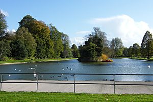
The Athenaeum is a historic building from 1858. It is Wiltshire's oldest working theatre. It was originally a place for lectures, plays, and concerts. Now, it is a theatre and community centre. The Lakeside Pleasure Grounds have play areas, tennis courts, a skate park, and a splash pool. There is also a boating lake that leads to the Henford's Marsh nature reserve. The park opened in 1924.
About 4 miles west of Warminster is Longleat. This is the country home of the Marquess of Bath. Its estate includes Longleat Safari Park, which opened in 1966. It was the first drive-through safari park outside Africa. It is home to over 500 animals, including lions, tigers, and giraffes. The nearby Longleat Forest also has a Center Parcs holiday village.
Local News and Media
The Warminster Journal is the local newspaper. It has been published weekly since 1881 and covers the town and nearby villages. The town is also covered by the Wiltshire Times, another weekly newspaper.
Local TV news is provided by BBC West and ITV West Country.
BBC Radio Wiltshire is the local public radio station. Warminster Community Radio (WCR) broadcasts from the Civic Centre on 105.5 FM and online. There is also a commercial radio station on 107.5 FM. Since 2019, this station has been owned by Bauer Radio. In September 2020, it was rebranded as Greatest Hits Radio Bath & The South West.
Military Presence
The British Army's Waterloo Lines is home to several Army training schools. It also houses a large part of the Headquarters Field Army. This site is also home to the Headquarters Small Arms School Corps and Headquarters Infantry. These groups are in charge of recruiting and training for the Infantry. Harman Lines is a smaller base nearby.
Battlesbury Barracks is home to the Royal Dragoon Guards, an armoured cavalry regiment. From 2005 to 2020, parts of the Yorkshire Regiment were based here. The regiment's 3rd Battalion was given the freedom of the town in 2012.
Getting Around Warminster
Warminster is at the meeting point of two main roads, the A36 and the A350. Both roads now go around the town to the south and east. There is a service area where the two roads meet. The A303 is about 7 miles south of the town. Motorway junctions 17 and 18 of the M4 are about 22 miles to the north.
Warminster railway station opened in 1851. It is a stop on the Wessex Main Line. Two train companies serve it:
- Great Western Railway runs regular trains to Bristol, Cardiff, Southampton, and Portsmouth. You can reach London by changing trains at Westbury.
- South Western Railway runs trains between London Waterloo and Yeovil, via Salisbury.
Warminster's bus services are run by First Bristol, Beeline Coaches, and FromeBus. Routes connect the town with Bath, Frome, and Salisbury. Berrys Coaches runs a "Superfast 3" route between Taunton and London.
Sports in Warminster
Warminster has a long history of sports. Many clubs were started in the 1800s. Warminster Cricket Club began in 1838. Its facilities are shared with the local hockey and table tennis clubs. The West Wilts Hockey Club started around 1899. As of 2016, it had 13 adult teams. The town's Elm Hill golf course was designed in 1891.
Warminster Town Football Club started around 1878. Their ground was updated in the 1990s. They play in Division One of the Western League. The town has a competitive swimming club. Warminster Rugby Club began in 1977.
More recent additions include the Warminster Sports Centre, Warminster Running Club, and Wessex Blades Fencing Club.
Schools in Warminster
Warminster has several primary schools. It also has two secondary schools: Warminster School, an independent school founded in 1707, and Kingdown School, which became an academy in 2011. Nearby Bishopstrow College helps international students prepare for boarding school.
Public Services
Utilities
Wessex Water provides the town's water and sewage services. The water in the town centre is considered hard. The companies that supply electricity and gas are part of SSE plc.
Healthcare
The town has one doctor's practice, the Avenue Surgery. The small Warminster Community Hospital has an inpatient ward. The nearest minor injuries unit is in Frome. The closest general hospitals with emergency departments are Salisbury District Hospital and the Royal United Hospital in Bath. Ambulances are provided by the South Western Ambulance Service.
Policing
The town is covered by Wiltshire Police. They have a station at The Avenue, near the fire station. The Ministry of Defence Police and Royal Military Police are also sometimes seen in town. This is because the Warminster Garrison and Salisbury Plain training area are policed by all three groups.
Fire Service
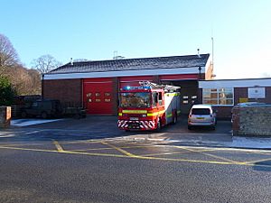
Warminster has a fire station. Its retained firefighters are provided by Dorset & Wiltshire Fire and Rescue Service. They respond to emergencies when called.
Famous People from Warminster
- William Aldridge (1737–1797), a minister
- Freddie Bartholomew (1924–1992), a child actor
- Rupert E. Billingham (1921–2002), a biologist
- Benjamin Buckler (1716–1780), a historian
- Beryl May Dent (1900–1977), a physicist
- Henry Huntingford (1787–1867), a scholar and clergyman
- John Philipps, 1st Viscount St Davids (1860–1938), a politician
- Henry Wansey (1751–1827), a wool manufacturer and traveller
Twin Towns
Warminster is twinned with:
- Flers, France
- Warminster, Pennsylvania, United States
UFO Sightings
Warminster was known for several UFO sightings in the 1960s and 1970s. The first sighting was on December 25, 1964. Arthur Shuttlewood recorded many more sightings over the next year. He gave his notes to the Daily Mirror newspaper, which published the story. This made the town famous for UFO sightings. It led to a BBC documentary in 1966 and several books. There was also a conference about UFOs in 2009 and another in 2010 with UFO expert Nick Pope.
See also
 In Spanish: Warminster para niños Other places named Warminster:
- Warminster, Virginia, United States, a small community
- Warminster Township, Pennsylvania, United States
- Warminster, a community in Oro-Medonte, Ontario, Canada
 | Precious Adams |
 | Lauren Anderson |
 | Janet Collins |


