Scratchbury Camp facts for kids
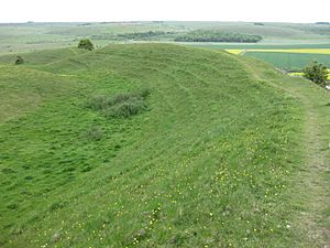
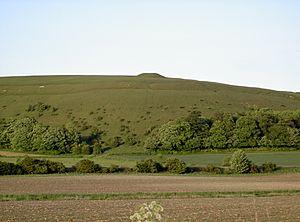
Scratchbury Camp, viewed from Battlesbury Hill
|
|
| Location | Wiltshire |
|---|---|
| Region | Southern England |
| Coordinates | 51°11′50″N 2°07′39″W / 51.1973°N 2.1274°W |
| Type | Univallate hillfort |
| Area | 37 acres (15 ha) |
| History | |
| Material | Chalk |
| Periods | Bronze Age, Iron Age |
| Associated with | Belgae |
| Site notes | |
| Excavation dates | 1810, 1930, 1957, 1991 |
| Archaeologists | E.C.Curwen W.F.Grimes William Cunnington Sir Richard Colt Hoare |
| Condition | good |
| Public access | footpaths |
| Official name | Scratchbury Hill Monuments |
| Identifiers | |
| NHLE | 1010213 |
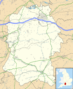
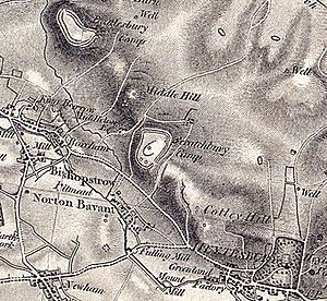
Scratchbury Camp is an ancient hillfort located on Scratchbury Hill in Wiltshire, England. It overlooks the Wylye valley and is about 1 kilometer northeast of Norton Bavant village. This large fort covers about 37 acres (15 hectares). It sits on top of the hill, and its four-sided shape mostly follows the natural curves of the land.
The main hillfort was built during the Iron Age, around 100 BC. However, it also contains traces of an older, smaller D-shaped enclosure or camp. Experts are still debating how old this earlier earthwork is. Some think it's from the early Iron Age (around 250 BC), while others believe it's much older, from the Bronze Age (around 2000 BC).
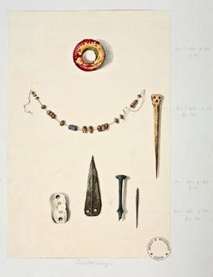
Inside the fort, there are seven ancient burial mounds called tumuli. These were explored in the 1800s by Sir Richard Colt Hoare and William Cunnington. They found interesting items like bone, pottery, flint, brass, and amber jewelry. Many of these finds are now on display at the Wiltshire Museum in Devizes. Other discoveries around the site include Roman artifacts and Neolithic flint and jade axe heads.
Scratchbury Camp is a protected historical site. It is also part of a special natural area called Scratchbury & Cotley Hills SSSI. This area is important for its wildlife and plants.
Contents
What's in a Name?
The name "Scratchbury" might come from old English words. One idea is that "scratch" was an old word for the Devil in the West Country. "Bury" comes from "beorg," meaning a mound or hill, or sometimes a defense.
Another idea is that "Crech" or "Crechen" meant a hill. And "burh" meant a fortified town or a defended place. So, the name could mean "Devil's Hill" or "Fortified Hill."
Exploring the Hillfort
The Iron Age Hillfort Design
Scratchbury Hill has very steep sides on its north, west, and southwest. These steep slopes acted as natural defenses. Some parts of the eastern side also have steep slopes. Other areas of the hill are less steep, making them easier to access.
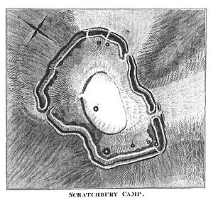
The Iron Age defenses at Scratchbury Camp include a single large ditch and a rampart. These are found on the steepest sides of the hill. Some areas also have extra smaller banks called counterscarps where access was easier. The fort's outer walls measure about 1,846 yards (1,688 meters) around.
The inner earthworks were made using a "quarry-ditch" method. This means the material dug from the inner ditch was used to build the rampart. Inside this ditch, there are many circular hollows. These might be the remains of ancient buildings.
The defenses are best preserved on the western side. Here, the ditch is 5 to 8 meters (16 to 26 feet) wide and up to 1 meter (3 feet) deep. The banks and ditches are not all the same height or depth. This suggests that different groups of workers might have built different parts of the earthworks.
There are two original entrances on the eastern side of the fort. There might also be a third entrance on the northwest side. The southeastern entrance has signs of outer defenses. It is approached by a narrow ridge of land called Burberry.
Much of the northern and western parts of the fort's inside seem to have been busy. There are traces of about 100 possible structures. These look like shallow circular hollows, 5 to 10 meters (16 to 33 feet) across and up to 0.6 meters (2 feet) deep. One rectangular platform is especially well-preserved. It is just inside the western entrance. Its location suggests it might have been a "guard chamber" or a place for a sentry.
The Older Enclosure
In the middle of the hillfort, you can find what's left of an older, smaller D-shaped enclosure. This area is about 3.5 hectares (8.6 acres). Today, the most visible part is a well-defined bank, about 0.5 meters (1.6 feet) high, along the southern section.
When E.C. Curwen excavated in 1930, he thought this was a Neolithic "causewayed enclosure." This is because it had gaps, and he found jade and flint axes there. Later, in 1957, W.F. Grimes re-examined it. He thought it was an earlier Iron Age enclosure from around 250 BC. He found Iron Age pottery. He believed the gaps were caused by later farming.
However, more recent aerial photos and surveys from the 1990s suggest Curwen might have been right. The feature looks more like a Neolithic causewayed enclosure. Low winter sun photos show it continues beyond what was thought to be its eastern edge. This suggests it was more circular than D-shaped. This older enclosure might also be linked to the barrow cemetery around it.
Later Changes
There is also a ditch from the Roman-British period or later. It runs east to west and then sharply south. This ditch partly covers the older Iron Age earthworks. The main ramparts of the hillfort seem to have been built in the 1st century BC.
How the Fort Was Built
Archaeologists believe Scratchbury Camp was built in at least two, maybe even three, stages. The first stage involved the curved part of the inner D-shaped enclosure. It's not clear if there were two distinct Iron Age stages or just one big change in the second stage.
In its final stage, the fort was likely expanded to cover the entire hilltop. This made full use of the natural slopes for defense. This is how the fort looks today.
Archaeological Discoveries
Many items from the Neolithic, Bronze Age, Iron Age, and Roman-British periods have been found at Scratchbury Camp. Most of these finds are now kept at the Wiltshire Museum in Devizes.
In the 1950s, Professor William Francis Grimes excavated parts of the inner earthworks. He found Iron Age pottery. In 1880, two Bronze Age axes were found near the camp. One was a socketed axe, and the other looked like a late North European type.
Sir Richard Colt Hoare also wrote about discoveries by William Cunnington in 1802. These included a Neolithic jade axe and a polished flint axe. They also found various "British and Roman" pottery inside the camp. The jade axe is said to look like tools used by Australian Aboriginal people. The flint axe was found at the entrance to Scratchbury Camp.
The hillfort also has seven round burial mounds, called bowl barrows, inside its boundaries. There might be an eighth one just outside. These are known as the Scratchbury Grave group. They were excavated between 1802 and 1804 by Sir Richard Colt Hoare and William Cunnington. At that time, the "three-age system" (Stone, Bronze, Iron Ages) hadn't been invented yet. So, they couldn't accurately date their finds. W.F. Grimes re-recorded these mounds in 1957.
Some interesting finds from these mounds include:
- A small brass dagger, a large amber ring, and over fifty amber beads.
- Bone items, including a polished bone pin that might have been worn in the hair.
- The largest mound contained fragments of antlers, boar's teeth, and charcoal. It also had many burnt stones, suggesting a cremation ceremony took place there.
Nearby History
There are many other ancient burial mounds and long barrows around Scratchbury Camp. Some are on Cotley Hill, which is next to Scratchbury Hill. On Cotley Hill, there's another Bronze Age mound surrounded by an Iron Age enclosure.
To the northwest, on Middle Hill, are the remains of a deserted medieval village called Middleton. You can still see the earthworks from old buildings and a hollow road. There are also signs of old farming terraces, called strip lynchets, just north of Scratchbury Camp. A Roman bronze spoon was found near Scratchbury Camp in 1804. A Roman urn was also found in the area before 1856.
Where is Scratchbury Camp?
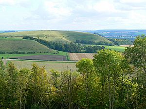
Scratchbury Camp is located on the edge of the chalk plateau known as Salisbury Plain. It's part of the "Norton Bavant Chalk Downland Edge" area. The hill offers wide views over the Wylye valley to the south.
Salisbury Plain is made of chalk rock. The landscape has shallow, well-drained soils over chalk on the slopes. The hills here are often steep where the chalk layers have been compressed.
The Norton Bavant Chalk Downland Edge has three distinct, steep hills: Middle Hill, Scratchbury Hill, and Cotley Hill. These hills form a unique area. They are mostly covered with long fields used for farming. There are also patches of natural chalk grassland and bushes on the hilltops. Many chalk grassland slopes in England show steps or stripes. These are formed by soil moving slowly and by sheep paths. You can see this on Scratchbury Hill. There are also patches of mixed woodland on the lower slopes.
Paths from the Imber military range run across the top of the hills. These paths allow public access to the area. However, it's important not to wander into the military firing ranges of Salisbury Plain nearby. The Cranborne Chase and West Wiltshire Downs Area of Outstanding Natural Beauty is to the south.
Nature and Wildlife
Scratchbury Camp is in an area of natural grassland on the edge of Salisbury Plain. This area has the largest remaining calcareous grassland in northwest Europe. This special grassland supports many different plants and butterflies. Because of this, it was made a Site of Special Scientific Interest in 1951. The site, called Scratchbury & Cotley Hills SSSI, covers about 53.5 hectares (132 acres). To keep the plants healthy and control the growth of shrubs, sheep need to graze here regularly.
The grassland is mostly made up of sheep's fescue, red fescue, and upright brome grasses. There are also many types of herbs typical of the Wiltshire downland. These include devil's bit scabious, saw-wort, and chalk milkwort. You can also find many other native plants, like orchids, meadow grasses, and nettles. On the steep slopes, horseshoe vetch, Thymus, and Asperula grow in large amounts.
Inside the hillfort, the grassland is a bit different. This is likely because of past farming. There are also small areas of hawthorn and elder scrub. These bushes are especially found on the lower slopes and earthworks. They provide important shelter for invertebrates (insects and other small creatures) on this open site.
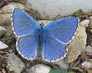
The site is very important for insects. Twenty-nine different types of butterflies have been recorded breeding here. The horseshoe vetch plant supports the chalkhill blue and Adonis blue butterflies. Other butterflies found here include the Duke of Burgundy, grizzled skipper, dark green fritillary, and small blue.
Other insect groups have not been studied as much. However, some rare species have been found. These include six types of weevils, eight types of plant bugs, and two types of chrysomelid beetles. These beetles feed on the rock rose plant. Day-flying moths like the wood tiger and the rare forester moth have also been seen. Small mammals like rabbits and badgers are common in the area.
Poetry Inspired by Scratchbury Camp
The famous English poet and author Siegfried Sassoon (1886–1967) lived nearby. In June 1942, he wrote a poem about Scratchbury Camp. His poem captures the peaceful feeling of the Wiltshire Downs on a summer day. It also mentions the military presence of that time and the timeless history of the area.
Along the grave green downs, this idle afternoon,
shadows of loitering silver clouds, becalmed in blue,
bring, like unfoldment of a flower, the best of June.
Shadows outspread in spacious movement, always you
have dappled the downs and valleys at this time of year,
while larks, ascending shrill, praised freedom as they flew.
Now, through that song, a fighter squadron's drone I hear
from Scratchbury Camp, whose turfed and cowslip'd rampart seems
more hill than history, ageless and oblivion-blurred.
I walk the fosse, once manned by bronze and flint head spear;
on war's imperious wing the shafted sun ray gleams:
one with the warm sweet air of summer stoops the bird.
Cloud shadows, drifting slow like heedless daylight dreams,
dwell and dissolve; uncircumstanced they pause and pass.
I watch them go. My horse, contented, crops the grass.—Siegfried Sassoon, On Scratchbury Camp, as published in 'The Best Poems of 1943'.
 |
Battlesbury Camp hillfort | Bratton castle | Casterley Camp hillfort |  |
| Cley Hill fort | White Barrow, Robin Hood's Ball Neolithic Camp, Knook Castle | |||
| Whitesheet Castle hillfort | Settlements at Great Ridge | Stonehenge, Codford Circle, Yarnbury Castle |
 | Victor J. Glover |
 | Yvonne Cagle |
 | Jeanette Epps |
 | Bernard A. Harris Jr. |


