
Knook Castle facts for kids
 |
|
| Lua error in Module:Location_map at line 420: attempt to index field 'wikibase' (a nil value). | |
| Location | Wiltshire |
|---|---|
| Region | Southern England |
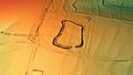
| Type | sub-rectangular univallate hillfort |
| Area | 1.75 hectares (4.3 acres) |
| History | |
| Material | Chalk |
| Periods | Iron Age |
| Site notes | |
| Archaeologists | Sir Richard Colt Hoare, William Cunnington, Petrie, Grinsell |
| Public access | footpaths |
Knook Castle is an ancient site in Wiltshire, England. It's known as an Iron Age hillfort, which was like a fortified village built on a hill. People in the Iron Age (around 800 BC to AD 43) built these for protection. Knook Castle is shaped roughly like a rectangle and has one main entrance.
Some experts also think it might have been a place to keep cattle safe. This would have been linked to nearby Romano-British settlements, which were villages where Romans and native Britons lived together.
In the past, people like John Marius Wilson described Knook Castle as an old camp. They believed it was first a British village and later a Roman summer camp. Old Roman coins have even been found here! Sir Richard Hoare, an early archaeologist, noted that you could still see traces of houses and old paths. Many ancient burial mounds, called tumuli or barrows, are also found nearby.
Today, you can easily visit the site and the surrounding hills using public footpaths. The Imber Range perimeter path runs right next to it. Further north is the Imber Range, a military training area on Salisbury Plain.
Ancient Villages: Romano-British Settlements


Not far from Knook Castle, about 300 meters north, are the remains of two ancient villages. These are called Knook Down East and Knook Down West. They were home to people during the Roman times in Britain. These two villages are about 600 meters apart and were connected by an old trackway.
Knook Down East was a village covering about 4 hectares (10 acres). It's still quite well-preserved, with a main path running through it and about 11 platforms and enclosed areas where houses might have stood.
Knook Down West was larger, covering about 11 hectares (27 acres). It might have been two separate settlements joined together. It had several trackways leading to different enclosed areas. Between these two parts was a field system, where people grew crops.
Archaeologists have found many interesting items at these sites, mostly from the 2nd to 4th centuries AD. These finds include bones, bracelets, nails, Roman coins, stone flooring, and parts of hearths (fireplaces). They even found burial remains with a basalt axe!
Other features in the area suggest a busy ancient landscape. There are old field systems, boundary earthworks (like ancient fences), ponds, and even two kilns for drying corn. There's also a possible small amphitheatre, which was a place for public shows.
Uncovering the Past: Archaeology
Archaeologists have dug up many fascinating objects at Knook Castle and the surrounding areas. These finds come from different time periods, including the Neolithic (New Stone Age), Bronze Age, Iron Age, and Romano-British times. Most of these amazing discoveries are now kept at the Wiltshire Museum in Devizes.
In the 1950s, an archaeologist named Leslie Grinsell studied and mapped the site. Even earlier, in the 1800s, Sir Richard Colt Hoare and William Cunnington carried out important excavations. They found many objects and burials. However, back then, the "three-age system" (dividing history into Stone, Bronze, and Iron Ages) hadn't been invented yet. This made it harder for them to figure out the exact age of their finds.
Many ancient burial mounds, called tumuli or barrows, are found near Knook Castle. These mounds were used to bury people long ago. Archaeologists have found various things inside them, like burial urns, bronze daggers, and even cremated bodies. Some barrows contained multiple burials, including some thought to be from later Saxon times. These discoveries help us understand how ancient people lived and buried their dead.
Images for kids
-
3D view of the digital terrain model

