
Durrington Walls facts for kids
|
Map showing Woodhenge and Durrington Walls within the Stonehenge section of the Stonehenge and Avebury World Heritage Site
|
|
| Location | OS SU150437 |
|---|---|
| Region | Wiltshire |
| Coordinates | 51°11′33″N 1°47′12″W / 51.1925°N 1.786667°W |
| Type | henge |
| History | |
| Periods | Neolithic |
| Site notes | |
| Excavation dates | 1966-7, 2003- |
| Archaeologists | G.J. Wainwright, Stonehenge Riverside Project |
| Condition | eroded banks and ditch |
| Public access | Yes |
| Website | National Trust |
| Designated | 1986 |
| Reference no. | 373 |
| Designated | 1929 |
| Reference no. | 1009133 |

Durrington Walls is a very old place in Wiltshire, England. It was once a huge village from the Neolithic period, also known as the Stone Age. Later, it became a special circular area called a henge.
This important site is part of the famous Stonehenge World Heritage Site. You can find it about 2 miles (3 km) northeast of Stonehenge, near the town of Amesbury.
Contents
Discovering Ancient Life at Durrington Walls
Archaeologists have been working hard to learn about Durrington Walls. In 2013, a team found something amazing. They uncovered evidence of a massive ancient village.
A Huge Stone Age Village
This village was truly enormous for its time. Researchers believe it had about 1,000 homes. This means it could have supported a population of up to 4,000 people. Scientists used a method called carbon dating to figure out its age. They found the village was built around 2600 BC.
The Largest Neolithic Settlement
Experts say Durrington Walls is the biggest Stone Age village ever found in northern Europe. It shows how many people lived together back then. The henge itself is also huge, measuring 500 meters across. It is the largest henge in all of Britain.
Durrington Walls and Stonehenge
Many researchers think Durrington Walls was closely connected to Stonehenge. They believe it was a "complementary monument." This means it worked together with Stonehenge for ancient rituals or events.
Mapping the Hidden Landscape
A special group called the Stonehenge Hidden Landscapes team has been mapping the area. They use advanced tools like remote sensing and geophysical imaging. These tools help them see what's underground without digging. This five-year project has revealed many secrets.
Hidden Stones Beneath the Ground
In 2015, the team found something incredible. About three feet under Durrington Walls, there are remains of around 90 standing stones. These stones are in a slightly curved line. Scientists used ground-penetrating radar to find them. They are still trying to figure out if these hidden stones are as old as early Stonehenge.
What You Can See Today
Today, what you mostly see of Durrington Walls are its 'walls.' These are actually the remains of the henge monument's banks. They form a ridge around a central area.
The Henge Structure
Originally, the ditch around the henge was very deep, about 5.5 meters (18 feet). It was 7 meters (23 feet) wide at the bottom and 18 meters (59 feet) wide at the top. The bank was also very wide, up to 30 meters (98 feet) in some places. There were two main entrances through the bank and ditch. These were at the northwest and southeast ends.
Inside the Henge
Inside the henge, there were several timber circles. These were circles made of large wooden posts. There were also smaller enclosed areas. Not all of these have been fully explored by archaeologists. Many ancient house floors have been found near and under the eastern bank of the henge. This suggests that a very large village once stood on the sloping river bank here.

Images for kids
-
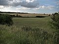
Durrington Walls, as seen from the south of the monument. It is bisected here to the left by one of the two roads that now cross the prehistoric site.
-
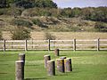
Durrington Walls, seen from Woodhenge
-
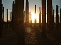
Sunrise at the Durrington Walls reconstruction, which was produced for a special episode of Time Team that first aired in 2005.


See also
 In Spanish: Muros de Durrington para niños
