River Boyd facts for kids
Quick facts for kids Boyd |
|
|---|---|

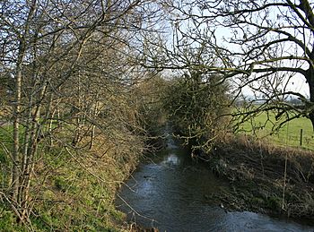
The River Boyd at Doynton, South Gloucestershire, England
|
|

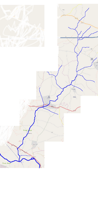
Diagrammatic map of the River Boyd and tributaries in South Gloucestershire
|
|
| Country | England |
| Region | West Country |
| District | South Gloucestershire |
| City | Bristol |
| Physical characteristics | |
| Main source | Springs Farm Dodington, South Gloucestershire, England 427 ft (130 m) 51°30′04″N 2°22′02″W / 51.5011°N 2.3673°W |
| River mouth | Bristol Avon Bitton, South Gloucestershire, England 49 ft (15 m) 51°25′01″N 2°27′39″W / 51.4170°N 2.4608°W |
| Length | 7 mi (11 km), south |
| Basin features | |
| Tributaries |
|
| River system | Bristol Avon |
The River Boyd is a small river, about 7 miles (11 km) long, located in South Gloucestershire, England. It starts near Dodington and flows south. The River Boyd is a branch, or tributary, of the Bristol Avon. It joins the Avon river near the village of Bitton.
On average, about 19.8 cubic feet per second (0.56 m3/s) of water flows through the River Boyd at Bitton. This river was even mentioned in a poem from 1613! The poem, called The Secrets of Angling, was written by John Dennys. It's one of the oldest English poems about fishing.
Long ago, people used the river's power to run watermills. These mills helped with different jobs, like at the Wick Golden Valley Ochre Works. Today, the area where the works used to be is a special nature reserve. The river and its valley are now part of a protected area for nature.
Contents
Where the River Boyd Flows
The River Boyd begins from springs near Sands Farm, just south of Dodington Chase. As it flows, several small streams join it from the right side. These streams come from springs on a high ridge of land to the north.
The river then goes under the M4 motorway. More streams from the Codrington area join it. Before reaching Doynton, other streams from Dyrham add to the river on its left side.
The Feltham Brook joins the River Boyd from the right, coming from Pucklechurch. This happens near Doynton House. The river then flows under Cleeve Bridge and enters a steep area called Golden Valley. This valley is now a nature reserve.
After passing under Boyd Bridge in Wick, the river turns south. It flows next to a long walking path called the Monarch's Way. The River Boyd leaves Golden Valley just north of Bitton. It then winds through river meadows before joining the Bristol Avon. This meeting point is close to where the Bristol and Bath Railway Path crosses the Avon.
History of the River Boyd Area
For many years, people mined ochre in Golden Valley near Wick. Ochre is a type of clay mixed with iron oxide, which gives it a yellow color. The Wick Golden Valley Ochre Works operated from the late 1800s until 1970. The leftover mining material made the water bright yellow, which is why it was called Golden Valley.
To help the watermills crush the mined ochre, a reservoir and a lake were built. People also dug for limestone and Millstone Grit in the area. Coal was mined underground too. The river's water power was used for many mills. Most of these mills ground corn, but some were for other industries. These included iron works and a paper mill. Over time, parts of the river were straightened. Many dams and weirs were also built across it to control the water.
Wildlife and Nature
The Wick Golden Valley Local Nature Reserve is part of a bigger natural area. This area is known as "Wick Rocks and the River Boyd." It has different types of habitats. These include calcareous grassland, which has alkaline soil. There are also broadleaved woodlands, the river itself, and plants growing along its banks.
You can find various plants here, such as Common Cow-wheat and Bitter Vetch. Other plants include Black Spleenwort, Harebell, Nettle-leaved Bellflower, Bluebell, and Viper's Bugloss.
Many animals also live in this area. You might spot a tiny moth called Pammene trauniana. Birds like dippers, kingfishers, and buzzards fly around. Otters and bats live near the river. You can also see beautiful damselflies.
What's in a Name?
The name Boyd is thought to come from an old British Celtic word. This word means "virtue, favour, blessing, or benefit." Some people believe this suggests that the river's waters might have had healing qualities long ago.
How Much Water Flows?
The Environment Agency has a special station at Bitton that measures the river's flow. They record that the River Boyd has an average flow rate of 19.8 cubic feet per second (0.56 m3/s). The highest flow ever recorded was 978.8 cubic feet per second (27.72 m3/s) on May 30, 1979. The lowest flow was 0.35 cubic feet per second (0.0099 m3/s) on August 16, 1976.
 | James Van Der Zee |
 | Alma Thomas |
 | Ellis Wilson |
 | Margaret Taylor-Burroughs |

