
River Marden facts for kids
Quick facts for kids River Marden |
|
|---|---|

|
|
| Country | United Kingdom |
| Region | Wiltshire |
| Physical characteristics | |
| Main source | Ranscombe Bottom Calstone Wellington, near Calne, Wiltshire 328 ft (100 m) 51°24′56″N 2°0′48″W / 51.41556°N 2.01333°W |
| River mouth | Bristol Avon near Chippenham, Wiltshire 151 ft (46 m) 51°27′56″N 2°05′33″W / 51.46556°N 2.09250°W |
| Length | 7 mi (11 km) |
| Basin features | |
| Tributaries |
|
The River Marden is a small river in England. It flows into the Bristol Avon. The Marden starts in the hills near Calne, a town in Wiltshire. It then flows for about 7 miles (11 km) before joining the Bristol Avon. This meeting point is about 1 mile (1.6 km) upstream from the town of Chippenham. On average, the Marden carries about 43 cubic feet per second (1.2 m3/s) of water.
Contents
River Marden's Journey
The River Marden begins its journey just north of a valley called Ranscombe Bottom. This area is close to Calstone Wellington in Wiltshire.
Flowing Through Towns and Parks
From its start, the river flows towards the northwest. It passes through beautiful places like Blacklands Park. Then it reaches the village of Quemerford. Here, another small stream called the Rivers Brook joins the Marden from the right side.
When the Marden reaches the town of Calne, the Abberd Brook also flows into it from the right. At this point, the river changes direction and flows west. Water from Bowood Lake, which is part of the Bowood House estate, also joins the Marden. This happens at a place called Studleybrook Farm.
Joining Other Streams
Further along its path, the Marden is joined by two more streams. These are the Fishers Brook and the Cowage Brook, which combine before meeting the Marden. The river then turns again, heading northwest. It flows past the village of Stanley.
After flowing for another 1.5 miles (2.4 km), the River Marden finally reaches its end. It joins the larger Bristol Avon to the northeast of Chippenham.
History of the River Marden
The River Marden has played an important role in the local area for a very long time.
Old Watermills
Back in 1086, a big survey of England called the Domesday Book was made. This book recorded that there were four watermills on the Marden in Calne. Watermills use the power of flowing water to turn machinery.
Later, in the 1700s, four "fulling mills" were recorded. Fulling mills were used to clean and thicken wool cloth. One of these mills, called Upper Mill, became a paper mill in 1768. It continued to make paper until 1860. Another mill, Hassell's Mill at Studley, worked even longer, until 1960.
The Wilts & Berks Canal
In 1810, a canal called the Wilts & Berks Canal was opened. This canal ran right next to the River Marden, west of Calne. Canals are like artificial rivers built for boats to travel on.
However, the canal was closed in 1914. This happened after a part of it, the Stanley aqueduct, collapsed into the river in 1901. An aqueduct is like a bridge that carries water. You can still find some parts of the old canal today.
River Flow and Measurements
Scientists and engineers keep track of how much water flows in rivers. This is called hydrology.
Measuring the Marden's Flow
The Environment Agency has a special station at Stanley. This station measures the flow of the River Marden. They have found that the river's average flow is 43 cubic feet per second (1.2 m3/s).
The highest flow ever recorded was 1,529 cubic feet per second (43.3 m3/s). This happened on October 30, 2000. The lowest flow recorded was 3.9 cubic feet per second (0.11 m3/s). This was on August 21, 1976. These measurements help us understand how the river changes over time.
Images for kids
-
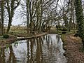
The Marden in the grounds of Blackland House, upstream of Calne

