New Cut, Bristol facts for kids
Quick facts for kids New Cut, Bristol |
|
|---|---|

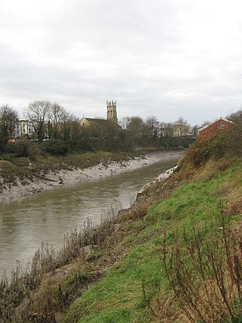
The river Avon, in the New Cut, looking west towards Southville and St Pauls church, Bedminster
|
|
| Country | England |
| State | Bristol |
| Physical characteristics | |
| Main source | River Avon Netham Weir, Bristol, England 27 ft (8.2 m) 51°27′06″N 2°33′09″W / 51.45167°N 2.55250°W |
| River mouth | River Avon Rownham, Bristol, England 9 ft (2.7 m) 51°26′53″N 2°37′30″W / 51.44806°N 2.62500°W |
| Length | 3.2 mi (5.1 km) |
| Basin features | |
| Tributaries |
|
The New Cut is an artificial waterway in Bristol, England. It was built between 1804 and 1809 to change the path of the tidal River Avon. This big project helped create Bristol's Floating Harbour. The engineer in charge was William Jessop.
The New Cut starts at Totterdown Basin, near Temple Meads. It flows all the way to the Underfall sluices at Rownham in Hotwells. There, it joins back with the original tidal River Avon.
The New Cut itself is about 1.8 miles (2.9 km) long. If you add short parts of the original river at each end, the whole water route is about 3.2 miles (5.1 km). Ships haven't used the New Cut regularly since the 1930s. However, smaller boats can still travel carefully as far as Netham weir.
Contents
Building the New Cut: A Big Project
The Bristol Docks Company was formed to build the Floating Harbour. This happened after a special law was passed in 1803. The City Corporation (Bristol's local government) and the Society of Merchant Venturers (a group of important business people) supported this law.
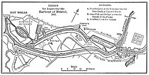
The engineer, William Jessop, first suggested a smaller plan. This plan would have made a shorter cut from Prince Street to Rownham. But this might have let ship owners avoid using the new Floating Harbour. So, the plan was changed to include a larger part of the River Avon. This meant building the longer New Cut we see today.
Starting the Digging Work
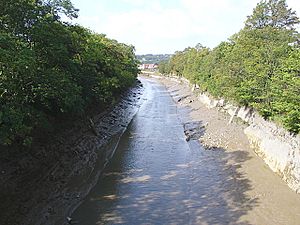
Work on the New Cut began on May 1, 1804, very early in the morning. The directors of the Bristol Docks Company held a special ceremony. Workers dug through Redcliffe Sandstone, a type of rock from the Triassic period. You can still see this rock in the cuttings along the New Cut.
There's a local story that French prisoners of war helped with the digging. However, there is no real proof to support this idea.
Costs and Challenges
A report showed that in the first year, workers removed 780,625 cubic yards (596,831 m3) of earth and rock. This cost a lot of money: £120,138 12s. 1d. The first guess for the whole docks project was £300,000. But this wasn't enough! More laws had to be passed to raise the money to £600,000.
The River Avon was moved into the New Cut in January 1809. On April 2, the first ships sailed up the New Cut. They then entered the harbour at the Bathurst Basin.
A Celebration and a Riot
On May 1, 1809, the docks project was officially finished. A big celebration dinner was held on Spike Island. A thousand navvies (the workers who built it) were invited. They ate "two oxen, roasted whole, a proportionate weight of potatoes, and six hundredweight of plum pudding." Each man also got a gallon of strong beer.
When the beer ran out, a disagreement started between English and Irish workers. This turned into a large fight. It had to be stopped by the press gang, who were like a police force at the time.
How Boats Used the New Cut
Originally, boats could travel all the way along the New Cut to Totterdown basin. From there, barges could enter the Feeder Canal. They could then go upriver from Netham lock to Bath. Another lock further downstream allowed ships to enter Bathurst Basin and then the Bristol Floating Harbour from the New Cut.
Shipyards and Bridges
Shipyards (places where ships are built) appeared along the New Cut in the 1800s. Acraman's had a yard in St Philip's Marsh by 1839. They built special chain-propelled floating bridges there. These bridges were too wide for the Floating Harbour.
Acraman's opened a second, larger yard in Bedminster the next year. This yard built many early steam ships. The first yard was used for shipbuilding until 1874. The second yard was taken over by John Payne Ltd in 1862. This Vauxhall Yard launched many small vessels directly into the New Cut until it closed in 1925.
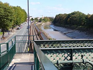
Until the 1930s, packet boats (ships carrying passengers and mail) ran regular services. They went from Bathurst Basin to Cardiff and Swansea across the Severn Estuary. Because of this, the first two bridges over the New Cut (the Vauxhall Bridge and Ashton Swing Bridge) were originally swing bridges. This meant they could open to let large ships pass. The third bridge, the Gaol Ferry Bridge, was built in 1935. Around the same time, the two swing bridges were permanently fixed in place.
Changes Over Time
The two smaller locks connecting the New Cut to the Floating Harbour (Bathurst and Totterdown) were filled in during World War II. Authorities were worried that if bombs hit the locks during the Bristol Blitz, all the water in the harbour would drain out. You can still see the remains of these filled-in locks today.
Because of these changes, the New Cut is still deep enough for medium-sized boats. The bridges are also high enough. However, it's now a dead end at Netham Weir. No businesses use it for water access anymore.
Few boats have traveled the New Cut since the swing bridges and smaller locks closed. Sometimes, there are inspection trips to check the bridges. Tourist trips from the Floating Harbour also happen occasionally. In the summer of 2009, special trips celebrated the 200th anniversary of the New Cut. Canoeists also use the cut regularly.
In 1992, the Bristol Development Corporation got a special Act of Parliament. This law would have allowed them to build a new weir across the New Cut. This weir would have kept the water level constant above that point. It would have helped develop the land nearby. However, these plans were never carried out, and the weir was never built.
 | Jessica Watkins |
 | Robert Henry Lawrence Jr. |
 | Mae Jemison |
 | Sian Proctor |
 | Guion Bluford |


