River Trym facts for kids
Quick facts for kids River Trym |
|
|---|---|

|
|

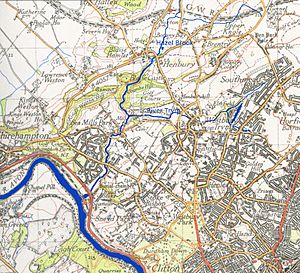
River Trym and Hazel Brook within Bristol
|
|
| Country | England |
| District | Bristol |
| City | Bristol |
| Physical characteristics | |
| Main source | Filton Bristol, West of England, England 250 ft (76 m) 51°30′43″N 2°35′17″W / 51.512°N 2.588°W |
| River mouth | River Avon (Bristol) Sea Mills, Bristol, England 33 ft (10 m) 51°28′50″N 2°39′02″W / 51.480474°N 2.650537°W |
| Length | 4.5 mi (7.2 km) |
| Basin features | |
| Tributaries |
|
| River system | Bristol Avon |
The River Trym is a small river in England. It is about 4.5 miles (7.2 kilometers) long. The river starts in Filton, South Gloucestershire. It flows through parts of Bristol before joining the River Avon.
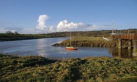
Much of the Trym flows underground in pipes, especially in city areas. But it also runs through pretty nature spots and city parks. Near its end, it meets the tidal River Avon at a place called Sea Mills. This area got its name from water mills that were there long ago.
Long ago, the Romans had a port called Portus Abonae at the mouth of the Trym. This port was a starting point for trips across the River Severn to South Wales. Later, people tried to build a port and even a whale fishing business here, but they did not last long. The name Trym might come from an old Anglo-Saxon word meaning 'strong'. In recent years, the river has had problems with silt (mud and sand) building up. This is due to buildings being built nearby. Work has been done to help fix this problem.
River's Journey
The River Trym begins near Filton in South Gloucestershire. It starts close to the Filton Golf Club. For much of its early journey, the river flows in underground pipes. These pipes are hidden beneath houses built in the 1900s.
The river then comes out into the open in Southmead, a part of Bristol. Here, it flows through a special place called Badock's Wood nature reserve. Just south of this area is Henleaze Swimming Lake. This lake used to be a quarry and is fed by natural springs. Any extra water from the lake flows into the Trym.
The river goes underground again as it passes through Westbury-on-Trym village. There is a special gate called a sluice here. It helps move water into a storm drain when there is a lot of rain. This stops the village center from flooding.
The Trym then disappears into pipes once more. It reappears at Henbury Golf Club. After this, it enters the beautiful Blaise Castle area. Here, another stream called the Hazel Brook joins the Trym. You can still see parts of an old mill, Coombe Mill, which used water from both streams.
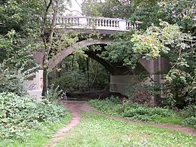
The river then flows under Dingle Road bridge. It continues through the Sea Mills river park. It passes under the Portway road and the Severn Beach railway line. Finally, it joins the River Avon. A small dam, called a weir, under the Portway helps stop flooding upstream. This only changes during very high spring tides.
Nature and Wildlife
Badock's Wood in Southmead is a special nature reserve. Bristol City Council helps manage it. This area has many trees like beech, oak, and ash. Other smaller trees and bushes like hazel and hawthorn also grow here.
Badock's Meadow used to have temporary houses. Now, it has been replanted with wild meadow flowers. You can see flowers like oxeye daisies and wild carrot. Many woodland birds live here, including woodpeckers and owls. You might also spot small bats called pipistrelles.
The Blaise Castle estate has many different kinds of trees and plants. It is also a home for birds and small animals. Further down the river, near Sea Mills, you can find some plants that are not native to the area. These include Himalayan Balsam and Japanese Knotweed. These plants can take over and cause problems for native plants.
You can often see ducks and moorhens along the river. Near where the river meets the Avon, you might see gulls and other birds that live near the sea. Sometimes, there have been problems with pollution in the river. This has harmed fish and other small creatures living in the water.
River History

Where the River Trym meets the Avon, there was once a Roman port and small town. It was called Portus Abonae. This name came from the River Avon, which simply means 'river' in the old British Celtic language. Abona was an important stop for the Roman army when they invaded Wales. It was also the end of a Roman road that started in Silchester.
In the 1400s, there were tide mills near the river's mouth. These mills used the power of the tides to grind grain. In 1712, a businessman named Joshua Franklyn tried to open a trading dock at the mouth of the Trym. This was in the same spot as the old Roman port. However, his business did not last very long. A whale fishing company also started there in 1752, but it also closed down quickly. You can still see parts of the old dock walls today.
What's in a Name?
Experts who study languages think the name Trym comes from an old Anglo-Saxon word. It might mean 'firm' or 'strong one'.
River Flow
The amount of water flowing in the River Trym has become less powerful recently. This is partly because of water running off from areas like the large shopping center at Cribbs Causeway. This water carries a lot of silt (mud and sand) into the river. This slows down the river's flow. It also increases the risk of flooding further downstream.
To help with this problem, a special reservoir was built near Cribbs Causeway. It is called the Catbrain attenuation reservoir. This reservoir helps to hold back some of the water. Measurements by the city council show that the river water is quite clean.
 | Claudette Colvin |
 | Myrlie Evers-Williams |
 | Alberta Odell Jones |

