Portway, Bristol facts for kids
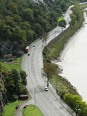
The Portway is a very important road in the city of Bristol, England. It is part of the A4 main road. The Portway connects Bristol city centre to the Avonmouth Docks and the M5 motorway. It runs through the beautiful Avon Gorge.
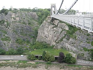
This road was built after World War I (around 1919-1926). It helped people get to the ports at Avonmouth Docks much more easily. These docks had become more important than Bristol Harbour for big ships. When it opened on July 2, 1926, the Portway was the most expensive road project in Britain. It cost £800,000, which is like £33 million today! Building it was very hard because of the rocky gorge. Engineers had to cut through deep rock and build bridges. Sometimes, rocks still fall onto the road, especially near the Clifton Suspension Bridge. Special concrete covers were built to protect cars from falling rocks.
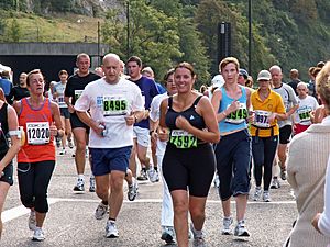
Today, the Portway is still a key route for Bristol. It is even used for the Portway Park and Ride bus service. Sometimes, the road is closed to cars for special events. These include the Bristol Half Marathon or times when people can enjoy the Avon Gorge without traffic.
Contents
What is the Portway's Route?
The Portway is about 5 miles (8 km) long. Many people think it starts in Hotwells. However, it actually begins where Bridge Valley Road and Hotwell Road meet. This spot is right below the famous Clifton Suspension Bridge. The road then follows the Avon Gorge, running next to the River Avon.
It goes through areas like Sea Mills and Shirehampton. In Sea Mills, it crosses the River Trym. The Portway ends at a roundabout in Avonmouth. Here, it connects with the M5 motorway and the A403 road.
For most of its length, the Portway is very close to the Severn Beach Line railway. The Sea Mills and Shirehampton train stations are nearby. However, you cannot get to the Portway directly from them. First Bus runs the Portway Park and Ride service. This bus also helps people travel through some of the nearby towns.
How Was the Portway Built?
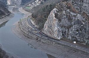
The Bristol Corporation (like the city council) planned the Portway. They did this because Bristol Harbour was not as busy as it used to be. The Avonmouth Docks could handle bigger ships. So, a new road was needed to reach them. Building started in May 1919. L. S. McKenzie was the main engineer.
Part of the new road near Clifton was built on an old railway line. The new road did not go right to Avonmouth Docks. Instead, it connected to an existing road near Shirehampton. There was a plan to build a tram line along the road. This would have linked Avonmouth to Bristol's tram system. But it was too expensive, so they did not build it.
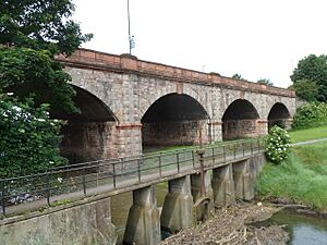
One of the biggest digging jobs was at Horseshoe Bend. This cut was 2,400 feet (730 m) long. It went 90 feet (27 m) deep into the rock at its deepest point. Further along, a bridge was needed to cross the River Trym. This bridge had six arches, each about 42 feet (12.95 m) long. Building this bridge was slow because of the river's tides and the uneven rock.
A special bridge was also built over the Severn Beach Railway near Sea Mills station. About 3,000 feet (910 m) of retaining walls were needed at the Bristol end. This was because the road was squeezed between the River Avon and the gorge wall. In September 1924, a new concrete wall slid into the river. This caused delays but no one was hurt.
The Portway officially opened on July 2, 1926. The Minister of Transport, Colonel Wilfrid Ashley, opened it with the Lord Mayor of Bristol, Alderman Moore. After a ceremony, they drove the whole length of the road. It was the most expensive road project in Britain at the time. It cost £800,000 (which is about £33,286,000 today). A lot of money was spent on the Horseshoe Bend cutting and the Trym bridge.
Electric lights were put in to light the new road. But for a year, they were kept off! River pilots said the lights made it hard to see the navigation lights of ships. Eventually, the lights were turned on, but not as brightly.
When it first opened, the Portway was called the A36. Later, on April 1, 1935, it became part of the A4 road.
Keeping the Portway in Good Shape
More cars started using the Portway when the M5 motorway was extended in 1971. This made it easier to avoid busy roads in north-west Bristol. Even though this was meant to be a temporary fix, building the Avonmouth Bridge was delayed. The Avonmouth Bridge finally opened in May 1974.
Rocks sometimes fall from the limestone cliffs of the Avon Gorge. This can be dangerous for drivers. Every year, the road is closed so workers can check the cliffs. They look for cracks and loose rocks and fix any problems. In 1980, a special concrete canopy was built. It covers the Portway where it goes under the Clifton Suspension Bridge. This helps protect cars from falling rocks.
In 2001, a large water pipe burst near Bridge Valley Road. This caused a big hole and closed the road for several months. One person was swept into the river but was rescued safely.
Other Things to Do on the Portway
The Portway Park and Ride is in Shirehampton, near the M5 motorway. There is a special bus lane on the road. This helps buses get to the city centre faster. A new train station at the Park and Ride was suggested in 2009. It opened on August 1, 2023.
The Portway is often closed to cars for other events. The yearly Bristol Half Marathon in September uses the Portway as part of its route. The annual Bristol's Biggest Bike Ride also uses the road. For this event, the road is closed to motor traffic for the day. After these sporting events, "Peaceful Portway" festivals take place. This allows visitors to enjoy the Avon Gorge scenery without any traffic.
In 2009, a city councillor suggested closing the Portway to cars on summer Sundays. This would let people cycle without traffic. In 2015, the Portway was closed for five Sundays in May and June. The Mayor of Bristol, George Ferguson, said this helped with Big Green Week. This is a festival that promotes eco-friendly activities in Bristol.
Fun Incidents
In 2014, a secret group built a funny sign next to the Portway. It was 8-foot-high (2.4 m) and looked like the Hollywood Sign. But it said "Bristoland"! People driving by really liked it. A few months later, the sign was briefly changed to "It's bland". No one knows why. After that, it was quickly taken down.
 | Emma Amos |
 | Edward Mitchell Bannister |
 | Larry D. Alexander |
 | Ernie Barnes |


