
Clifton, Bristol facts for kids
Quick facts for kids Clifton |
|
|---|---|
 Clifton (southwest, in red) and Clifton Down (northeast, in blue) city council wards shown within Bristol. |
|
| Population | 21,818 Both wards (2011) |
| OS grid reference | ST571737 |
| Unitary authority | |
| Ceremonial county | |
| Region | |
| Country | England |
| Sovereign state | United Kingdom |
| Post town | BRISTOL |
| Postcode district | BS8 |
| Dialling code | 0117 |
| Police | Avon and Somerset |
| Fire | Avon |
| Ambulance | Great Western |
| EU Parliament | South West England |
| UK Parliament |
|
Clifton is a well-known area in the city of Bristol, England. It is also the name of one of Bristol's thirty-five electoral wards, which are like local voting districts. This Clifton ward includes areas called Cliftonwood and Hotwells. Another part of Clifton, towards the east, is in a different ward called Clifton Down.
Clifton is famous for many things. It is home to the amazing Clifton Suspension Bridge, designed by Isambard Kingdom Brunel. Many buildings of the University of Bristol are here, including Goldney Hall. You can also find the Roman Catholic Clifton Cathedral, Christ Church, Clifton Down, and two well-known schools: Clifton College and Clifton High School. The Bristol Zoo used to be here too. Clifton is also known for the Downs, a very large open park perfect for outdoor activities.
Contents
What is Clifton's Geography Like?
Clifton does not have official borders, but people generally think of it as the high ground. This area stretches from Whiteladies Road in the east to the edge of the Avon Gorge in the west. It goes from Clifton Down and Durdham Down in the north down to Cornwallis Crescent in the south.
This area is similar to the Bristol City Council wards of Clifton and Clifton Down. However, there are some small differences. For example, the Clifton ward includes areas like Cliftonwood and Hotwells. The Clifton Down ward includes parts of Redland and Cotham.
Clifton has a few main spots where people gather. Whiteladies Road is a busy shopping area in the east. Clifton Village is a smaller shopping area closer to the Avon Gorge in the west.
A Look at Clifton's History
.jpg)
Clifton was first mentioned in the Domesday book, a very old survey from 1086. It was called Clistone, which means 'hillside settlement'. This name describes its location on a steep hill. Clifton was once a separate village located west of Bristol city centre. Over time, as Bristol grew, Clifton became connected to the city. This happened especially during the Georgian era (the 1700s and early 1800s), when many new buildings were constructed. Clifton officially became part of Bristol in the 1830s.
Clifton is one of Bristol's oldest and wealthiest areas. Many of its grand houses were built using money from the tobacco trade. These large homes needed many servants to help run them. Some houses were detached or semi-detached, meaning they stood alone or were joined to one other house. However, most were built as terraces, which are rows of identical houses joined together. Many of these had three or more floors.
One famous terrace is the beautiful Royal York Crescent. You can see it from the Avon Gorge below, looking out over the Bristol docks. Berkeley Square and Berkeley Crescent were built around 1790 and are great examples of Georgian architecture. There are also quiet squares like the triangular Canynge Square.
The Whiteladies Picture House on Whiteladies Road was a cinema. It closed in 2001 and became offices and a gym. But it reopened as a cinema again in 2016, run by Everyman Cinemas. The Clifton Lido was built in 1850 as a public swimming pool. It closed in 1990 but was redeveloped and reopened in November 2008.
How to Get Around Clifton: Transport

Clifton has its own train station, Clifton Down railway station. It is on the local Severn Beach railway line. Many buses also run frequently from central Bristol to Clifton. Roads connect Clifton to the city centre and to the western suburbs. You can also cross the famous Clifton Suspension Bridge to reach Leigh Woods in North Somerset. From 1893 to 1934, a special railway called the Clifton Rocks Railway connected Clifton to Hotwells.
Clifton's Natural History and Conservation Efforts
Clifton has a strong connection to natural history television and global conservation. This is because the Bristol Zoo used to be in the north of the area. Also, the BBC Natural History Unit is located on Whiteladies Road. This means that over 25% of the world's wildlife TV shows are made right here in Bristol!
The popular TV show Animal Magic, hosted by Johnny Morris, was filmed at Bristol Zoo from 1963 to 1983.
The UK office of Ape Action Africa, a charity that helps rescue and care for chimpanzees and gorillas in Cameroon, West Africa, also operates from Clifton.
Clifton Electoral Ward
| Clifton | |
|---|---|
| ward Bristol City Council. |
|

Ward boundaries since 2016.
|
|
| County | Bristol |
| Population | 13,022 |
| Electorate | 8,883 |
| Current ward | |
| Created | 1974 |
| Councillor | Paula O'Rourke (Green) |
| Councillor | Jerome Thomas (Green) |
| UK Parliament constituency | Bristol Central |
The Clifton electoral ward covers the central and southwestern parts of Clifton. It also includes Cliftonwood and the hillside areas of Hotwells, reaching as far south as Hotwells Road. This ward is represented by two people on the Bristol City Council. As of 2024, these representatives are Paula O'Rourke and Jerome Thomas. Both are members of the Green Party of England and Wales.
The Clifton electoral ward was first created in 1974. At that time, it elected one member to the Avon County Council and three members to the Bristol City Council. The boundaries of the ward were changed in 1980 and again in 2016.
| Elected | Councillor | Party | Electorate | Turnout | |
|---|---|---|---|---|---|
| 2024 | Paula O'Rourke | Green | 8,883 | 39% | |
| Jerome Thomas | Green | ||||
| 2021 | Katy Grant | Green | 9,845 | 48.57% | |
| Paula O'Rourke | Green | ||||
| 2016 | Paula O'Rourke | Green | |||
| Jerome Thomas | Green | ||||
Before 2016, Bristol City Council used a different election system. Councillors served for four years, but elections happened in three out of every four years. This meant that about one-third of the seats were up for election at a time. So, Clifton ward elected one of its two councillors every two years.
| Elected | Councillor | Party | |
|---|---|---|---|
| 2015 | Jerome Thomas | Green | |
| 2013 | Charles Lucas | Conservative | |
| 2011 | Barbara Janke | Liberal Democrats | |
| 2009 | Trevor Blythe | Liberal Democrats | |
| 2007 | Barbara Janke | Liberal Democrats | |
Famous People from Clifton
Many well-known people have lived in or been connected to Clifton:
- Angela Carter – a famous author who studied at the University of Bristol.
- Carla Denyer – a councillor for Clifton since 2015 and a co-leader of the Green Party of England and Wales.
- Eugénie de Montijo – who later became Empress Eugenie of France, wife of Napoleon III. She was a student in Royal York Crescent.
- Keith Floyd – a popular chef and TV personality.
- W. G. Grace – a legendary cricketer and surgeon.
- Francis Greenway – a famous Australian architect who designed The Clifton Club.
- John Grimshaw – the person who started Sustrans, an organization that promotes cycling in the UK.
- Sarah Guppy – an inventor who worked with Isambard Kingdom Brunel.
- Annie Kenney – a leading suffragette who fought for women's right to vote.
- Thomas MacAulay – a well-known historian.
- Peter Nichols – an actor and playwright who worked at the Bristol Old Vic.
- Peter O'Toole – a famous actor who began his career at the Bristol Old Vic.
- Svetlana Alliluyeva – also known as Lana Peters, she was the daughter of Joseph Stalin.
- Tom Stoppard – a very famous playwright.
- John Addington Symonds – a writer.
- Fabian Ware – the founder of the Commonwealth War Graves Commission.
- William West – an artist who built the Clifton Observatory.
Cliftonwood: A Part of Clifton

Cliftonwood is a smaller area within Bristol. It is bordered by Hotwells Road to the south and Jacob's Wells Road to the east. To the north, it is next to the gardens of Goldney Hall, which is a student residence for the University of Bristol. Because of the way the land is shaped, there are only two main roads to get in and out: Ambra Vale and Clifton Wood Road. However, there are many footpaths. Sometimes the name is spelled "Cliftonwood" (one word) and sometimes "Clifton Wood" (two words). Many people consider Cliftonwood to be part of Clifton.
Cliftonwood is mostly a place where people live. The only business there is the Lion pub. The houses are mainly large Victorian terraces. Many of them are painted in bright colours. If you stand by Bristol's harbour and look up at Cliftonwood, you can see the colourful backs of houses on Ambrose Road and Clifton Wood Terrace.
In 1987, a very old Jewish ritual bath, called a mikveh, was found in what used to be the Hotwells Police Station bicycle shed. This discovery is believed to be the origin of the name Jacob's Well, which is also the name of a nearby road.
Images for kids
-
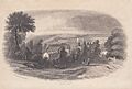
Clifton as seen from the Church, around 1840.

