
Coombe Dingle, Bristol facts for kids
Quick facts for kids Coombe Dingle |
|
|---|---|
 The Dingle, Coombe Dingle |
|

Coombe Dingle
|
|
| OS grid reference | ST552775 |
| Unitary authority | |
| Ceremonial county | |
| Region | |
| Country | England |
| Sovereign state | United Kingdom |
| Post town | BRISTOL |
| Postcode district | BS |
| Dialling code | 0117 |
| Police | Avon and Somerset |
| Fire | Avon |
| Ambulance | Great Western |
| EU Parliament | South West England |
| UK Parliament |
|
Coombe Dingle is a suburb in Bristol, England. It's a green and peaceful area where the Hazel Brook stream meets the River Trym. This spot is special because the stream comes out of a limestone gorge. This gorge cuts through the beautiful Blaise Castle Estate.
Coombe Dingle was once part of the old parish of Westbury on Trym. Now, it's part of the Kingsweston ward in Bristol. To the south, you'll find Sea Mills. To the north is Kings Weston Hill. West of Coombe Dingle are Kings Weston House and Shirehampton Park. To the east, you'll find Henbury Golf Club and Westbury on Trym itself.
Contents
What's in a Name?
The name "Coombe" means a 'short, bowl-shaped valley'. People have used this name since the 1200s. It appeared in old documents and on early maps. The name first referred to Coombe Farm and Coombe House. These were on the east side of where the Hazel Brook and River Trym meet. This area later became famous for its cherry orchards.
The name "Coombe Dingle" actually referred to the wooded valley. This valley is where the River Trym flows south-west. In the 1920s and 1930s, new homes were built here. These houses were mostly private and built on land called Boulton's Fields. The name of the valley was then used for this new neighborhood. It has always been a popular place to live.
A Popular Spot for Outings
Coombe Dingle was once a very popular place for people from Bristol to visit. There was a well-known tea-room and tea garden. It was located in the wooded Dingle itself. This tea-room was there by 1888 and was called Appletree Cottage. Today, it's a private house.
The original winding road, called The Dingle, has been replaced. A modern road, the A4162, now crosses the river on its own bridge. This bridge has a classical-style railing. Sylvan Way and the bridge were built around 1920. The bridge is made of concrete. It's an early example of using concrete to look like older brick and stone arches.
The River and the Mill
In the Dingle, the River Trym powered a flour mill. This mill was known as Coombe Mill.
-
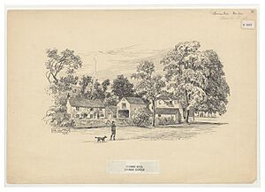
Coombe Mill in the Dingle. Pen drawing by Samuel Loxton (1857-1922). Credit: Bristol Reference Library.

Near Coombe House, there was a special system. A sluice, which is like a water gate, directed water. It sent water from the Trym into a mill stream. This stream then flowed to Hazel Brook. Another sluice could send water to the mill itself. This clever setup meant the mill could use water from both the River Trym and Hazel Brook. This was especially helpful when Hazel Brook's water level was low.
-
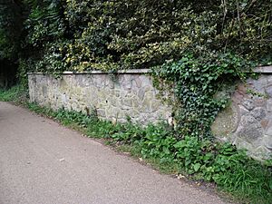
Millstones in a garden wall near where Coombe Mill used to be. Picture credit: Know Your Place web site.

Coombe House was located south of where the Trym and Hazel Brook meet. It was the home of John Graves Livingston. He was a director and chairman of the Ffestiniog Railway Company for a long time.
-
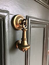
The brass knocker on the lodge of Coombe House.

Local Life and Facilities
You can find a row of shops on Westbury Lane. There used to be a small "tin" chapel nearby. This was a Methodist chapel made of corrugated iron. It had simple Gothic-style windows and was built in the 1890s. It was taken down in the mid-1990s and a house was built there instead. There are no other places of worship in Coombe Dingle itself.
Coombe Lane is also home to the Bristol University sports complex. Even though it's often called "Coombe Dingle sports complex," it's actually located in Stoke Bishop.
