Siston Brook facts for kids
Quick facts for kids Siston Brook |
|
|---|---|

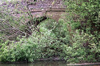
Londonderry Wharf Bridge crossing the Siston Brook as it joins the Bristol Avon
|
|

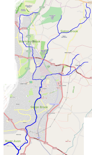
Diagrammatic map of the Siston Brook and tributaries in South Gloucestershire, England
|
|
| Other name(s) | Clack Mill Brook |
| Country | England |
| Region | South Gloucestershire |
| Physical characteristics | |
| Main source | Siston, South Gloucestershire, England 338 ft (103 m) 51°28′48″N 2°26′55″W / 51.4799°N 2.4487°W |
| 2nd source | Siston, South Gloucestershire, England 305 ft (93 m) 51°28′38″N 2°27′01″W / 51.4773°N 2.4503°W |
| River mouth | River Avon Londonderry Wharf, South Gloucestershire, England 35 ft (11 m) 51°25′36″N 2°29′18″W / 51.4268°N 2.4883°W |
| Length | 6 mi (9.7 km) |
| Basin features | |
| Tributaries |
|
| River system | Bristol Avon |
The Siston Brook is a small river in South Gloucestershire, England. It starts from two separate streams near the village of Siston. The brook is about 6 miles (10 km) long. It flows into the Bristol Avon.
Most of the Siston Brook flows through the eastern parts of Bristol. However, it stays just outside the city's official boundaries. Other streams, like the Warmley Brook, flow into it.
In the past, the Siston Brook helped power watermills. These mills were used for grinding grain and other industrial tasks. Today, some old mill buildings are still standing. The brook also flows through nature reserves. These areas help protect local wildlife. Sometimes, the brook has caused flooding. To prevent this, an "attenuation reservoir" was built. This reservoir helps control the water flow.
The name Siston is very old. It comes from an Anglo-Saxon word meaning "Sige's Farmstead."
Contents
Where Does Siston Brook Flow?
The Siston Brook begins as two springs. These springs flow out of a ridge just north of Siston village. The two streams join together near St Anne's church.
From there, the brook flows southwest. It passes through Overscourt Wood, which is a nature reserve. This wood is part of the Forest of Avon. A small stream joins the Siston Brook from the left near Webb's Heath Farm. Another stream joins from the right at Mill Farm. The brook then flows south through a steep valley. It reaches Warmley Forest Park. Sometimes, the upper part of the brook is called Clack Mill Brook.
The Warmley Brook then joins the Siston Brook from the right. It flows down from Rodway Hill. The Siston Brook then goes through Warmley. Part of it flows underground in a culvert. It continues south. Another stream from Bridgeyate Common joins from the left.
The brook then flows past Cadbury Heath and Oldland. It goes between the village and Oldland Common. It enters another nature reserve at Willsbridge Mill. Finally, it flows under the A431 road. It joins the River Avon at Londonderry Wharf. This wharf was once used to load coal from nearby mines onto boats.
How Siston Brook Was Used in the Past
Like other rivers in the area, the Siston Brook was very important for power. It powered watermills that ground corn. As the Industrial Revolution grew, the brook also powered machines for mining.
In the 1700s, a businessman named William Champion built a dam on the stream at Warmley. This created a large, 13-acre lake. It was part of the beautiful gardens at his home, Warmley House. This lake also stored water to power Champion's brass mills. Today, the lake is no longer there.
Weirs, pools, and sluices are structures that control water flow. These have been used in the upper parts of the brook for a long time. There are plans to fix many of them. This will help prevent flooding in the future.
An old water mill at Willsbridge was built in the 1700s. It worked until the 1960s. At first, it was used to mill iron. Later, in the early 1800s, it was changed to produce flour. The mill has been restored. It is now a key part of a nature reserve. This reserve is managed by the Willsbridge Mill Community Refresh group.
The place where Siston Brook meets the River Avon became a wharf in the 1700s. A wharf is a place where boats can load and unload goods. This wharf was used to load coal onto barges. The coal came from mines at Coalpit Heath. It was brought to the river on a special narrow railway called a "dramway." The dramway used gravity to move the coal carts.
Nature and Wildlife
The Siston Brook flows through several nature reserves. These include Overscourt Wood, Warmley Forest Park, and Willsbridge. These reserves are safe places for many animals and plants. You can find amphibians (like frogs and newts), different kinds of river birds, and various plant species living there.
What Does Siston Mean?
The name Siston has changed over time. It has been called Sistone, Syton, Sytone, and Systun. Experts believe the name comes from an old Anglo-Saxon phrase. It likely means "Sige's Farmstead." This tells us that people have lived in the area for a very long time.
How Siston Brook Helps with Flooding
In the 1990s, a major road called the Avon Ring Road was being built. During this construction, an "attenuation reservoir" was made in the Siston Common area. A reservoir is a large storage area for water. This one was built to help stop flooding. It collects extra rainwater during heavy storms. This prevents too much water from flowing into the brook at once.
 | Kyle Baker |
 | Joseph Yoakum |
 | Laura Wheeler Waring |
 | Henry Ossawa Tanner |

