Climate of south-west England facts for kids
The climate of South West England is mostly oceanic. This means it often has cloudy skies, cool winters, and cool summers. It rains throughout the year, but especially in winter. The region gets about 1000 mm (around 40 inches) of rain each year. Higher areas can get up to 2000 mm (about 80 inches) of rain. Some places, like Exeter, get less rain because they are in a "rain shadow" behind high ground.
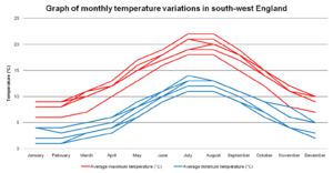
Summer temperatures usually range from 18°C (64°F) in the Isles of Scilly to 22°C (72°F) in the north-east. Winter temperatures usually range from 1°C (34°F) in the north-east to 5°C (41°F) in Cornwall and the Scillies. Very cold weather is rare, and temperatures almost never drop below -15°C (5°F). Long periods of very hot weather are also rare. However, in July 2022, temperatures reached 36°C (97°F) in Bude, and 33-35°C (91-95°F) in other inland areas.
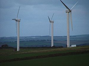
South West England is the second windiest part of the United Kingdom. Most winds blow from the south-west and north-west. Experts think this region will become the hottest part of the UK in the future.
Areas that are inland and not very high up get the least rain. They have the warmest summers but colder winters than the coast. Snow falls more often here than on the coast, but less than on high ground. These areas are also less windy and get a medium amount of sunshine. This kind of climate is more noticeable the further north-east you go.
Compared to inland areas, the coast has warmer minimum temperatures, especially in winter. Summer maximum temperatures are slightly lower. Coastal areas get the least rainfall, and snow is very rare. They are the windiest parts of the peninsula and get the most sunshine. This coastal climate is stronger the further south-west you go.
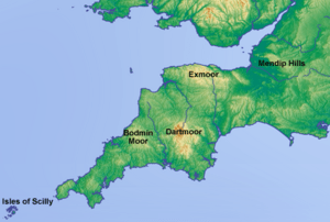
The south-west has high, open areas called moorland, like Bodmin Moor, Dartmoor, and Exmoor. Because they are high up, these moors are colder and get much more rain than other parts of the south-west. They also get the most snow and the least sunshine. Exposed parts of the moors are very windy, almost as windy as the coast.
Coastal areas get the most sunshine. This is because clouds that form from warm air rising tend to form a bit further inland. Places like Torquay, Falmouth, Newquay, and Ilfracombe get around 1700-1800 hours of sunshine a year. Inland areas like Yeovil, Tiverton, and Exeter are cloudier and often foggy, getting about 1450-1600 hours of sunshine.
Contents
What is South West England?
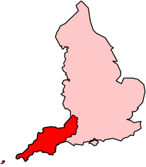
When we talk about the climate of South West England in this article, we are using the definition from the Met Office. This includes Cornwall, Devon, Somerset, North Somerset, Bath and North East Somerset, South Gloucestershire, the city of Bristol, and the Isles of Scilly.
This area is smaller than the "South West England" region used by the UK Government, which also includes Gloucestershire, Wiltshire, and Dorset. Sometimes, people also call this region the West Country.
Temperatures in the South West
The South West has different temperatures throughout the year, but these changes are not as extreme as in most of the UK. This is because the sea is closer to many inland areas here. The sea doesn't change temperature as much as land does.
The sea is coldest in February and March. Because of this, Cornwall and Devon are coldest in February. Daily low temperatures range from 1.5°C (35°F) in inland Devon to 5°C (41°F) on the Isles of Scilly. Further north-east, the sea has less effect, so January is the coldest month, with low temperatures around 1°C or 2°C (34-36°F).
In July and August, which are the hottest months, daily high temperatures range from about 19°C (66°F) on the coast of Cornwall to 22°C (72°F) in inland areas of the north-east (like Somerset and North Somerset). Exeter also gets warm because it's on the eastern side of Dartmoor.
The sea around the South West peninsula is the warmest in the UK, usually around 12-13°C (54-55°F). Coastal areas of Cornwall and the Isles of Scilly have similar average yearly temperatures to the sea because the wind often blows from the sea. As you go north-east, the average yearly temperature drops to just over 10°C (50°F).
The sea helps keep temperatures steady in west Cornwall, where the difference between summer and winter temperatures is about 9°C (16°F). In the north-east, this difference is about 12°C (22°F). Higher areas are colder; for example, Princetown on Dartmoor, which is 414 meters (1,358 feet) high, has an average temperature of 8°C (46°F).
The sea usually stops the South West from getting very cold. However, temperatures can drop sharply when cold air blows from the east. This has happened in January. In 1987, the lowest temperature recorded at St Mawgan, Cornwall, was -9°C (16°F). On the Isles of Scilly, it was -7.2°C (19°F). Inland areas have been even colder, with -15°C (5°F) at Exeter International Airport in 1958 and at Bastreet, Cornwall, in 1979. Further north-east, temperatures reached -16.1°C (3°F) in Yeovilton, Somerset, in 1982.
Very hot temperatures, called heat waves, are rare in the South West. They happen when dry, hot air blows from mainland Europe or during a "Spanish plume" event. A Spanish plume happens when a low-pressure system south-west of the UK and a high-pressure system over northern Europe pull hot air from Spain. This air picks up moisture over the Bay of Biscay, making it humid and uncomfortable.
With strong summer sunshine, temperatures can rise very quickly. The hottest temperature ever recorded in the South West was 36°C (97°F) on July 17, 2022, in Bude, Cornwall. Overnight, it can stay uncomfortably warm, sometimes not dropping below 19-20°C (66-68°F). When it stays above 20°C, it's called a "tropical night."
Sunshine in the South West
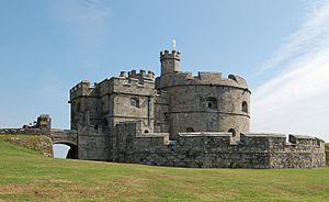
On average, coastal areas get over 1,600 hours of sunshine each year. The southern coast along the English Channel gets more sunshine than the northern coast along the Bristol Channel. Inland areas usually get between 1,400 and 1,600 hours of sunshine per year.
The sunniest month ever recorded was June 1925. Pendennis Point in Cornwall had 381.7 hours of sunshine, and Long Ashton in Somerset had 334.8 hours. In the winter months, which are the dullest, there have been times when less than 20 hours of sunshine were recorded in a whole month. For example, in December 1998, there were 20 days without sun at Yeovilton.
Generally, June is the sunniest month because the days are longest. December is the dullest. A high-pressure system called the Azores High often extends towards the UK, especially in summer. This high pressure reduces cloud cover, leading to more sunshine. In spring and summer, the sea is cooler than the air, which means fewer clouds form over the coast. These clouds tend to form more inland, especially over high ground like Dartmoor, Exmoor, and Bodmin Moor. This is why coastal areas of the South West get more sunshine.
Rainfall in the South West
Most of the rain in the South West comes from low-pressure systems moving across the Atlantic Ocean or from thunderstorms. In autumn and winter, the Atlantic low-pressure systems are very active and bring a lot of rain. In summer, much of the rain comes from the sun heating the ground, which causes air to rise, forming showers and thunderstorms.
The Isles of Scilly get about 850-900 mm (33-35 inches) of rain each year. Coastal areas of Cornwall and Devon usually get 900-1,000 mm (35-39 inches) of rain annually. The amount of rain increases with altitude. Higher areas are cooler, causing moist air to cool and form clouds and rain as it rises over the hills. For example, Princetown is 23 km (14 miles) from Plymouth and 403 meters (1,322 feet) higher, and it gets twice as much rain.
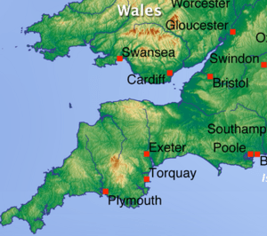
Areas in the "rain shadow" (on the sheltered side) of high ground get less rain. For instance, Exeter (east of Dartmoor) gets about 800 mm (31 inches) of rain, and parts of central Somerset (east of Exmoor) get about 700 mm (28 inches). The Mendip Hills in the north-east get over 1,100 mm (43 inches) per year, while the Bath–Bristol area gets around 800-900 mm (31-35 inches).
The sea is warmest in late summer and autumn, and coldest in late winter and spring. Because of this, the most rain usually falls in autumn, and the least in spring. The months with the most rainfall are generally in autumn and winter. The amount of rain each month can vary a lot. On the coast, some months have recorded less than 20 mm (0.8 inches) of rain, and sometimes even less than 10 mm (0.4 inches). Princetown, the wettest place in the region, has recorded as little as 7 mm (0.3 inches) of rain in May.
The number of rainy days (days with at least 1 mm of rain) follows the same pattern as the amount of rainfall. In late spring and summer, coastal areas have 9-10 rainy days per month. The north-east has 7-9 rainy days, and high-altitude areas like Princetown have 12-13 rainy days. In winter, these numbers increase: 15-16 rainy days on the coast, 12-13 in the north-east, and over 18 days in high-altitude areas.
Very heavy rainfall, lasting 5-15 hours, is rare in the South West. One example is the Lynmouth disaster on August 15, 1952. About 228 mm (9 inches) of rain fell locally on Exmoor in 12 hours. On June 8, 1957, 203 mm (8 inches) fell at Camelford, Cornwall. In June 1917, 243 mm (9.6 inches) fell in 13 hours in Bruton, Somerset.
The village of Boscastle in north Cornwall was flooded on August 16, 2004. At its peak, 80 mm (3.1 inches) of rain fell in one hour. About 100 people had to be rescued by helicopter, and 116 cars were washed out to sea.
From December 2013, the Somerset Levels experienced severe flooding. The Levels are a low-lying area, only about 3-4 meters (10-12 feet) above sea level, and have often flooded. Heavy rainfall in December 2013 and January 2014 caused widespread flooding. Over 600 houses and 17,000 acres of farmland were affected. The village of Thorney was abandoned, and Muchelney was cut off by water.
Snowfall in the South West
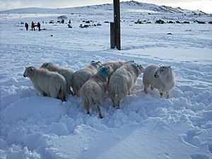
Snow usually falls between November and April. On higher ground, light snow can even fall between October and May. Snow usually only stays on the ground between December and March. Snow rarely falls when temperatures are above 4°C (39°F), and for it to settle, temperatures usually need to be below 4°C (39°F).
In the South West, the number of days with snowfall increases with altitude. For every 100 meters (328 feet) you go up, the number of snow days increases by about five days. From 1979 to 2000, the islands and coastal areas of Devon and Cornwall had fewer than 10 days of snow falling per winter. Near the Severn Estuary, it was slightly more than 10 days. Inland areas had between 8-15 days of snow, with more towards the north-east. Some upland areas had over 25 days of snow falling per year.
Similarly, the number of days when snow settles on the ground also increases by five days for every 100 meters (328 feet) of altitude increase. In the South West, it's rare for snow to settle. From 1979 to 2000, lowland areas had no lying snow in one out of every three years. During this time, snow settled for fewer than three days per year on the Isles of Scilly and the coasts of Devon and Cornwall. Inland areas had 5-10 days of lying snow per year, with more towards the north-east. On the high grounds of Dartmoor and Exmoor, you can expect more than 20 days of lying snow.
Even though the South West is the mildest region in the British Isles, it has experienced some very severe blizzards. Blizzards are rare in the UK. They can happen when very cold easterly winds from Europe meet an Atlantic low-pressure system, causing a long snowstorm with strong winds. This happened in February 1978. Inland Devon got 50 cm (20 inches) of snow, and Dartmoor and Exmoor got 90 cm (35 inches). This was caused by -2°C (28°F) winds blowing at 25 knots (46 km/h or 29 mph).
In January 1982, snow drifts were 1 meter (3.3 feet) deep around the Bristol area. On January 12, 1987, thunderstorms brought deep snow to parts of Cornwall: 35 cm (14 inches) at Falmouth, 39 cm (15 inches) at Penzance, and 23 cm (9 inches) on the Isles of Scilly.
Wind in the South West
The South West is the second most exposed area in the United Kingdom, after western Scotland. The strong winds are caused by large low-pressure systems moving across or near the British Isles. Winds are stronger in winter because these systems are more frequent and powerful then. The lightest winds are in summer. The strongest gusts and average wind speeds follow a similar pattern throughout the year.
Average wind speeds are generally lower in the north-east of the region and in inland areas. For example, Yeovilton in lowland Somerset has an average wind speed that is two-thirds of that at St. Mawgan in coastal Cornwall. In inland areas, wind speed generally increases with altitude. The highest parts of Exmoor and Dartmoor have similar wind speeds to the coast.
Most of the strongest winds come from the south-west and north-east. This happens as Atlantic low-pressure systems move from west to east over the UK. When a low-pressure system reaches the UK, winds usually blow from the south or south-west. They change to west or north-west as the system moves away. If a low-pressure system passes along the English Channel, strong winds can come from the east or north-east. In spring, most winds come from the north-east due to high pressure over Scandinavia.
Coastal areas of the South West usually have calm or very light winds less than 6% of the time. This figure is 15% in the north-east and inland areas.
Islands and exposed headlands have the most days with gale-force winds. A gale-force wind is defined as at least 34 knots (63 km/h or 39 mph), which is level 8 on the modern Beaufort scale. Gales are recorded about 24 days per year in the Isles of Scilly and coastal Cornwall. Further north-east and inland, the number of gale days decreases. Plymouth, on the coast of Devon, has 16 gale days. Yeovilton, Somerset, has seven, and Long Ashton, north-west Somerset, has four. Wind speeds can also change depending on the local landscape. Areas sheltered by hills or with many trees or buildings have fewer gales and lower wind speeds.
On December 15, 1979, wind gusts reached 91 knots (169 km/h or 105 mph) at Lizard Point, Cornwall. They were 99 knots (183 km/h or 114 mph) at St Mary's, Isles of Scilly, and 103 knots (191 km/h or 119 mph) at Gwennap Head, Cornwall. The widespread strong winds from the Burns' Day storm on January 25, 1990, overturned vehicles and damaged buildings. This storm caused the highest wind speeds recorded between 1971 and 2001 at two stations: 84 knots (156 km/h or 97 mph) at Plymouth and 85 knots (157 km/h or 98 mph) at St Mawgan. 79 knots (146 km/h or 91 mph) was recorded on top of a building in Bristol, 74 knots (137 km/h or 85 mph) at Exeter International Airport, and 68 knots (126 km/h or 78 mph) at Yeovilton. At Plymouth, the maximum average hourly wind speed was 60 knots (111 km/h or 69 mph), and at Yeovilton, it was 45 knots (83 km/h or 52 mph).
The Bristol Channel floods on January 30, 1607, reportedly caused "many thousand" deaths and may have destroyed several small harbors. It's debated whether this was caused by a very strong storm or a tsunami.
The Future Climate
A study by the Met Office suggests that within 40 years, the average temperature in the South West is likely to increase by 2°C (3.6°F). The average warmest summer day could increase by 3°C (5.4°F) to reach 31°C (88°F). The study predicts that the region will have one of the highest average yearly temperatures in the United Kingdom. There could also be an estimated 53 mm (2.1 inches) increase in winter rainfall.
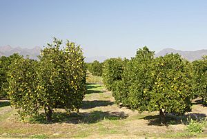
The rise in temperature could mean that growing citrus fruits outdoors might become possible. Rising sea levels could cause spring tides to go over many of the region's harbor walls. The sea level at Newlyn could increase by about 40 cm (16 inches).
After this information was released, the UK government asked local councils and other groups to get ready for these changes. All major government projects will now need to consider the risks from future climate change.
A report from the Environment Agency stated that over the next 25 years, spending on building and maintaining flood defenses would need to double. This is to keep the current levels of flood protection and deal with the effects of climate change. Currently, flooding from rivers and the sea puts 65,369 properties at risk in Devon and Cornwall. 29,577 of these are at "significant risk." Existing flood defenses protect some of these properties.
Richard Cresswell, the regional director for the Environment Agency in the South West, said:
"The latest UK climate change data shows that the risk of flooding and coastal erosion will continue to increase in future due to rising sea levels and more frequent and heavy storms."
Since 2002, £357 million (around $450 million USD) has been spent on flood risk management in Cornwall, Devon, Dorset, Somerset, South Gloucestershire, and Wiltshire. This includes spending that continued into 2009/10.
Rising sea levels are likely to cause more flooding on the Somerset Levels. Since 1990, the drainage board has been responsible for checking and clearing the rhynes (drainage ditches), with the Environment Agency overseeing the work. With rising sea levels, the cost of keeping the current sea defenses working is likely to become much higher. Some people have even suggested creating two inland seas to manage the water.
Climate charts
| Weather chart for Bude | |||||||||||||||||||||||||||||||||||||||||||||||
|---|---|---|---|---|---|---|---|---|---|---|---|---|---|---|---|---|---|---|---|---|---|---|---|---|---|---|---|---|---|---|---|---|---|---|---|---|---|---|---|---|---|---|---|---|---|---|---|
| J | F | M | A | M | J | J | A | S | O | N | D | ||||||||||||||||||||||||||||||||||||
|
98
9
4
|
76
9
3
|
69
10
4
|
55
12
5
|
52
15
8
|
57
17
10
|
55
19
13
|
71
20
13
|
81
18
11
|
98
15
9
|
105
12
6
|
106
10
5
|
||||||||||||||||||||||||||||||||||||
| temperatures in °C precipitation totals in mm |
|||||||||||||||||||||||||||||||||||||||||||||||
|
Imperial conversion
|
|||||||||||||||||||||||||||||||||||||||||||||||
| Weather chart for Nettlecombe | |||||||||||||||||||||||||||||||||||||||||||||||
|---|---|---|---|---|---|---|---|---|---|---|---|---|---|---|---|---|---|---|---|---|---|---|---|---|---|---|---|---|---|---|---|---|---|---|---|---|---|---|---|---|---|---|---|---|---|---|---|
| J | F | M | A | M | J | J | A | S | O | N | D | ||||||||||||||||||||||||||||||||||||
|
124
8
2
|
88
8
2
|
81
10
3
|
66
12
4
|
63
16
6
|
59
18
9
|
43
21
11
|
67
21
11
|
85
18
9
|
109
14
7
|
107
11
4
|
129
9
3
|
||||||||||||||||||||||||||||||||||||
| temperatures in °C precipitation totals in mm |
|||||||||||||||||||||||||||||||||||||||||||||||
|
Imperial conversion
|
|||||||||||||||||||||||||||||||||||||||||||||||
| Weather chart for Princetown | |||||||||||||||||||||||||||||||||||||||||||||||
|---|---|---|---|---|---|---|---|---|---|---|---|---|---|---|---|---|---|---|---|---|---|---|---|---|---|---|---|---|---|---|---|---|---|---|---|---|---|---|---|---|---|---|---|---|---|---|---|
| J | F | M | A | M | J | J | A | S | O | N | D | ||||||||||||||||||||||||||||||||||||
|
219
6
1
|
168
6
1
|
162
7
2
|
109
10
3
|
100
13
6
|
116
16
9
|
112
18
11
|
133
18
11
|
156
15
9
|
215
12
6
|
234
8
4
|
251
7
2
|
||||||||||||||||||||||||||||||||||||
| temperatures in °C precipitation totals in mm |
|||||||||||||||||||||||||||||||||||||||||||||||
|
Imperial conversion
|
|||||||||||||||||||||||||||||||||||||||||||||||
| Weather chart for St. Mawgan | |||||||||||||||||||||||||||||||||||||||||||||||
|---|---|---|---|---|---|---|---|---|---|---|---|---|---|---|---|---|---|---|---|---|---|---|---|---|---|---|---|---|---|---|---|---|---|---|---|---|---|---|---|---|---|---|---|---|---|---|---|
| J | F | M | A | M | J | J | A | S | O | N | D | ||||||||||||||||||||||||||||||||||||
|
120
9
4
|
87
9
4
|
81
10
5
|
62
12
6
|
59
15
8
|
65
17
11
|
56
19
13
|
73
19
13
|
90
17
11
|
108
14
9
|
121
11
6
|
121
10
5
|
||||||||||||||||||||||||||||||||||||
| temperatures in °C precipitation totals in mm |
|||||||||||||||||||||||||||||||||||||||||||||||
|
Imperial conversion
|
|||||||||||||||||||||||||||||||||||||||||||||||
| Weather chart for Teignmouth | |||||||||||||||||||||||||||||||||||||||||||||||
|---|---|---|---|---|---|---|---|---|---|---|---|---|---|---|---|---|---|---|---|---|---|---|---|---|---|---|---|---|---|---|---|---|---|---|---|---|---|---|---|---|---|---|---|---|---|---|---|
| J | F | M | A | M | J | J | A | S | O | N | D | ||||||||||||||||||||||||||||||||||||
|
102
9
4
|
83
9
4
|
68
11
5
|
55
12
6
|
52
15
9
|
51
18
11
|
36
21
14
|
57
20
13
|
67
18
11
|
83
15
9
|
84
12
8
|
113
10
5
|
||||||||||||||||||||||||||||||||||||
| temperatures in °C precipitation totals in mm |
|||||||||||||||||||||||||||||||||||||||||||||||
|
Imperial conversion
|
|||||||||||||||||||||||||||||||||||||||||||||||
| Weather chart for Yeovilton | |||||||||||||||||||||||||||||||||||||||||||||||
|---|---|---|---|---|---|---|---|---|---|---|---|---|---|---|---|---|---|---|---|---|---|---|---|---|---|---|---|---|---|---|---|---|---|---|---|---|---|---|---|---|---|---|---|---|---|---|---|
| J | F | M | A | M | J | J | A | S | O | N | D | ||||||||||||||||||||||||||||||||||||
|
72
8
1
|
56
8
1
|
57
11
3
|
47
13
4
|
49
17
7
|
57
19
10
|
49
22
12
|
57
22
12
|
65
19
10
|
68
15
7
|
66
11
4
|
83
9
2
|
||||||||||||||||||||||||||||||||||||
| temperatures in °C precipitation totals in mm |
|||||||||||||||||||||||||||||||||||||||||||||||
|
Imperial conversion
|
|||||||||||||||||||||||||||||||||||||||||||||||


