
Somerset Levels facts for kids
The Somerset Levels are a special area of wetland and flat land in Somerset, England. They stretch south from the Mendip Hills to the Blackdown Hills.
This area covers about 160,000 acres (647 square kilometers). The Polden Hills divide the Levels. Rivers like the River Parrett, Axe, and Brue help drain the land. The Somerset Levels have "levels" near the coast made of marine clay and "moors" inland made of peat. About 70% of the land is used for grassland (for animals to graze), and the rest is for growing crops. Farmers here grow willow and teazel, and some peat is also dug up.
People have lived in the Somerset Levels for a very long time. The oldest sign of humans is a flint tool found in West Sedgemoor, dating back about 500,000 years! Neolithic people used the natural resources of the reed swamps. They even built wooden paths, including the Post Track, which is the world's oldest known wooden pathway, from around 3800 BC.
The Levels were home to ancient villages built on lakes, like the Glastonbury Lake Village and two villages at Meare Lake. Settlements and hill forts were also built on natural "islands" of higher land, such as Brent Knoll and Glastonbury. During the Roman period, people extracted sea salt here. A huge collection of 9,238 silver Roman coins, called the Shapwick Hoard, was found at Shapwick. This was the second-largest Roman coin hoard ever found in Britain!
Later, in 1685, a famous battle called the Battle of Sedgemoor took place in the Bussex area of Westonzoyland.
Because the Levels are a wetland, they have amazing biodiversity, meaning a wide variety of plants and animals. It's a very important place for many plant and bird species. It's also a crucial feeding ground for birds. The area includes 32 special places called Sites of Special Scientific Interest (SSSIs), and 12 of these are also Special Protection Areas for birds.
People have been draining this land for centuries, even before the Domesday Book was written. In the Middle Ages, monasteries like Glastonbury, Athelney, and Muchelney did a lot of the drainage work. The artificial Huntspill River was built during World War II to help manage water. The Sowy River was finished in 1972. Today, local groups called internal drainage boards manage the water levels.
The Somerset Levels are considered a special "natural region" by Natural England, which looks after England's natural environment.
Contents
Geography of the Levels

The Somerset Levels are mostly flat areas of land, with some slightly higher parts called "burtles" and other hills. The land is generally about 20 feet (6 meters) above sea level. Large amounts of peat formed in the Brue Valley after the ice sheets melted long ago.
The landscape has two main basins surrounded by hills. Rivers flow from these hills across the flat land. Originally, these rivers twisted and turned, but now they are controlled by banks and sluices (called "clyses" locally). The area often floods in winter with fresh water, and sometimes with salt water from the sea. One of the worst floods happened in 1607, when the Bristol Channel floods drowned over 2,000 people and covered about 200 square miles (518 square kilometers) of farmland. Another big flood happened in 1872–1873, when over 107 square miles (277 square kilometers) were underwater for months.
Even though the lowlands were formed in the last 10,000 years, they sit on much older rock formations from the Triassic period. These older rocks stick out of the flat land, forming what used to be islands, like Athelney, Brent Knoll, Burrow Mump, and Glastonbury Tor.
The Somerset Levels are mainly used for farming. You'll see open fields of grass surrounded by ditches and willow trees. Old roads, called "droves," are often raised above the surrounding land with drainage ditches on each side.
Towns and Villages
Most settlements on the Levels are small villages. In the south, there's Aller, and the historic Isle of Athelney, where Alfred the Great once hid from the Danes. Bawdrip is another small village. Brent Knoll is a large village at the base of a 449-foot (137-meter) hill called Brent Knoll Camp, which was once an island known as the Isle of Frogs.
Glastonbury (population 8,784) and Street (11,066) are important towns that serve as central points for trade. Larger towns are usually on higher ground around the edges of the Levels. Bridgwater is a market town and a major industrial center with a population of 33,698. It was once a big port.
Along the coast, villages like Berrow are built on sand dunes that protect the low-lying marshes from the sea. Burnham-on-Sea (population 18,401) is at the mouth of the River Parrett. It has a history of building sea defenses, including a concrete sea wall finished in 1988, to protect against floods. Highbridge is another town near the mouth of the River Brue.
Weather in the Levels
The Somerset Levels have a mild and wet climate, typical of South West England. The average yearly temperature is about 10°C (50°F). Summers are warmest in July and August, with highs around 21°C (70°F). Winters are cooler, with lows around 1 or 2°C (34 or 36°F). The area gets about 700 millimeters (28 inches) of rain each year, mostly in autumn and winter. Snowfall is typical for 8–15 days a year. The strongest winds are from November to March, usually from the southwest. The Levels were heavily affected by severe storms and floods in January–February 2014.
Managing Water in the Levels

The Somerset Levels are made of a coastal clay area that's just above sea level, and an inland peat area that's even lower. This means managing water is super important!
People have tried to control water levels for a long time, possibly even since Roman times, but records only go back to the 13th century. In the Middle Ages, monasteries did a lot of the drainage work. For example, in 1234, over 700 acres (2.8 square kilometers) were reclaimed near Westonzoyland.
Drainage Channels

To stop flooding, people built embankment walls along the River Parrett. They also dug new channels for rivers. The main rivers and artificial channels that drain the Levels are the Axe, Brue, Huntspill, Parrett, Tone, Yeo, and the King's Sedgemoor Drain.
By 1500, a huge area of 70,000 acres (283 square kilometers) was prone to flooding, and only 20,000 acres (81 square kilometers) had been reclaimed. In the 17th century, there were plans to drain more land, but local people who would lose their grazing rights opposed them. Between 1785 and 1791, much of the lowest peat moors were enclosed. Farmers also started digging "rhynes" (local name for drainage channels) between their fields.
Pumping Stations

For a long time, people didn't use pumps to remove water. The first steam pumping station was Westonzoyland Pumping Station, built in 1830. Today, automatic electric pumps are used.
The man-made Huntspill River was built during World War II. It has gates at both ends to control water. It was meant to be a reservoir in summer and a drainage channel in winter. However, because it couldn't be dug deep enough, water has to be pumped into it all year round.
The Sowy River was completed in 1972. The Levels are now drained by a network of rhynes, with water pumped into larger "drains." Local drainage boards manage the water levels. The Levels are still prone to widespread fresh water flooding in winter. One way to reduce flood risk is by planting new woodlands.
Sea Defenses

The Levels used to flood often from the sea during high tides. This problem was mostly solved by improving sea defenses in the early 20th century. However, the River Parrett doesn't have a sluice gate, which means tides can still come far inland and make freshwater floods worse.
In December 1981, a big storm caused a huge sea surge in the Bristol Channel. This led to flooding over 12,500 acres (50.6 square kilometers) of land, affecting over 1,000 homes. This event led to a three-year project to repair and improve sea defenses. In Burnham-on-Sea, a large "wave return wall" was built to protect the town.
The Environment Agency is still studying how to manage floods in the Parrett area. They are considering if a tidal sluice is needed on the Parrett in the future.
Flooding in Recent Years

The Levels are at risk from both sea floods and river floods. In the past, huge floods have covered vast areas of land, sometimes poisoning it with sea water for years.
Since 1990, drainage boards have been responsible for keeping the rhynes clear. With sea levels rising, maintaining sea defenses will become more expensive. In recent years, winter flooding has cut off villages like Muchelney and Westonzoyland. In November 2012, rescue boats had to reach Muchelney to help nearly 100 people.
Even worse flooding happened in the winter of 2013–14. On January 24, 2014, local councils declared a "major incident" because 17,000 acres (69 square kilometers) of farmland had been underwater for over a month. The village of Thorney was abandoned, and Muchelney was cut off for almost a month. The Environment Minister visited the area and promised to approve a local water management plan, which would likely include dredging (clearing out) the rivers Tone and Parrett. In mid-February 2014, giant pumps from the Netherlands were brought in to help remove the water.
Human History in the Levels

The earliest sign of humans in the area is a flint tool from about 500,000 years ago. As sea levels rose, early people used the higher ground for seasonal camps. The name Somerset might even come from "Sumorsaete," meaning "land of the summer people," suggesting people only used the Levels in summer due to winter floods.
Neolithic people built wooden pathways like the Sweet Track and Post Track. The Sweet Track, discovered in 1970, is the world's oldest wooden pathway, dating back to the 3800s BC. It connected an island at Westhay to higher ground at Shapwick. Other similar tracks have been found nearby.
The Levels are home to the best-preserved prehistoric village in the UK, Glastonbury Lake Village, and two others at Meare Lake Village. These villages were built on artificial foundations of timber and other materials in marshy areas.
People continued to live here during the Bronze Age, hunting and fishing. They lived on artificial islands connected by wooden paths. Many metal objects have been found, possibly left as offerings. Brent Knoll has been settled since at least the Bronze Age and is the site of an Iron Age hill fort.
During the Roman period, sea salt was extracted, and settlements grew along the Polden Hills. The discovery of the Shapwick Hoard (9,238 silver Roman coins) shows how important the area was.
Later, Anglo-Saxon records show that the area continued to be used. Legends of King Arthur and Alfred the Great are connected to the Levels. For example, Alfred the Great is said to have burned cakes while hiding in the marshes of Athelney before a battle with the Danes.
In 1685, the Monmouth Rebellion ended with the Battle of Sedgemoor fought near Westonzoyland.
How the Land is Used
The Levels have few wooded areas, mostly just willow trees. The landscape is dominated by grassland, mainly used for dairy farming. About 70% of the land is grassland, and 30% is for crops. From January to May, young European eels, called elvers, are caught in the River Parrett using special hand nets. Eel passes have been built to help this endangered species migrate upstream.
Historically, the Levels produced cider, and many farms had their own orchards. However, over 60% of Somerset's orchards have been lost in the last 50 years. Other traditional industries like thatching (using reeds) and basket making (using willow) have also declined.
Electricity and Wind Power
In 2009, National Grid proposed building new electricity pylons to carry power from the planned Hinkley Point C nuclear power station to Avonmouth. These pylons would be 151 feet (46 meters) high, and the plans faced local opposition. The Hinkley Point C power station is a huge project to build a new nuclear power plant.
There have also been proposals to build wind turbines in the area, but local groups have opposed them due to concerns about their effect on the environment and birds.
Willow Growing

Willow has been used on the Levels since ancient times. Fragments of willow baskets were found near the Glastonbury Lake Village. Willow was harvested by "pollarding," where trees are cut back to the main stem, allowing new shoots (called "withies") to grow.
In the 1930s, over 9,000 acres (36 square kilometers) of willow were grown commercially. However, the industry declined after the 1950s due to plastic bags and cardboard boxes replacing baskets. Today, the Somerset Levels is the only area in the UK where basket willow is still grown commercially, mostly near Burrowbridge, Westonzoyland, and North Curry. Willow is used to make baskets, eel traps, lobster pots, and even frames for hot air balloon passenger baskets and coffins.
The Willow Man sculpture, 40 feet (12.2 meters) tall, celebrates this industry. It was created by artist Serena de la Hey in 2000 and can be seen from the M5 motorway. There's also a Willows and Wetlands Visitor Centre at Stoke St Gregory.
Teazel Growing
An unusual crop grown here is teazels, found near Chard. These plants are used to create a fine finish on wool fabrics and even snooker table cloths.
Peat Extraction
People have been digging up peat from the Moors since Roman times. In the 1960s, peat extraction became a big industry for gardening. However, this lowered water levels and put local ecosystems at risk. Peat extraction continues today, but much less than before.
-
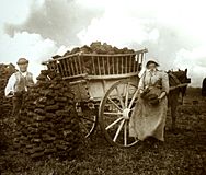
Peat gatherers, Westhay, September 1905
-
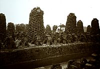
Peat stacks and cutting, Westhay, September 1905
-
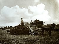
Harvesting the peat, Westhay, September 1905


Wildlife and Nature

The wetland nature of the Levels means they are incredibly rich in biodiversity. They have many plant species, including marsh marigold and meadowsweet.
The area is a vital feeding ground for many birds, such as Bewick's swan, Eurasian curlew, common redshank, and wigeon. Birds of prey like the marsh harrier and peregrine falcon also hunt here. You can find many insect species, including rare ones like the lesser silver water beetle. The Levels also support an important otter population. Efforts are being made to help water voles return to areas where they have been missing.
In 2010, a project began to reintroduce the common crane to the Levels after 400 years! Crane eggs were brought from Germany, raised at a wetland reserve, and then released onto the Levels.
The Levels contain 32 Sites of Special Scientific Interest (SSSIs), and 12 of these are also Special Protection Areas. There are also national nature reserves like the River Huntspill and Bridgwater Bay. The Somerset Levels and Moors are also a Ramsar Site, covering about 86,000 acres (348 square kilometers), which means they are wetlands of international importance.
A conservation project called the Brue Valley Living Landscape started in 2009. It aims to restore and connect habitats to help wildlife, especially with climate change. It also works to ensure farmers can still use their land profitably. About 72,000 acres (291 square kilometers) of the Levels are recognized as an Environmentally Sensitive Area.
A survey in 2005 found that many ancient wooden pathways from the Bronze Age had been destroyed because water levels dropped, exposing the wood to air and bacteria. Part of the Sweet Track is being actively preserved by keeping the water table high.
Research Projects
Somerset Levels Project
In 1964, archaeologist John Coles from the University of Cambridge started a big research project on the Levels. This led to many important papers about the area. The project explored ancient pathways from thousands of years ago and found out how important they were. One of the most significant discoveries was a Jadeite axe found during the excavation of the Sweet Track in 1970, dating back to around 3200 BC.
John Coles and the Somerset Levels Project won awards for their work, including the ICI Award in 1998 and the European Archaeological Heritage Prize in 2006.
Shapwick Project
This project, based in the village of Shapwick, was started by Mick Aston from Bristol University. It aimed to study how a typical English village developed over time. Researchers looked at old maps and documents, surveyed buildings, and excavated key sites. The project ran from 1989 to 1999, and its findings were published in eight volumes.
Visiting the Somerset Levels

Because the Levels are mostly flat, they are great for cycling! There are several cycle routes like the Withy Way Cycle Route (22 miles or 35 kilometers) and the Avalon Marshes Cycle Route (28 miles or 45 kilometers). The River Parrett Trail (47 miles or 76 kilometers) and Monarch's Way are also popular walking paths.
There are several visitor centers where you can learn about the Levels:
- The Willows and Wetlands Visitor Centre near Stoke St Gregory offers tours of willow farms and basket workshops.
- The Avalon Marshes Centre (formerly the Peat Moors Centre) between Westhay and Shapwick teaches visitors about the natural history, wildlife, and archaeology of the area. It even has reconstructions of a Roman Villa and a Saxon Longhall! You can learn about ancient highways like the Post Track and Sweet Track. The center also hosts events and courses on ancient crafts.
- The Tribunal in Glastonbury is a medieval merchant's house that displays items from the Glastonbury Lake Village, which were amazingly preserved in the peat.
- The Somerset Rural Life Museum in Glastonbury shows the history of farming and social life in Somerset. It's in buildings around a 14th-century barn that once belonged to Glastonbury Abbey. You can see old farm machinery and learn about local crafts like willow coppicing and peat digging.
- The Langport & River Parrett Visitor Centre at Langport shares details about local life, history, and wildlife.
- The Westonzoyland Pumping Station Museum, near the River Parrett, is in one of the earliest steam-powered pumping stations on the Levels, dating back to the 1830s. It has several steam engines and holds live steam days each year.
