Brent Knoll Camp facts for kids
Quick facts for kids Brent Knoll Camp |
|
|---|---|
 |
|
| Location | Brent Knoll, Somerset, England |
| Area | 1.6 hectares (16,000 m2) |
| Built | Iron Age |
| Official name: Brent Knoll hill fort | |
| Designated | 3 June 1994 |
| Reference no. | 24001 |
| Lua error in Module:Location_map at line 420: attempt to index field 'wikibase' (a nil value). | |
Brent Knoll Camp is an ancient hill fort from the Iron Age. It is located on a hill called Brent Knoll in Somerset, England. This historic site is about 3 kilometers (2 miles) from Burnham-on-Sea.
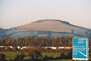
Today, Brent Knoll Camp is a protected place known as a Scheduled Ancient Monument. This means it is very important and looked after by the National Trust. The hill itself is 137 meters (449 feet) high. It stands out in the flat Somerset Levels and you can even see it from the M5 motorway.
Contents
What's in a Name? The Story of Brent Knoll
The word 'knoll' simply means a small hill or the top of a hill. The name 'Brent' has a few possible meanings. One idea is that it comes from an old English word meaning burnt. This might suggest that the settlement was once burned by the Danes.
Another idea is that 'Brent' comes from a Celtic word. This word could mean "high place," which makes sense for a hill. Or it might come from another Celtic word, briant, meaning "law." In ancient times, laws were sometimes announced from high places. It's also possible that the name 'Brent' simply comes from the local River Brent. This river also gave its name to a local area called a hundred.
Brent Knoll Hill: An Ancient Island
The hill of Brent Knoll is made up of clays and limestone. These rocks formed during the Jurassic period, which was millions of years ago. Geologically, it is like a piece of the nearby Mendip Hills that stands alone.
Long ago, before the Somerset Levels were drained, Brent Knoll was an island. It was known as the Isle (or Mount) of Frogs. It offered a safe place away from the water and marshes. The hill even became an island again for a short time during the big Bristol Channel floods of 1607. There is also a small water reservoir on the southeast side of the hill.
History of Brent Knoll Camp
Life in the Bronze and Iron Ages
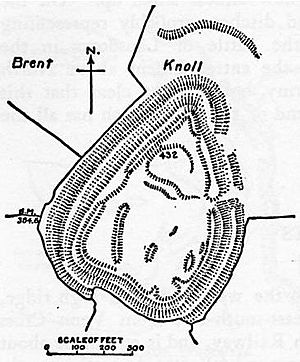
People have lived on Brent Knoll for a very long time. We know this from findings dating back to the Bronze Age. Around 2,000 BC, during the Iron Age, it became a strong hill fort. This fort covered an area of about 1.6 hectares (4 acres).
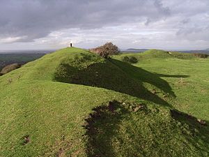
The fort was protected by a single wall, which was about 10 meters (33 feet) high. It also had a ditch around it. The main entrance was on the eastern side. There was a second bank on the northeast side for extra protection. The fort had several defensive walls, called ramparts, that followed the shape of the hill. However, these old walls have been damaged over time by farm animals and by people taking stone from the hill.
Roman Times at the Summit
The Romans also used the top of Brent Knoll as a strong point. Before the year 1790, an urn was found here. It contained coins from Roman Emperors like Trajan and Severus. Other discoveries include roof tiles and painted wall plaster. These finds suggest there was a large building, possibly a temple, rather than just a house. Many of these items can be seen in the Somerset County and Weston-super-Mare Museum. You can also find Romano-British pottery in the Blake Museum in Bridgwater.
Anglo-Saxon Battles and Legends
Brent Knoll has been suggested as the site of a famous battle called Mons Badonicus. This was a fight between Britons and an Anglo-Saxon army. It likely happened between 490 and 517 AD. Even though it was a very important event, we don't know the exact date or place for sure.
It is also believed that a battle took place here in 875 AD. In this battle, the Anglo-Saxon kingdom of Wessex fought against the Great Heathen Army. This army was led by a Viking leader named Guthrum. The Anglo-Saxons pushed them away before the Treaty of Wedmore was signed three years later.
Medieval Life and Land Use

During the medieval period, the land around Brent Knoll was owned by Glastonbury Abbey. This continued until the dissolution of the monasteries in 1536. Around the sides and top of the hill, you can see several terraces. These might be old medieval lynchets, which are banks of earth that formed from plowing fields.
Modern Discoveries and Uses
Limestone was taken from the hill, possibly in the 1800s. However, the exact date is not known. During World War II, Brent Knoll was used as a gun position. It was manned by the Home Guard. You can still see the remains of trenches on the western and southwestern sides.
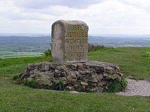
In 1979, the National Trust bought about 13.285 hectares (32.83 acres) of the land. A stone marker on the hill also acts as a triangulation station. This marker celebrates the golden jubilee of Queen Victoria. In 2006, a special survey was done at the north end of the hill fort. It showed some straight lines underground, which might be the remains of old buildings.
Legend of the Mount of Frogs
According to an old story, Ider, the son of Nuth, was one of King Arthur's knights. He came to the Mount of Frogs, which is another name for Brent Knoll. His mission was to defeat three giants who lived there.
 | Claudette Colvin |
 | Myrlie Evers-Williams |
 | Alberta Odell Jones |


