River Axe (Bristol Channel) facts for kids
Quick facts for kids River Axe |
|
|---|---|

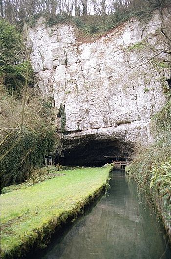
The Axe emerging from the limestone at Wookey Hole Caves
|
|
| Country | England |
| County | Somerset |
| District | Somerset Levels |
| Cities | Wookey, Henton |
| Physical characteristics | |
| Main source | Mendip Hills Wookey Hole Caves, Mendip, Somerset, England 51°13′41″N 2°40′17″W / 51.22806°N 2.67139°W |
| River mouth | Weston Bay Brean Down, Sedgemoor, Somerset, England 51°19′15″N 2°59′34″W / 51.32083°N 2.99278°W |
| Basin features | |
| Tributaries |
|
The River Axe is a river found in the South West England region. This river starts from water that flows into underground holes, called swallets, in the limestone rock. It then comes out of the ground at Wookey Hole Caves in the Mendip Hills in Somerset.
The river flows through a V-shaped valley. The rock in this area is mostly limestone. The water reaches Wookey Hole through many underground tunnels. These tunnels have been carved out by the water dissolving the limestone over time. The River Axe eventually flows into Weston Bay, which is part of the Bristol Channel.
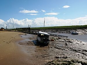
For many centuries, from the Middle Ages until 1915, boats could travel on the river. In its early days, it was even used for trade with other European countries.
Where the River Axe Flows

The River Axe begins when water enters the cave systems. It flows through the first and third chambers of the caves. From there, it goes through two underwater tunnels, called sumps, which are about 40 meters and 30 meters long. After these tunnels, the river comes out into the open air.
This is the second largest "resurgence" (where an underground river comes to the surface) in the Mendip Hills. The area that collects water for the river, called its catchment area, is about 46.2 square kilometers. On average, the river flows out at 789 liters per second.
Some of the water comes from outside the limestone areas. This water collects in streams on the surface. It then sinks into the ground through swallets near the edge of the limestone. One example is Plantation Swallet, near Priddy. This water then travels through large cave systems like Swildon's Hole and Eastwater Cavern. However, most of the river's water (about 95%) soaks directly into the limestone.
From the village of Wookey Hole, the river flows through a narrow valley, called a ravine. It then goes west through the village of Wookey. Here, the river splits into two parts. The 'Lower River Axe' flows more to the south, towards Henton. It then joins other small waterways and drains that supply water to local wetlands.
The main River Axe continues west through Knowle Moor. The two parts of the river eventually meet up again where Knowle and Panborough Moors join.
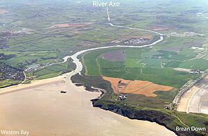
The river then continues northwest past Wedmore Moor and through areas like Oxmoor, Stoke Moor, and Monk Moor. It passes through Lower Weare and south of Loxton. From this point, until it flows between Uphill Cliff and Brean Down and reaches Weston Bay, the river forms the border between Sedgemoor and North Somerset.
The River Axe has several smaller rivers that flow into it. These are called tributaries. They include the Cheddar Yeo, the Mark Yeo, and the Lox Yeo River.
History of the River Axe
The name "Axe" comes from an old British word. This word means "full of fish." You can find this same root in the names of other rivers like the River Axe in Lyme Bay, the River Exe, and the River Usk. It's similar to the Welsh word for fish, pysgod.
The lower parts of the River Axe were historically used for boats. Ships could travel from the harbor at Uphill all the way to Weare. Today, the tide only reaches as far as the sluice gates at Bleadon and Brean Cross.
In the Middle Ages, there was a busy port at Rackley. This port was used for trade with other countries. Rackley is now a farm, but it used to be on the river. In the 1300s, a French ship sailed up the river to Rackley. A man named Thomas Tanner from Wells used Rackley to send cloth and corn to Portugal. In return, he received iron and salt.
Later, slate was brought in through this route. It might have been possible to trade through Rackley until 1915. That year, a law was passed to drain the Axe and install a flood gate at Bleadon. Bleadon was also a small port for many years. When the railway arrived in 1841, Bleadon became the furthest point boats could reach. The last time a ship used Bleadon was in 1942.
The river also powered 11 watermills in the past. Today, only one of these mills remains, located at Burcott.
 | Valerie Thomas |
 | Frederick McKinley Jones |
 | George Edward Alcorn Jr. |
 | Thomas Mensah |


