
River Huntspill facts for kids
Quick facts for kids River Huntspill |
|
|---|---|

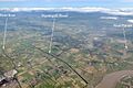
The Huntspill river crossed by a railway bridge and the M5 motorway
|
|
| Country | England |
| County | Somerset |
| Region | Somerset Levels |
| District | Sedgemoor |
| City | Street |
| Physical characteristics | |
| River mouth | River Parrett Huntspill, Somerset, England 0 ft (0 m) 51°12′29″N 3°00′52″W / 51.20806°N 3.01444°W |
| Length | 5 mi (8.0 km) |
The River Huntspill is a special river in Somerset, England. It's not a natural river; people built it! It was created in 1940 to help a factory called ROF Bridgwater get water. Building this river also helped stop floods in the nearby Brue Valley. At its western end, a structure called Huntspill Sluice keeps it separate from the River Parrett.
A big part of the river and the land around it is a special protected area. It's called a national nature reserve. The Environment Agency helps look after this important place.
Contents
History of the Huntspill River
Why the River Huntspill Was Built
The idea for the Huntspill River first came up in 1853. A person named J. Aubrey Clark thought it would be a good way to improve drainage. This would help water flow away better from the lower River Brue area. Even though he really pushed for the plan, nothing happened for a long time. It was hard to get different groups to agree on who should pay for it.
Building for Wartime Needs
When World War II started, a new factory was planned. This factory, ROF Bridgwater, would make explosives. It needed a huge amount of water every day. Louis Kelting, an engineer, brought back the old plans for the Huntspill River. He saw a way to solve the factory's water problem and improve drainage at the same time. The project would supply water to the factory. It would also drain a large area of land, including places that often flooded.
How the River Was Constructed
Work on the river started quickly in January 1940. It was a very important project for the war effort. A straight channel, about 5 miles (8 km) long, was dug. Workers used a special machine called a dragline excavator to dig the earth. The river runs from a place called Gold Corner to the River Parrett. It has special gates, called sluices, at both ends. This means it can act like a long water storage area. In summer, it could hold water. In winter, it would help drain water away.
Overcoming Building Challenges
The original plan was for a deeper channel. However, the ground underneath was made of peat, which is a soft, spongy soil. The heavy banks built along the river caused the peat to push up into the channel. Engineers had to experiment to find the best size for the river. They found that a shallower channel, about 16 feet (5 meters) deep, worked best. The banks also had to be built further back from the river's edge. Because the river was not as deep, water from the South Drain had to be pumped into it. The pumping station at Gold Corner had to be made bigger to handle all the water.
Helping the River Brue
Once the South Drain's water flowed into the Huntspill River, an older section of the drain became less important. Instead of letting it fill up, it was made wider. A new sluice, called Cripps sluice, was built where it met the River Brue. This allowed floodwater from the Brue to be sent south to the Huntspill River. This greatly reduced flooding in the Brue valley. The pumping station has been updated over the years.
Ancient Discoveries and Costs
As the channel was dug, workers found remains of Roman salt works. These ancient sites can still be seen near the river. Building bridges over the river was also tricky. Long poles, called piles, had to be driven deep into the ground to support them. The first pumps started working in 1942. The whole project cost a lot of money, about £411,594 at the time. This included building the new pumping station and buying its machinery.
Wildlife and Nature along the River Huntspill
A large part of the Huntspill River is a special place for nature. This 366-acre (148-hectare) area is a national nature reserve. It stretches from Gold Corner to Huntspill Sluice. The Environment Agency manages this reserve. This is a bit different because most nature reserves in England are managed by Natural England. However, Natural England still helps pay for the river's upkeep as a reserve.
Important Nature Sites
The river and its surrounding area include several Sites of Special Scientific Interest (SSSIs). These are places with special plants, animals, or geology.
- Street Heath, Shapwick Heath, and Westhay Heath are affected by the water levels in the South Drain.
- The water levels in Catcott, Edington and Chilton Moors SSSI are directly controlled by the Gold Corner pumping station. This site is important for its wet grasslands and the many types of flowers found there. It also has lots of wildlife in its ditches. Many wading birds, like lapwings, redshanks, and snipes, live here.
The Huntspill River flows into the River Parrett. The Parrett then flows into Bridgwater Bay, which is another important national nature reserve. This bay is on the edge of the Bristol Channel.
Water Quality of the Huntspill River
The Environment Agency checks the water quality of rivers in England. They give each river an overall "ecological status." This status can be high, good, moderate, poor, or bad. They look at different things to decide this.
How Water Quality is Measured
- Biological status: This looks at the types and numbers of tiny creatures (like invertebrates), plants (like angiosperms), and fish in the water.
- Chemical status: This checks the levels of different chemicals in the water. They compare these levels to safe amounts. Chemical status is either "good" or "fail."
In 2016, the water quality of the Huntspill River was measured as follows:
| Section | Ecological status | Chemical status | Overall status | Length | Catchment | Channel |
|---|---|---|---|---|---|---|
| Huntspill | Moderate | Good | Moderate | 4.9 miles (7.9 km) | 11.73 square miles (30.4 km2) | artificial |
Points of Interest along the River
| Point | Coordinates (Links to map resources) |
OS Grid Ref | Notes |
|---|---|---|---|
| Huntspill sluice | 51°12′23″N 3°00′50″W / 51.2064°N 3.0138°W | ST292457 | River Parrett |
| A38 Bleak Bridge | 51°11′54″N 2°59′34″W / 51.1982°N 2.9928°W | ST307448 | |
| M5 motorway bridge | 51°11′39″N 2°58′15″W / 51.1941°N 2.9709°W | ST322443 | |
| Intake to ROF Bridgwater | 51°11′25″N 2°56′59″W / 51.1903°N 2.9498°W | ST337438 | |
| Gold Corner entry sluice | 51°11′00″N 2°54′25″W / 51.1832°N 2.9069°W | ST367430 | Cripps River and South Drain |
Images for kids
-
A view of the Huntspill River.

