
Blackdown Hills facts for kids
Quick facts for kids Blackdown Hills |
|
|---|---|

Blackdown Hills AONB near Dalwood, Devon
|
|

Location of the Blackdown Hills AONB in the UK
|
|
| Location | Devon Somerset, England |
| Area | 370 km2 (140 sq mi) |
| Established | 1991 |
| Governing body | Blackdown Hills AONB |
The Blackdown Hills are a beautiful range of hills located on the border between Somerset and Devon in south-west England. In 1991, this special area was named an Area of Outstanding Natural Beauty (AONB). This means its unique landscape is protected and cared for.
The hills are like a flat tabletop, made mostly of hard chert rock and some leftover chalk. Rivers have cut valleys through this high land. The Blackdown Hills are home to many different plants and animals. Because of this, 16 areas here are called Sites of Special Scientific Interest (SSSIs). This helps protect their amazing wildlife.
People have lived in the Blackdown Hills for a very long time, since the Iron Age. You can find old hill forts from ancient times. There are also Norman motte-and-bailey castles and even old Second World War airfields. The area also has historic churches. Many small roads cross the hills, and big roads like the M5 motorway run nearby.
Contents
What is a Natural Region?
The Blackdown Hills are considered a "natural region." This means they have their own special landscape and features. Natural England, a group that looks after England's natural places, has given it the number 147.
The Blackdown Hills are surrounded by other natural regions. To the west are the Devon Redlands. To the north, you'll find the Vale of Taunton and Quantock Fringes. The Mid Somerset Hills are to the northeast, and the Yeovil Scarplands are to the east. Finally, the Marshwood and Powerstock Vales are to the southeast.
Geography of the Blackdown Hills
The Blackdown Hills Area of Outstanding Natural Beauty (AONB) covers about 370 square kilometres (140 square miles). It stretches across the border of Somerset and Devon. The highest point is Staple Hill in Somerset, which is 315 metres (1,033 feet) above sea level. The hills in the southern part, near Honiton in Devon, are not as steep.
The Blackdown Hills don't have many people living there. A lot of the land is used for dairy farming, where cows are raised for milk.

Several rivers start in the Blackdown Hills. The River Culm begins near Culmhead. It flows west through places like Hemyock and Culmstock. It then joins the River Exe near Exeter. The name "Culm" might mean "knot" or "tie" because of the river's twists. It could also come from an old Celtic word meaning "winding stream."
The River Otter starts near Otterford. It flows south for about 32 kilometres (20 miles). It reaches the English Channel at Lyme Bay. The rocks under the Otter Valley hold a lot of groundwater. This water is used for drinking in places like Taunton. Other rivers in the area include the River Yarty and the Corry Brook.
Many villages are found in the Blackdown Hills. In the northern, Somerset part, you'll find Staple Fitzpaine, Buckland St Mary, Whitestaunton, Wambrook, and Churchstanton. The larger southern area in Devon includes Dunkeswell, Luppitt, Upottery, Smeatharpe, Hemyock, Blackborough, Yarcombe, Membury, Stockland, Sheldon, Cotleigh, and Chardstock.
Geology: What the Hills are Made Of
The Blackdown Hills have a special geology in south-west England. They are one of the few places where you can see a lot of Upper Greensand rock.
The hills are like a flat plateau. They are mostly made of hard chert bands, which are a type of clay with flints. These rocks are part of the Upper Greensand layer. Some leftover chalk can also be found. These Cretaceous rocks sit on top of older Jurassic and Triassic rock layers. In the western parts, the Upper Greensand doesn't have much chalk. But it does contain fossils of sea creatures like clams and snails, preserved in silica.
Many of the steep slopes in the Blackdowns have been affected by landslides. This is especially true on the long northern edge of the hills. These areas often have patches of "head," which are local clays, sands, and gravels.
Climate in the Blackdown Hills
The Blackdown Hills have a temperate climate, just like the rest of south-west England. This means it's generally wetter and milder than other parts of England.
The average temperature is about 10°C (50°F). Temperatures change with the seasons and throughout the day. But because the sea is nearby, the temperature doesn't change as much as in other parts of the United Kingdom. January is the coldest month, with low temperatures between 1°C (34°F) and 2°C (36°F). July and August are the warmest months, with high temperatures around 21°C (70°F).
December is usually the cloudiest month, and June is the sunniest. When there's high pressure over the Azores, it often brings clear skies to south-west England, especially in summer.
The area gets about 1,600 hours of sunshine each year. Rain usually comes from Atlantic storms or from warm air rising. In summer, the sun heating the ground can cause shower clouds and thunderstorms. A lot of the rain at this time of year comes from these showers. The average rainfall is about 900–1500 mm (35–60 inches). It typically snows for about 10–20 days a year.
Winds are strongest from November to March and lightest from June to August. The wind usually blows from the south-west.
| Climate data for Dunkeswell 252m, 1981–2010 | |||||||||||||
|---|---|---|---|---|---|---|---|---|---|---|---|---|---|
| Month | Jan | Feb | Mar | Apr | May | Jun | Jul | Aug | Sep | Oct | Nov | Dec | Year |
| Mean daily maximum °C (°F) | 6.7 (44.1) |
6.7 (44.1) |
9.0 (48.2) |
11.4 (52.5) |
14.7 (58.5) |
17.4 (63.3) |
19.4 (66.9) |
19.1 (66.4) |
16.7 (62.1) |
12.9 (55.2) |
9.5 (49.1) |
6.9 (44.4) |
12.6 (54.7) |
| Mean daily minimum °C (°F) | 1.7 (35.1) |
1.4 (34.5) |
2.8 (37.0) |
3.8 (38.8) |
6.8 (44.2) |
9.5 (49.1) |
11.7 (53.1) |
11.7 (53.1) |
9.8 (49.6) |
7.4 (45.3) |
4.5 (40.1) |
2.3 (36.1) |
6.1 (43.0) |
| Average precipitation mm (inches) | 112.5 (4.43) |
82.7 (3.26) |
79.9 (3.15) |
75.0 (2.95) |
72.3 (2.85) |
66.0 (2.60) |
66.8 (2.63) |
73.8 (2.91) |
81.6 (3.21) |
117.6 (4.63) |
115.9 (4.56) |
121.2 (4.77) |
1,065.3 (41.94) |
| Mean monthly sunshine hours | 55.0 | 75.1 | 109.0 | 166.5 | 191.0 | 204.6 | 196.8 | 188.9 | 146.5 | 101.8 | 71.0 | 55.4 | 1,561.6 |
Ecology: Amazing Wildlife
There are 16 Sites of Special Scientific Interest (SSSIs) in the Blackdown Hills. These are special places protected by Natural England because they have important plants, animals, or geological features. They cover about 640 hectares (1,580 acres), which is nearly 2% of the AONB. Most of these SSSIs are well-managed to protect their natural beauty.
The grasslands, heathland, meadows, and wet areas are home to many birds. You might see barn owls and nightjars. Many butterflies also live here, like the marbled white, green hairstreak, and gatekeeper butterfly.
The plants include the heath spotted-orchid, corky fruited water dropwort, green-winged orchid, heather, lousewort, and birds foot trefoil. The hedgerows and woodlands have trees like ash, hazel, grey willow, and pedunculate oak. These trees provide homes for dormouses, common lizards, siskins, and the purple hairstreak butterfly. The rivers and streams are where you can find kingfishers, otters, and Daubenton's bats.
Blackdown and Sampford Commons are great examples of heathland, woodland, and marshy grasslands. These habitats have grown on the acidic soils of the Blackdown Hills. The heathland has many insects, including a wide variety of butterflies and lots of spiders. This area is also very important for birds that like heathland.
Quants is a grassy area in a forest plantation. It's famous for its butterflies, such as the Duke of Burgundy, marsh fritillary, and wood white. It's being considered as a Special Area of Conservation (cSAC). These are special places recognized by the European Union as important habitats for wildlife.
History of the Blackdown Hills
People have lived in the Blackdown Hills since ancient times. Studies show that open meadows and grasslands with some small woods existed here during the Mesolithic and Neolithic periods. There are also several Bronze Age burial sites, like Robin Hood's Butts near Otterford.
Ancient Hill Forts
Important archaeological sites include Iron Age hill forts at Membury Castle, Hembury, and Castle Neroche. Hembury is an ancient Neolithic enclosure near Honiton. It dates back to about 4,000 to 5,000 BC. It might have been the main settlement for the Dumnonii tribe. The fort is on a high point overlooking the River Otter, Devon. Later, an Iron Age hill fort was built on the same spot.
Archaeologists have also found evidence of Roman soldiers living here. This suggests a Roman fort was built inside the existing Iron Age site. Today, Hembury is a Scheduled Ancient Monument, which means it's protected.
Fourteen hill slope enclosures from the Iron Age have been found in the Blackdown Hills. Prehistoric remains, from around 100 BC, have also been discovered in Hemyock.

Norman Castles
Castle Neroche is a Norman motte-and-bailey castle near Staple Fitzpaine. It was built on the site of an even older hill fort. The hill rises to 260 metres (850 feet) on the northern edge of the Blackdown Hills. The castle was likely built by Robert of Mortain in the 11th century. It probably stopped being used in the 12th century.
Around Staple Fitzpaine, you can see large sandstone boulders called "devilstones." Legend says the Devil threw them from Castle Neroche! People also say if you prick them with a pin, they will bleed. The village name "Staple" might come from an old English word for pillar or post. The "Fitzpaine" part comes from the Fitzpaine family, who owned the land from 1233 to 1393.
In Whitestaunton, a Roman bath house and an Edwardian folly (a decorative building) were dug up by the TV show Time Team. There's also proof of iron mining during the Roman-British period at Dunkeswell. This suggests the hills might have looked quite industrial back then, which could be why they're called the "Blackdown Hills." Local iron was melted in small furnaces in Hemyock until the Middle Ages.
Beacons and Later History
Just north of Culmstock, you'll find Culmstock Beacon. This is one of a chain of Elizabethan beacons built in 1588. These beacons were lit to warn people if the Spanish Armada was sighted. This is the only stone beacon structure left from that time.
Hemyock manor house was allowed to be fortified in 1380 by King Richard II. This meant they could build walls and towers to protect it. Over the years, Hemyock Castle had many famous owners. During the English Civil War, it was held by Parliament. It was attacked and then partly destroyed so it couldn't be used as a fort anymore. Parts of the castle walls, towers, and moat still remain today. It's a scheduled ancient monument and has displays about its history.

Coldharbour Mill was built around 1800. It used the power of the River Culm to make wool and yarn. It stopped being a factory in 1981. Now, it's a museum that teaches people about the area's industrial past.
The Wellington Monument is on Wellington Hill, about 3 kilometres (2 miles) south of Wellington. It was built to celebrate the Duke of Wellington's victory at the Battle of Waterloo. Building started in 1817, but it wasn't finished until 1854. It looks like an Egyptian obelisk but shaped like a bayonet from Wellington's army. The National Trust now owns it, and it's lit up at night.

The artist Robert Polhill Bevan painted in the Blackdown Hills from 1912 to 1925. He was a guest of Harold Harrison, a landowner and artist. Bevan continued to paint the Bolham valley and nearby Luppitt for the rest of his life. His unique style fit well with the strong patterns of the landscape. Many of his paintings from this area are now in national museums.
World War II Airfields
During the Second World War, airbases were built at Dunkeswell, Upottery, and Culmhead. Dunkeswell Aerodrome was built by the RAF. It was briefly used by the USAF and then by the USN. It was the only American Navy air base built on UK soil during the Second World War.
A local legend says that the Holman Clavel Inn is home to a hearth spirit named Chimbley Charlie.
Government and Protection
Since 1991, the Blackdown Hills have been an Area of Outstanding Natural Beauty (AONB). AONBs are similar to national parks in England and Wales because they have the same high-quality landscapes. Both are created under the National Parks and Access to the Countryside Act 1949.
However, national parks have their own special groups that can stop building projects that don't fit the area. AONBs have fewer strict rules for local councils. More protection for AONBs was added by the Countryside and Rights of Way Act 2000.
In 2001, about 13,300 people lived in the Blackdown Hills AONB. Most of them (10,500) live in Devon, and 2,800 live in Somerset. Many villages have their own parish councils that help with local issues.
The Blackdown Hills AONB is managed by a group of public bodies, local groups, and volunteers. Funding comes from the Devon and Somerset County Councils, and other local councils like East Devon and South Somerset. Natural England also provides funding.
The AONB is located across three areas represented in the UK Parliament: Tiverton and Honiton, Taunton Deane, and Yeovil.
Religious Sites

Dunkeswell Abbey was a Cistercian monastery founded in 1201. It was closed in 1539, and most of it was torn down. A small part was used as a house until the 1800s. In 1842, a church was built on part of the site. Some old carved pieces from the monastery can still be seen in the Victorian era church.
The Church of St Peter in Staple Fitzpaine was first built in the Norman style. It still has a Norman doorway. The main part of the church is from the 14th century. The north side was added, and new windows were put in during the 15th century. The tower is from about 1500. The porch and vestry are much newer, from 1841. The tower has a special top with crenellated walls. English Heritage has given the church a Grade I listed building status, meaning it's very important historically.
Transport in the Hills
The Blackdown Hills have many small roads. There are also several major roads nearby, including the A30, A303, and A35. The M5 motorway is on the north-western edge of the AONB.
The Bristol to Exeter line (a railway) and the remains of the Grand Western Canal run close to the M5 motorway. They don't go through the Blackdown Hills themselves. The West of England Main Line railway passes through the southern part of the hills, between Axminster and Honiton. It even goes through a tunnel east of Honiton.
The Culm Valley Light Railway opened in 1876. It was bought by the Great Western Railway in 1880. The line stopped carrying passengers in 1963. It continued to serve a milk depot in Hemyock until 1975.
Dunkeswell Aerodrome is now a busy civilian airfield. It's used by light aircraft, microlights, and for parachuting.
Economy: How People Make a Living
The Blackdown Hills AONB is special because it doesn't have any large towns or cities within its borders. Most jobs are in the towns around the hills. There are also some small industrial parks, especially near Dunkeswell airfield.
Recently, there's been a growing interest in local and sustainable food. This has led to many new small food and drink businesses in the area. Tourism also helps the local economy. Visitors come to the Blackdown Hills for activities like walking and riding.
The Blackdown Hills Business Association was started in 2002. It helps and supports businesses in or serving the Blackdown Hills. It has about 400 member businesses.
Images for kids
-
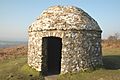
Stone structure built in 1588 to support a wooden pole and fire basket(s). Fire(s) would be lit as a signal that the Spanish Armada had been sighted. Of the chain of beacon sites across Southern England, this is the only remaining stone structure.
