
Burrow Mump facts for kids

Burrow Mump is a special hill and historic site in the village of Burrowbridge, Somerset, England. It looks out over Southlake Moor. The hill is a protected historic site called a 'scheduled monument'. The old church on top is also a 'Grade II listed building', which means it's an important historic structure.
This hill is in a key spot where three rivers meet: the River Tone, the old River Cary, and the River Parrett. People think Romans might have visited here long ago. The first fort built on the hill was a Norman 'motte' (a type of castle mound). Some people call it King Alfred's Fort, but there's no real proof that Alfred the Great used it. A medieval church was built here in the 1400s. The church you see in ruins today was built in 1793. In 1946, the land and ruins were given to the National Trust as a memorial for soldiers who died in wars.
Contents
What is Burrow Mump?

Burrow Mump is also known as St Michael's Borough or Tutteyate. Both 'burrow' and 'mump' mean 'hill'. The hill is about 24 meters (79 feet) high. It stands out because it's surrounded by the low-lying Somerset Levels.
The hill is made of Triassic sandstone. This rock is topped with a type of clay called Keuper marl.
Early History of the Hill
Archaeologists have found some Roman items here, like pottery and coins. This suggests the hill might have been used for trade because it's near where rivers meet.
During excavations, square pits and post holes from the Middle Ages were found. One pit might have been a well. These findings could be from an 'adulterine castle'. This was a castle built without the king's permission.
It's likely that Burrow Mump was a Norman 'motte'. This type of castle had a mound (motte) and a walled area (bailey). A path spirals around the hill to reach the top. The flat area at the top is about 45 meters (148 feet) by 25 meters (82 feet). This area, along with the steep top of the slope, formed the motte. It might have been built during a time of conflict called The Anarchy (1135-1153).
Even though it's called King Alfred's Fort, there's no proof it was a fort used by Alfred the Great. However, the nearby Athelney Abbey, which Alfred founded, owned Burrow Mump. A causeway (a raised road) linked the two sites. The hill might have been a natural defense for Athelney at the end of the 800s.
Excavations also show there was a stone building on the hill in the 1100s. This might have been part of the unauthorized castle. The sides of the hill might have been terraced for farming. This was because the land around it often flooded in medieval times.
The Medieval Church

The first written record of Burrow Mump is from around 1480. William Worcester called it Myghell-borough. A medieval church dedicated to St Michael was on the hill. It belonged to Athelney Abbey and dates back to at least the mid-1400s.
This church was used as a safe place for royalist soldiers during the English Civil War in 1642 and 1645. A part of the king's army also used it in 1685 during the Monmouth Rebellion.
Rebuilding in the 1700s
In 1793, people tried to rebuild the church. They planned a new tower, a main hall (nave), and a south porch. They used local stone called lias with red brick and Hamstone. However, they couldn't raise enough money to finish the whole church. Even with donations from important people like William Pitt the Younger and Admiral Hood, they couldn't complete it.
Instead, a new church for the community was built at the bottom of the hill in Burrowbridge in 1838. In the mid-1900s, some repairs were made to the ruined church on Burrow Mump.
The ruined church is one of several churches dedicated to St. Michael that are said to be on a 'ley line'. This idea was suggested by writer John Michell. Other St. Michael's churches on this line include those at Othery and Glastonbury Tor.
A War Memorial
.jpg)
In 1946, Major Alexander Gould Barrett gave the hill and the ruined church to the National Trust. The site is about 3.573 hectares (8.83 acres). It serves as a memorial to the 11,281 men from Somerset who died in the First and Second World Wars.
The ruined church was officially listed as a Grade II listed building in 1963. The hill itself has been a 'Scheduled monument' since 1949, protecting its historical importance.
Images for kids
-
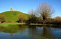
Burrow Mump and St Michael's Church
-
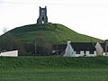
Burrow Mump from the village of Burrowbridge
-
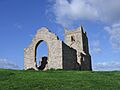
The ruins of St Michael's Church on top of Burrow Mump
-
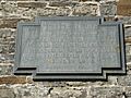
Memorial plaque
