Chard, Somerset facts for kids
Quick facts for kids Chard |
|
|---|---|
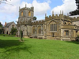 Church of St. Mary the Virgin |
|
| Population | 14,287 (2021) |
| OS grid reference | ST325086 |
| Civil parish |
|
| District | |
| Shire county | |
| Region | |
| Country | England |
| Sovereign state | United Kingdom |
| Post town | CHARD |
| Postcode district | TA20 |
| Dialling code | 01460 |
| Police | Avon and Somerset |
| Fire | Devon and Somerset |
| Ambulance | South Western |
| EU Parliament | South West England |
| UK Parliament |
|
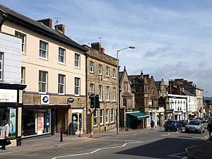
Chard is a town in Somerset, England. It is located near the borders of Devon and Dorset. Chard is about 15 miles (24 km) southwest of Yeovil. Around 14,000 people live in the town. At 121 meters (397 ft) high, Chard is one of the highest and southernmost towns in Somerset. It is part of the South Somerset area.
The town's name was Cerden in 1065. It was called Cerdre in the Domesday Book of 1086. After the Norman Conquest, the Bishop of Wells controlled Chard. King John gave Chard its first special document (charter) in 1234. A big fire destroyed most of the town in 1577. It was also damaged during the English Civil War.
In 1685, during the Monmouth Rebellion, the Duke of Monmouth was declared King in Chard. This happened before he was defeated at the Battle of Sedgemoor. Later, 12 rebels were punished near where the Tesco roundabout is today. The Chard Canal was built between 1835 and 1842. A railway line, the Chard Branch Line, connected Chard to main lines from 1860 until 1965.
Chard has a very unusual feature: two streams run along either side of Fore Street. One stream flows into the Bristol Channel. The other stream reaches the English Channel. Chard Reservoir, northeast of town, is a special nature area. Snowdon Hill Quarry is a geological site. Major employers in Chard include Numatic International Limited. The town has sports, culture, and schools like Holyrood Academy. The Church of St Mary the Virgin dates back to the late 11th century.
Contents
Chard's History
The oldest signs of people living near Chard are from the Iron Age. This was an ancient fort called Cotley Castle. There was a small Saxon village around the church, still known as 'Old Town'. Chard's name means "house on the rough ground" in Old English.
Before the Normans arrived, the Bishop of Wells owned Chard. King John gave the town its first official document in 1234. This document set the town's boundaries. It also allowed people to rent land for a small yearly fee.
A large fire destroyed most of Chard in 1577. After the fire, many buildings were rebuilt. These included Waterloo House and Manor Court House. They are now shops and offices. The town was also damaged during the English Civil War. Both sides took supplies from Chard, especially in 1644.
In 1663, Richard Harvey left money in his will to build special homes for the poor, called Almshouses. These became Harvey's Hospital. They were rebuilt in 1870. In 1685, during the Monmouth Rebellion, the Duke of Monmouth was declared King in Chard. Many local people joined his army. After the rebellion failed, 12 rebels were punished near the town.
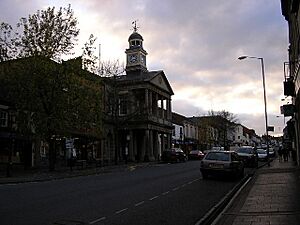
By 1394, Chard had a mill for making cloth. After 1820, the textile industry grew. Chard became a center for making lace. Many lace makers moved here from the English Midlands. The Guildhall was built in 1834. It was first used for trading corn and as a town hall.
On Snowdon Hill, there is a small cottage. It was a toll house built in the 1830s. People paid a fee there to use a road that avoided a steep hill.
Chard is famous as the birthplace of powered flight. In 1848, John Stringfellow (1799–1883) showed that engine-powered flight was possible. He worked on his "Aerial Steam Carriage" here. Another inventor from Chard, James Gillingham (1839–1924), created early artificial limbs. He made one for a man who lost his arm in 1863. The Chard Museum has a display of Gillingham's work.
Chard was an important part of the Taunton Stop Line during World War II. This was a defensive line with small forts (pillboxes) and anti-tank barriers. In 1938, a bomb-proof bunker was built behind the Westminster Bank. It stored copies of bank records. It also held emergency bank notes for the Bank of England. Some people think the Crown Jewels were stored there too, but this is not confirmed.
Action Aid, a charity that helps people around the world, started in Chard in 1972. Their Supporters Services department is still based in Chard.
Local Government
Chard has a town council. This council handles local issues for the town. It looks at plans for new buildings. It also works with the police and local groups on crime and traffic. The council helps maintain local facilities. It also talks with the district council about roads, drainage, and street cleaning. Environmental issues and historic buildings are also the council's responsibility. The council sets a local tax to cover its costs. Its offices are in the Guildhall, a historic building.
The South Somerset district council manages other services. These include local planning, building rules, and council housing. They also handle environmental health, markets, and trash collection. Parks and tourism are also their responsibility.
Somerset County Council runs larger services. These include education, social services, and libraries. They also manage roads, public transport, and waste disposal. Fire, police, and ambulance services are shared with other areas.
Chard is part of the Yeovil area for the UK Parliament. It elects one Member of Parliament (MP).
Sister Cities
Chard has special connections with towns in other countries. These are called "sister cities" or "twinnings."
- Helmstedt in Germany (since 1980)
- Morangis, Essonne in France (since 1994)
- Șeica Mare in Transylvania, Romania
Geography and Nature
Chard is 121 meters (397 ft) above sea level. This makes it one of the highest towns in Somerset. It is also the southernmost town in the county. Some of its areas include Crimchard, Furnham, and Old Town. As mentioned, two streams run along Fore Street. One stream flows to the Bristol Channel. The other stream flows to the English Channel.
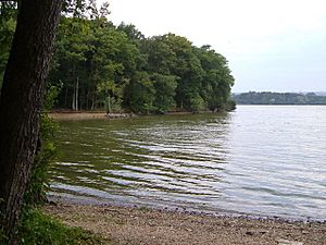
Chard Reservoir is about a mile (1.6 km) northeast of the town. It covers 36.97 hectares (91.4 acres). This area is a Local Nature Reserve. People use it for walking, fishing, and watching birds. You can often see grey herons, kingfishers, and ducks there. Sometimes, rarer birds like the great white egret are seen.
Snowdon Hill Quarry is a special geological site. It is 0.6 hectares (1.3 acres) in size. The site shows rocks from the Upper Greensand and Chalk periods. These rocks contain very old and well-preserved fossils of sea creatures. This makes it an important place for studying palaeontology in Britain.
Chard also has caves. They were first mentioned in 1235. They were used by stonemasons to get building stone. The cave is smaller now, but a part of it still exists 20 feet (6.1 m) underground.
Economy and Industry
Making textiles was important for Chard during the Middle Ages. Chard is known as the place where powered flight began. In 1848, John Stringfellow showed that engine-powered flight was possible. Percy and Ernest Petter, who started Westland Aircraft Works, saw Stringfellow's work. They later asked for his help when setting up their first aircraft factory.
Chard is home to Numatic International Limited. This company makes the famous 'Henry' vacuum cleaners. These vacuums have a big smiling face. The company employs over 700 people. Unlike some other companies, Numatic still makes its products in Britain. Their factory covers more than 10 hectares (25 acres). They produce over 4,000 products every day.
Oscar Mayer was another large employer in Chard. They made packaged ready-meals for different brands. In 2020, Oscar Mayer decided to close its Chard factories. Most of the staff lost their jobs. The company moved its business to other UK sites by late 2021.
Chard is also home to Brecknell Willis. This company is one of the oldest in the world. They design and install railway electrification systems. They work on metro and light rail systems. Their biggest customer is London Underground. Brecknell Willis is located near the old railway station, which is now a Tesco store.
Transportation
From 1842, Chard was the end point of the Chard Canal. This canal connected to the Bridgwater and Taunton Canal. It was 13.5 miles (21.7 km) long. It had four bridges over water (aqueducts) and three tunnels. It also had four inclined planes to move boats up and down hills. The canal took seven years to build.
In the 1860s, Chard became the end point for two railway lines. The first line opened in 1863. It was a short line from the London and South Western Railway (LSWR) main line. The second, longer line opened in 1866. It ran north to join the Bristol and Exeter Railway (B&ER) main line near Taunton. Both lines were operated by one company from 1917. However, they were often advertised as separate lines. The railway lines closed to passengers in 1962. Freight traffic stopped a few years later.
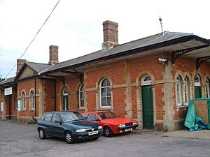
The LSWR's station (later called Chard Town) opened in 1860. The B&ER's station (called Chard Joint or Chard Central) opened in 1866. Passenger trains stopped running to Chard Central in 1962. The station building is still standing and is used by engineering companies.
Today, buses connect Chard to Taunton. Two routes, 30 and 99, run hourly during weekdays. There is also a bus service to Yeovil via Crewkerne.
Sports in Chard
Chard has several local sports clubs. Chard Town F.C. plays football in the Somerset County League. Other Chard football clubs play in the Perry Street and District League.
The Rugby union club, Chard RFC, started in 1876. They have three senior teams. The first team plays in South West One (west). Chard Hockey Club was founded in 1907. It now has three male and three female teams. Chard also has places for cricket, tennis, bowls, darts, and golf.
Education
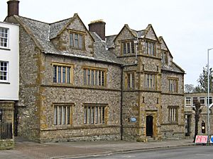
The original school building on Fore Street was built in 1583. It was a private home. In 1671, it became a grammar school. Today, it is known as Chard School. It is a private school for children aged 4 to 11.
For primary education, there are Avishayes Community Primary School, Manor Court Community Primary School, Tatworth Primary School, and The Redstart Primary School. Holyrood Academy provides secondary education. In 2019, the academy had 1,276 students aged 11 to 18.
Religious Sites
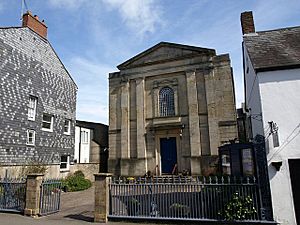
The Anglican Church of St Mary the Virgin was built in the late 11th century. It was rebuilt in the 15th century. The church tower has eight bells. Two of these bells were made in the 1790s. The church is a Grade I listed building, meaning it is very important historically. There is also a church room built in 1827. The Baptist Church on Holyrood Street was built in 1842.
Notable People from Chard
- John Strong: An early American colonist and politician. He helped found towns in Connecticut and Massachusetts.
- William Samuel Henson: An aviation engineer and inventor. He worked with John Stringfellow to achieve the first powered flight in 1848. This happened in an old lace factory.
- James Gillingham: He was a pioneer in developing artificial limbs.
- Corporal Samuel Vickery: He received the Victoria Cross in 1897 for his bravery in India.
- Margaret Bondfield: A Labour politician and feminist. She was the first woman Cabinet minister in the United Kingdom. She was born in Chard in 1873.
- Lucy Cox: An artist and curator. She has shown her work in many places around the world.
See also
 In Spanish: Chard (Inglaterra) para niños
 | Janet Taylor Pickett |
 | Synthia Saint James |
 | Howardena Pindell |
 | Faith Ringgold |


