Bridgwater and Taunton Canal facts for kids
Quick facts for kids Bridgwater and Taunton Canal |
|
|---|---|

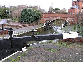
Firepool Lock, where the canal joins the River Tone
|
|
| Specifications | |
| Length | 14.5 miles (23.3 km) |
| Maximum boat length | 51 ft 10 in (15.80 m) |
| Maximum boat beam | 13 ft 7 in (4.14 m) |
| Locks | 7 (originally 6) |
| Original number of locks | 6 |
| Status | Navigable |
| Navigation authority | Canal and River Trust |
| History | |
| Original owner | Bridgwater and Taunton Canal Company |
| Principal engineer | James Hollinsworth |
| Date of act | 1811, 1824 |
| Date of first use | 1827 |
| Date completed | 1841 |
| Date closed | 1907 |
| Date restored | 1994 |
| Geography | |
| Start point | Taunton |
| End point | Bridgwater Docks |
| Connects to | isolated |
The Bridgwater and Taunton Canal is a canal in south-west England. It connects the towns of Bridgwater and Taunton. The canal opened in 1827. It links the River Tone to the River Parrett.
For a long time, people wanted to build a waterway across England. This would connect the Bristol Channel to the English Channel. It would help ships avoid the long and risky journey around Cornwall. The Bridgwater and Taunton Canal was part of a smaller plan. It aimed to link Bristol to Taunton by water.
In its early years, the canal faced many legal problems. These were solved when the Canal Company took over the River Tone Navigation. The canal first ended at a basin in Huntworth. Later, it was extended to a floating harbour at Bridgwater Docks. This extension cost a lot of money. Soon after, railways became popular. This caused the canal to lose business. The Bristol and Exeter Railway saved the canal from going bankrupt in 1866.
Commercial boats stopped using the canal in 1907. However, the canal was kept in good condition. From 1962, it was used to transport drinking water. The Countryside Act 1968 helped start the canal's restoration. It was reopened for leisure activities in 1994. Today, Bridgwater Docks is a marina. The canal still carries drinking water, so there is no boat connection to the River Parrett.
Contents
How the Canal Began
Before the canal, boats used the River Parrett and River Tone. The River Tone had been improved since 1699. People had straightened and deepened the river. They also built locks to control water levels.
Why Was the Canal Built?
From 1768, many big plans were suggested. The main goal was to create a waterway from the Bristol Channel to the English Channel. This would save ships from sailing around Cornwall and Devon. Famous engineers like James Brindley and William Jessop surveyed possible routes.
One idea was for a canal linking Bristol, Bridgwater, and Taunton. This was called the Bristol and Taunton Canal. An Act of Parliament approved it in 1811. However, the Napoleonic Wars made the economy bad. So, construction did not start right away.
Work finally began in 1822. But there were problems with the route. A new Act of Parliament in 1824 approved a shorter route. This new project was named the Bridgwater and Taunton Canal. It was much cheaper than the original long plan.
Other ideas for a Channel-to-Channel link came up. But people lost interest in huge canal projects. Steamships also made sea travel safer. So, the idea of a long cross-country canal was dropped.
Building the Canal
Construction of the canal started in 1822. James Hollinsworth was the engineer. The canal was designed to join the River Parrett at Huntworth. A basin was built there.
The canal was about 12 miles (19 km) long. It had a large 700-yard (640 m) embankment at Lyng. This was 40 feet (12 m) high. There were also two short cuttings. Eleven brick bridges carried roads over the canal. More than twelve wooden swing bridges were built for farms.
The canal had five locks on its main line. One lock at Firepool (Taunton) had special gates. These stopped the canal from draining if the River Tone's water level dropped. Another lock connected the Huntworth basin to the river. This lock also had special gates to drain the basin for maintenance. The canal's paddle gearing system, with metal ball and cylinder weights, is unique. Over fifty culverts were built to carry streams under the canal. The construction was finished safely.
By 1826, the Canal Company needed more money. They took out a mortgage to finish the work. The canal opened on January 3, 1827. The opening was delayed by snow and cold weather.
How the Canal Was Used
The canal's early years had many legal fights. The Canal Company and the Conservators of the River Tone argued. The Canal Company wanted to use the River Tone to reach Taunton. After several court cases, they finally agreed in 1831. A new Act of Parliament in 1832 allowed the Canal Company to buy the Tone Navigation.
At the Bridgwater end, connecting to the River Parrett was difficult. The Canal Company decided to build a floating harbour. They also extended the canal to reach it. This was approved in 1837. The work was expensive, costing nearly £100,000. Most of this money came from a mortgage.
The new harbour opened on March 25, 1841. It had two basins and locks. Trade increased after the harbour opened. About 2,400 vessels used the port each year by 1853. However, the high interest payments on the mortgage caused problems. In 1846, the company even got permission to turn the canal into a railway.
As railways grew, canal trade dropped by half. By the early 1850s, the company was in financial trouble. In 1866, the Bristol and Exeter Railway bought the canal and the dock for £64,000. The railway company saw the dock as very useful for coal transport. They were required to keep "good and sufficient water communication" between Taunton and Bridgwater. The canal was kept in good condition for several years.
When the Canal Declined
The canal started having problems with its water supply. Water came mainly from the River Tone. It was pumped into the canal at Creech. Large amounts of water were used to clean the Bridgwater Dock. The railway also took water for its station and steam trains in Taunton. In summer, there was often not enough water.
Weeds began to clog the canal. Railways took away most of the canal's business. Between 1870 and 1874, the canal's income dropped. In 1877, the Bristol and Exeter Railway joined the Great Western Railway. The new owners were less interested in the canal itself. They cared more about the water supply for Taunton station and Bridgwater Dock. The canal continued to get worse.
The opening of the Severn Tunnel in 1886 caused more decline. Coal and slate from South Wales could now be moved more directly by train. In 1902, the railway needed even more water for its trains. The last commercial boats used the canal in 1907. The canal was then effectively closed.
The Canal During Wartime
After the First World War, the canal was barely maintained. It became a place for fishermen and walkers. Its structures remained in good condition compared to many other closed canals. In the 1930s, parts of the canal were even used for swimming lessons.
During the Second World War, the canal was part of the Taunton Stop Line. This was a defensive line against invasion. Bridges were prepared with explosives for demolition. Anti-tank obstacles were placed at bridges and locks. All swing bridges were removed and replaced with fixed wooden bridges. Only essential maintenance was done to keep water for firefighting. Sadly, all company records were destroyed during a bombing raid.
After the war, the canal became publicly owned in 1947. Efforts to remove the fixed low-level bridges failed. The Inland Waterways Association became interested in restoring the canal from 1952. But the British Transport Commission locked the gates to prevent use. Still, a team of seven men maintained the canal. This maintenance allowed the canal to be used for transporting water. From 1962, water was pumped from the canal to Durleigh reservoir.
In 1962, the canal was taken over by the British Waterways Board. In 1968, it was classified as a "remainder waterway." This meant it was mainly a drainage channel. Only basic safety maintenance was planned. Part of a cutting wall collapsed in 1968. Bridgwater Docks closed in 1971. The canal was no longer maintained for boats.
Bringing the Canal Back to Life
From the late 1960s, people realized the canal's value. The Inland Waterways Association suggested it could become a "linear Country Park." Somerset County Council agreed to fund its maintenance and restoration. The Countryside Act 1968 provided a way to do this. Seeing restoration work on another canal convinced the Council.
By 1974, Higher and Lower Maunsel locks were refurbished. The County Council provided funding for towpath maintenance and weed cutting.
In December 1974, the Council bought Bridgwater Dock. By 1980, over £50,000 had been invested in restoration. This included Kings and Standards locks. Some bridges were raised, but only enough for canoes. Work on the deep cutting in Bridgwater started in 1978.
A plan to restore the canal was fully costed in 1983. It was adopted by several councils and the British Waterways Board. The Waterway Recovery Group offered to help. Swing bridges at Crossways, Boat and Anchor, and Fordgate were rebuilt. By 1987, 4.5 miles (7.2 km) of the canal was open for boats. Many other bridges were raised to allow 8 feet (2.4 m) of headroom. Restoration continued into the early 1990s. The canal finally reopened in 1994.
The Canal Today
Boating is encouraged on the canal. However, there is no connection to the River Parrett at Bridgwater. The Parrett is a salt water river with a lot of silt. The canal has fresh water. It's important to keep the salt water and silt out of the canal. This is because it still carries drinking water for Bridgwater. The canal also helps with flood control. In winter, it takes water from the River Tone and releases it into the Parrett.
Bridgwater Docks is now a marina. Its old warehouse has been turned into apartments. The canal's towpath is part of Sustrans' National Cycle Network route NCR-3. This route connects Bath and Cornwall. There are plans to improve the towpath and build a visitor center at Maunsel.
The Somerset Space Walk
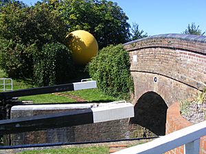
The Taunton-Bridgwater canal is also home to the 'Somerset Space Walk'. This is a scale model of our Solar System. The 'Sun' is at Maunsel Lock. The planets are placed along the towpath in both directions. Pip Youngman, a local man, designed the Space Walk. It helps people understand the huge scale of the Solar System. You can walk from Taunton to Maunsel Lock (Pluto to the Sun). Or you can walk from Bridgwater to Maunsel Lock (also Pluto to the Sun). Each walk from Pluto to the Sun is about 11-kilometre (6.8 mi).
Canal Route Highlights
| Point | Coordinates (Links to map resources) |
OS Grid Ref | Notes |
|---|---|---|---|
| Firepool Lock | 51°01′19″N 3°05′53″W / 51.022°N 3.098°W | ST230253 | Where the canal meets the River Tone |
| Chard Canal Junction | 51°01′34″N 3°02′35″W / 51.026°N 3.043°W | ST269256 | Old junction, no longer used |
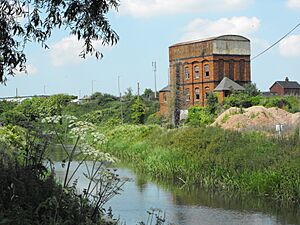
| Creech Pumping Station | 51°01′48″N 3°01′05″W / 51.030°N 3.018°W | ST287261 | Old pumping station, now derelict |
| Higher Maunsel Lock | 51°03′32″N 2°59′20″W / 51.059°N 2.989°W | ST307293 | |
| Lower Maunsel Lock | 51°03′47″N 2°59′20″W / 51.063°N 2.989°W | ST307297 | |
| Kings Lock | 51°04′37″N 2°59′35″W / 51.077°N 2.993°W | ST305313 | |
| Standards Lock | 51°04′52″N 2°58′37″W / 51.081°N 2.977°W | ST316317 | |
| Fordgate swing bridge | 51°05′20″N 2°58′12″W / 51.089°N 2.970°W | ||
| Huntworth Basin | 51°06′54″N 2°59′13″W / 51.115°N 2.987°W | ST309355 | Old basin, no longer used |
| Bridgwater Docks | 51°07′55″N 3°00′18″W / 51.132°N 3.005°W | ST297375 | No connection to River Parrett |
 | Frances Mary Albrier |
 | Whitney Young |
 | Muhammad Ali |


