
Gwennap Head facts for kids
Quick facts for kids Gwennap Head
|
|
|---|---|
 Granite cliffs at Gwennap Head (Tol-Pedn-Penwith) near Porthgwarra |
|
| Lua error in Module:Location_map at line 530: Unable to find the specified location map definition: "Module:Location map/data/Cornwall (mainland)" does not exist. | |
| OS grid reference | SW365217 |
| Unitary authority | |
| Ceremonial county | |
| Region | |
| Country | England |
| Sovereign state | United Kingdom |
| Postcode district | TR19 |
| Police | Devon and Cornwall |
| Fire | Cornwall |
| Ambulance | South Western |
| EU Parliament | South West England |
Gwennap Head is a beautiful piece of land that sticks out into the sea in Cornwall, United Kingdom. Its Cornish name is Cornish: Toll Pedn Pennwydh, which means holed head of Penwith. You can find it on the south coast of the Penwith peninsula.
Gwennap Head is part of the St Levan area. It's about 4 kilometres (2.5 miles) south of Land's End. The small village of Porthgwarra is less than 1.6 kilometres (1 mile) away. This whole area is very special. It's part of the Penwith Heritage Coast. It's also part of the Cornwall Area of Outstanding Natural Beauty. This means it's a protected place because of its amazing natural beauty. The South West Coast Path walking trail goes right around the headland.
The cliffs here are made of strong granite. They are famous for a climbing spot called Chair Ladder. Many climbers, from beginners to experts, love to visit this area. The older and more correct name for this headland is Tol-Pedn-Penwith. People often call it "Tol-Pedn" for short. This name comes from the Cornish words for 'the holed headland of Penwith'. It refers to an amazing hole that goes from the top of the cliff down to a sea cave. Around 1888, the name changed to Gwennap Head. It might have been named after a local family.
The sea near Gwennap Head is busy with all kinds of ships. There is a Coastwatch station right on the headland. It's in an old coastguard building. Many naturalists also love this area. At certain times of the year, they can spot rare animals. These include the red-billed chough (Pyrrhocorax pyrrhocorax). You might also see great shearwater (Puffinus gravis), basking shark, and ocean sunfish (Mola mola).
Contents
History of Gwennap Head
In the past, Tol Pedn was sometimes called Land's End. In the early 1800s, it was often known as St Leven's Land's End. This helped people tell it apart from the Land's End we know today. That one was called Sennen Land's End. Even Cape Cornwall was sometimes known as Land's End!
It seems that Tol-pedn used to be a bigger area than just the headland we call Gwennap Head today. In 1824, a writer named Hitchens said that ″Tolpedn-Penwith is divided from the mainland by an ancient stone wall″. He thought this wall might have been for defence. Today, a stone wall still exists to the north. It reaches the sea near Black Carn. It looks more like a boundary or a wall for animals, not for defence. Hitchens also mentioned other signs of old forts in the area.
In the 1840s, H McLauchlan reported seeing faint traces of a Bronze Age burial mound. This was at the top of Tol-pedn-Penwith. But today, there are no signs of it. The highest point is now where the NCI Coastwatch station stands. Some people thought there might have been a cliff castle here. But this is unlikely because there are no traces. Also, the spot isn't really suitable for a castle.
Shipwrecks and Rescues
On the north side of Gwennap Head, a stream flows into Porth Loe. This is a small cove filled with boulders. On March 14, 1905, a ship called the Kyber was seen heading towards The Lizard. The next morning, the ship was found crashing ashore at Porth Loe. It broke apart in just fifteen minutes. Men who were building the nearby coastguard houses used ladders to save three of the crew. Sadly, twenty-three other crew members are buried in a mass grave. This grave is in St Levan churchyard.
The land around Gwennap Head is owned by the St Aubyn Estate.
Watching the Coast: NCI Coastwatch

People have been watching ships from Gwennap Head for hundreds of years. In the museum at Truro, there's a photo of a signal station on Tol-pedn. The flag in the photo shows it was there before 1801. Old maps also show a station here. A photo from around 1900–1910 shows a two-arm signal system.
The main building you see today was started around 1905. It was a one-storey Coastguard lookout station. It opened by 1910. A second floor was added later to make the watch room taller. This happened after a French fishing boat crashed at the bottom of Wireless Point, Porthcurno. This was on March 14, 1956. The Vert Prairial couldn't be seen from the station when it wrecked. Seventeen crew members lost their lives. The coastguard station closed in 1994. But it reopened on October 21, 1996, as NCI Gwennap Head. It's now run by volunteers.
Guiding Ships: Day Marks

There are two cone-shaped markers on Gwennap Head. They help guide ships away from a dangerous underwater rock called the Runnel Stone. These are called day markers. The cone closer to the sea is painted red. The one further inland is black and white.
Sailors at sea must always keep the black and white cone in sight. This helps them avoid rocks closer to the shore. If the red cone completely blocks the view of the black and white cone, it means the ship is directly over the Runnel Stone. The black and white marker was put up by the Corporation of Trinity House in 1821. A plaque on the back of the marker records this event. Between 1880 and 1923, over thirty steamships were wrecked or sank in this area. Since 1923, there have been no more shipwrecks here.
The navigation markers are even mentioned in a book! They appear as "the Cones of Runnel" in Hammond Innes's 1940 thriller, "The Trojan Horse."
Wildlife at Gwennap Head
Gwennap Head is part of a special area called the Porthgwarra to Pordenack Point Site of Special Scientific Interest (SSSI). It's protected for its unique plants and its importance for birds. Many birds pass through here during their migrations. Birdwatchers love this headland. Many travel from all over Britain to see rare seabirds.
Amazing Seabirds
You can see many common seabirds here. These include the northern gannet (Morus bassanus) and Manx shearwater (Puffinus puffinus). Also, common guillemot (Uria aalge) and razorbill (Alca torda). You might also spot northern fulmar (Fulmarus glacialis), shag (Phalacrocorax aristotelis), and cormorant (Phalacrocorax carbo).
In July and August, you might see two large types of shearwaters. These are the great shearwater and the Cory's shearwater (Calonectris diomedea). Great shearwaters breed in the South Atlantic. Cory's shearwaters breed in the Mediterranean and on islands in the North Atlantic. Many birds follow the coast as they fly north in spring to breed. They also fly south in autumn to spend winter in warmer places.
Migrating Birds and More
At Gwennap Head, many waders, ducks, larks, and finches are seen. This is especially true during peak migration times in May and October. Choughs (Pyrrhocorax pyrrrocax) have been breeding successfully on Gwennap Head. However, in May 2015, they lost their young to a predator.
From 2007 to 2011, a project called Seawatch SW took place here. Volunteers spent up to twelve hours a day watching the sea. They recorded how many of certain species they saw. The main birds they looked for were Balearic shearwater (Puffinus mauretanicus). They also watched for basking sharks and ocean sunfish. They also looked for marine mammals like whales, dolphins, and grey seal (Halichoerus grypus). On August 28, 2015, a very rare bird was seen. A red-billed tropicbird (Phaethon aethereus) was spotted over the Runnel Stone. This bird usually lives in tropical areas!
Plants and Flowers
Gwennap Head is part of the Land's End granite area. The soil here is shallow, drains easily, and is acidic. The main plants on the heathland are heather (Calluna vulgaris), bell heather (Erica cinerea), and western gorse (Ulex gallii).
Near the cliff edges, there is maritime grassland. Here you can find some rare plants. These include perennial centaury (Centaurium scilloides) and early meadow-grass (Poa infirma). You might also see the rare hairy bird's-foot trefoil (Lotus subbiflorus) and yellow bartsia (Parentucellia viscosa). The grassland is very colourful in spring and early summer. You can see spring squill, thrift, sea campion, and kidney vetch in bloom. Later in summer, the heathland turns purple and yellow.
In 2010, the perennial centaury was found again by Helen and Laurie Oakes. This plant is very rare in Britain. It hadn't been seen in Cornwall (or England) since 1962. It only survived in one place in Wales. This re-discovery happened after cattle were brought back to graze the land. This grazing helps the special plants grow.
Butterflies and Moths
Many butterflies live at Gwennap Head. These include the large white (Pieris brassicae) and small copper (Lycaena phlaeas). You can also see the common blue (Polyommatus icarus) and small tortoiseshell (Aglais urticae). Other butterflies are the peacock (Aglais io) and comma (Polygonia c-album). Look out for the small pearl-bordered fritillary (Boloria selene) and speckled wood (Pararge aegeria). The grayling (Hipparchia semele) and wall (Lasiommata megera) are also here.
Just like birds, some insects also migrate. Butterflies often seen migrating here include the clouded yellow (Colias croceus). You might also spot the red admiral (Vanessa atalanta) and painted lady (Vanessa cardui). Migrant moths include the rush veneer (Nomophila noctuella). Also, the rusty-dot pearl (Udea ferrugalis). And the hummingbird hawk-moth (Macroglossum stellatarum) and silver Y (Autographa gamma).
Runnel Stone Marine Conservation Zone
The Runnel Stone Marine Conservation Zone is a special protected area in the sea. It's also known as Land's End (Runnel Stone). It was set up on January 29, 2016. This zone covers 20 square kilometres (7.7 square miles). It stretches out from the NCI lookout station. It includes much of the coast from Gwennap Head to Hall Dinas. This is on the east side of Treryn Dinas. This zone protects deep sea rocks on the Runnel Stone reef. It also protects other important places. These range from exposed rocks on the coast to soft sand on the sea floor.
Images for kids
-
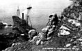
The cargo steamship J Duncan wrecked on Gwennap Head in 1913
.jpg)
