
Land's End facts for kids
Quick facts for kids Land's End
|
|
|---|---|
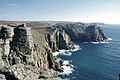
 Cliffs at Land's End, showing Dr Syntax Head and Longships Lighthouse |
|
| Lua error in Module:Location_map at line 530: Unable to find the specified location map definition: "Module:Location map/data/Cornwall (mainland)" does not exist. | |
| OS grid reference | SW 34177 25339 |
| Unitary authority | |
| Ceremonial county | |
| Region | |
| Country | England |
| Sovereign state | United Kingdom |
| Post town | PENZANCE |
| Postcode district | TR19 |
| Dialling code | 01736 |
| Police | Devon and Cornwall |
| Fire | Cornwall |
| Ambulance | South Western |
| EU Parliament | South West England |
| UK Parliament |
|
Land's End (in Cornish: Penn an Wlas or Pedn an Wlas) is a famous headland and a fun place for tourists in western Cornwall, England. It's part of the Penwith peninsula, about 8 miles (13 km) west-south-west of Penzance. This spot marks the very end of the A30 road. To its east is the English Channel, and to its west is the Celtic Sea.
Land's End is the most westerly point of mainland England. However, it's not the most westerly point in all of Great Britain. That title belongs to Corrachadh Mòr in the Scottish Highlands.
Contents
Exploring Land's End: Geography and Views
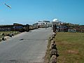
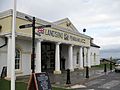
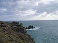
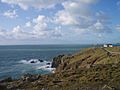
The actual Land's End, also called Peal Point, is a small headland. Nearby, you can find bigger headlands like Pedn-men-dhu, which looks over Sennen Cove, and Pordenack to the south. The hotel and tourist area you see today are a bit south of the exact Land's End spot.
Land's End is famous for showing how far away places are. For example, the distance from Land's End to John o' Groats in Scotland is about 838 miles (1,349 km) by road. This "Land's End to John o' Groats" journey is often used for charity walks and races across the UK.
Special Rocks and Names
The westernmost part of Land's End is called Dr Syntax's Head. This name comes from a funny character created by writer William Combe in 1809. Another nearby rock is named Dr Johnson's Head, after Samuel Johnson. He wrote about a made-up idea of Cornwall becoming independent in 1775.
Nature's Beauty
The area around Land's End is very important for nature. It's been named an Important Plant Area by Plantlife because of its rare plants. It's also a popular spot for people who enjoy rock climbing.
Just over 1 mile (1.6 km) offshore are the Longships, a group of rocky islands. These islands, along with the Seven Stones Reef and the Isles of Scilly (about 28 miles or 45 km southwest), are part of the mythical lost land of Lyonesse. This land is often mentioned in stories about King Arthur.
The Story of the Rocks: Geology
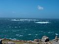
The cliffs at Land's End are made of granite, which is a very strong rock formed from cooled lava. This means the cliffs are tough and have steep, tall faces. There are two types of granite here. Near the hotel, the granite has large crystals, some more than 5 inches (13 cm) long! Further north, near the First and Last House, the granite has smaller crystals. You can even see the difference from a distance.
These granite rocks are very old, formed about 268–275 million years ago during the Permian period. The Longships Lighthouse, which is offshore, is built on a different type of rock that touches the granite area.
A Journey Through Time: History of Land's End
People have been visiting Land's End for over 300 years! In 1649, an early visitor was the poet John Taylor.
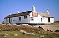
By 1878, tourists would travel from Penzance in horse-drawn carriages to see the sights. They would stop to look at Porthcurno and the Eastern Telegraph Company, then get refreshments at the First and Last Inn in Sennen. After that, they would head to Land's End, often walking or riding horses because the paths were rough. More than a hundred people could be at Land's End at one time!
The First and Last Inn owned a small house at Carn Kez where visitors could leave their horses while they explored the cliffs. This small house eventually grew into the hotel we see today. During World War II, the hotel was damaged by bombs from a German plane. Later, American troops stayed there before D-Day, leaving the building in poor condition.

A Cornish family owned Land's End until 1982. Then, in 1987, Peter de Savary bought it for almost £7 million. He added new buildings and started many of the theme park attractions you see now. He later sold Land's End in 1991. The current owners bought it in 1996 and formed a company called Heritage Great Britain PLC.
Today, the theme park has playgrounds for kids and plays music. In August, Land's End hosts a special event called 'Magic in the Skies'. This is a night-time firework show with music and narration. The Land's End Hotel is also part of the complex.
In May 2012, Land's End became famous worldwide as the starting point for the 2012 Summer Olympics torch relay.
Epic "End to End" Journeys
Land's End is often the start or finish line for amazing "end to end" journeys to or from John o' Groats in Scotland. One of the earliest recorded journeys was by Carlisle in 1879. He left Land's End, went to John o' Groats, and came back to Land's End, covering 3,899 miles (6,275 km) in 72 days! He kept a log book stamped at post offices to prove his journey.
Early bicycle journeys were also made. In 1880, Messrs Blackwell and Harman cycled 900 miles (1,448 km) in thirteen days. A couple of years later, Hon I Keith-Falconer cycled 994 miles (1,600 km) from Land's End in just under thirteen days.
Gallery
-
Cliffs at Land's End
-
The tourist centre at Land's End
-
The tourist centre at Land's End
-
The old refreshment house
-
The Longships Lighthouse off Land's End
-
Looking south from Land's End
-
Looking west from Land's End
-
Looking north from Land's End
-
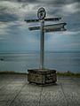
Signpost at Land's End


.jpg)

.jpg)
.jpg)
.jpg)

See also
 In Spanish: Land's End para niños
