
Cape Cornwall facts for kids
Quick facts for kids Cape Cornwall
|
|
|---|---|
 Headland of Cape Cornwall |
|
| Lua error in Module:Location_map at line 530: Unable to find the specified location map definition: "Module:Location map/data/Cornwall (mainland)" does not exist. | |
| OS grid reference | SW371315 |
| Unitary authority | |
| Ceremonial county | |
| Region | |
| Country | England |
| Sovereign state | United Kingdom |
| Post town | PENZANCE |
| Postcode district | TR19 7 |
| Dialling code | 01736 |
| Police | Devon and Cornwall |
| Fire | Cornwall |
| Ambulance | South Western |
| EU Parliament | South West England |
| UK Parliament |
|
Cape Cornwall (in Cornish: Kilgoodh Ust, meaning "goose back of St Just") is a small piece of land that sticks out into the sea in West Cornwall, UK. It is about four miles north of Land's End, close to the town of St Just. For a long time, until about 200 years ago, people thought Cape Cornwall was the most western point in Cornwall.
Most of this headland is owned by the National Trust, an organization that protects special places. The National Coastwatch Institution also has a lookout station here to watch over the sea. For visitors, there's a car park, public toilets, and a small shop selling refreshments in the summer.
The Brisons are two rocks in the sea, about one mile southwest of Cape Cornwall. They are the starting point for a yearly swimming race that finishes at Priest Cove.
Contents
What's in a Name?
The name Cape Cornwall first appeared on a map around the year 1600. The original Cornish name, Kilgoodh Ust, is not used much anymore. In English, it means "goose-back at St Just," which describes the shape of the cape. Another Cornish name, Pen Kernow, is a newer translation from the English name.
A "cape" is a point of land where two large bodies of water meet. Cape Cornwall is one of only two capes in the United Kingdom. The other one is Cape Wrath in Scotland.
History of Cape Cornwall
_edit.jpg)
People have lived around Cape Cornwall for a very long time. Pottery found here shows that people were living on the Cape during the Late Bronze Age. There's also another old fort nearby, which suggests this area was important during the Iron Age.
On the land side of the Cape, you can see the remains of a medieval church called St Helen’s Oratory. This church was built on the site of an even older church from the 6th century. A special stone bowl used for baptisms, now in St Just church, might have come from this old building.
From Mines to Monuments

A tin mine called Cape Cornwall Mine operated on the cape from 1838 to 1883. The mine's tall chimney, built in 1864, was kept even after the mine closed. It became a useful landmark for ships at sea.
In the early 1900s, the areas where the mine used to process ore were turned into greenhouses and places for making wine.
In 1987, the H. J. Heinz Company bought the old mine site. They then gave it to the nation as a gift. The remains of Cape Cornwall Mine are now part of the Cornwall and West Devon Mining Landscape. This whole area is a UNESCO World Heritage Site, which means it's a very important place for everyone in the world to protect.
Images for kids
-
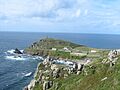
Headland of Cape Cornwall
-
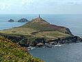
Heinz Monument (the 1864 chimney of the former Cape Cornwall Mine) stands tall. You can also see the ruins of St. Helen's Oratory and the two rocks called The Brisons in the distance.
-
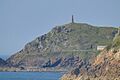
Cape Cornwall's beautiful coastline.
See also
 In Spanish: Cabo Cornualles para niños
