
Newport Wetlands facts for kids
Quick facts for kids Newport Wetlands |
|
|---|---|
| Gwlyptiroedd Casnewydd | |

|
|
| Lua error in Module:Location_map at line 420: attempt to index field 'wikibase' (a nil value). | |
| Type | National nature reserve |
| Nearest city | Newport, Wales |
| Area | 437 hectares (1,080 acres) |
| Created | 2000 |
| Operated by |
|
Newport Wetlands is a fantastic wildlife reserve in South Wales. It's located near the city of Newport. This special place covers parts of Uskmouth, Nash, and Goldcliff. It's a wonderful spot for both people and animals to enjoy nature.
Contents
A Home for Wildlife
Newport Wetlands was created in the year 2000. It was built to help make up for the loss of animal homes. This happened when the Cardiff Bay Barrage scheme was built. The barrage changed the natural areas where many animals lived.
The reserve is looked after by Natural Resources Wales. It is also managed by the Royal Society for the Protection of Birds (RSPB). They opened a special visitor and education centre in 2008. This centre helps people learn about the wetlands. It also helps protect the animals that live there.
The reserve covers a huge area of 437 hectares (1,080 acres). This land is part of the Caldicot and Wentloog Levels. This is a low-lying area next to the Severn Estuary. Part of the reserve used to be a place for disposing of fuel ash. Some farmland was also flooded to create the wetlands. Newport Wetlands became a national nature reserve on April 16, 2008.
Visiting Newport Wetlands

It's free to enter Newport Wetlands. The car park is open every day from 9:00 am to 5:00 pm. The visitor and education centre is open every day except Christmas Day.
What to Do at the Visitor Centre
The visitor centre has many helpful things. You can find a shop, refreshments, and bathrooms there. There are also places to watch birds from inside. You can even join guided tours to learn more about the reserve.
Exploring the Reserve
You can bring your dogs and bikes to certain areas. There's a special 6-kilometre (3.7 mi) circular path. This path goes around the edge of the reserve. It starts near the car park and heads west. It then goes past the power station and the East Usk Lighthouse. The path continues along the Severn Estuary.
After a while, the path splits. One path goes back to the visitor centre. This is for walkers and dog owners. A longer path continues towards Goldcliff village. This route is great for both walkers and cyclists.
Play and Picnic Areas
Right next to the visitor centre, there's a picnic and play area. This area has a fun play space for children. It also has an education zone where you can learn new things. There are benches where you can sit and enjoy a picnic.
Trails and Views
The main trail leads towards the Severn Estuary. From here, you can see the East Usk Lighthouse. There's also a bird hide overlooking Lagoon R9. This is a great spot to watch birds without disturbing them.
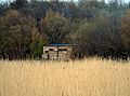
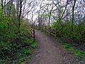
There is also a woodland trail. You can enter it by turning left at the top of a hill. This trail goes through the reserve's woodlands. It passes a viewing platform that looks over Lagoon R8. The woodland trail eventually connects to the estuary trail.
-
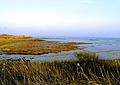
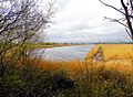
View of Severn Estuary Rocks From Newport Wetlands RSPB Reserve
-
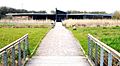
Newport Wetlands RSPB Reserve visitor centre as seen from picnic and play area
-
Visitor centre and picnic and play area seen from hill
-

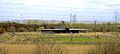
View of Uskmouth power station
-
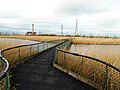
Floating walkway facing northwards
-
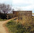
Entrance to the hide
-
Frontal exterior to the hide
-
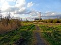
Cycle path alongside power station
-
Viewing platform
-
Lagoon R8 overlooked by viewing platform


Amazing Wildlife: Flora and Fauna
Newport Wetlands has many different types of habitats. These include grazed pastures, reed beds, and grasslands. These different areas attract a wide variety of animals.
Birds and Their Reproduction
Many birds come here to breed. You might see lapwings, redshanks, and oystercatchers. Other breeding birds include little ringed plovers and ringed plovers.
In winter, many birds visit the wetlands. These include wigeons, northern shovelers, and teals. You might also spot shelducks and pintails. Look out for hen harriers and short-eared owls too.
A very exciting event happened in 2020. Two pairs of bitterns successfully bred at the reserve. This was the first time in over 200 years that bitterns bred in south Wales! The Goldcliff Lagoons are also special. They are the only place in south Wales where avocets breed.
-
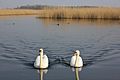
Mute swans with male and female tufted ducks in the background
-
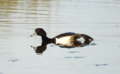
Tufted duck near Newport Wetlands RSPB Reserve visitor centre/picnic and play area
-
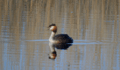
Great crested grebe calling on Newport Wetlands RSPB Reserve fenced lagoon
-
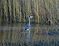
Grey heron fishing on Newport Wetlands RSPB Reserve fenced lagoon
-

Tufted ducks at Newport Wetlands RSPB Reserve floating walkway
-
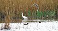
Little egret and teal ducks on Lagoon near the hide at Newport Wetlands RSPB Reserve


Floating Walkway
The reserve has a special floating walkway. This walkway gives you a direct path to the lighthouse. It goes over Lagoon R7. This lagoon is one of three lagoons along the coastal path. You can view Lagoon R9 from a bird hide. Lagoon R4 can be seen from a fenced overpass.
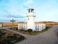
East Usk Lighthouse
 |
|
| East Usk lighthouse, near Perry Lane, West Nash, Newport | |
| Location | Uskmouth Newport Wales United Kingdom |
|---|---|
| Coordinates | 51°32′24″N 2°58′01″W / 51.54000°N 2.96696°W |
| Year first constructed | 1893 |
| Construction | cast iron tower |
| Tower shape | cylindrical tower with balcony and lantern |
| Markings / pattern | white tower and lantern |
| Height | 13 metres (43 ft) |
| Focal height | 11 metres (36 ft) |
| Characteristic | Fl (2) WRG 10s. |
| Admiralty number | A5454 |
| NGA number | 5904 |
| ARLHS number | WAL-005 |
The East Usk Lighthouse is located within the reserve. You can find it along the estuary trail. It faces towards the Severn Estuary. This lighthouse is a simple structure that holds a lamp. It does not have any living quarters.
On the other side of the River Usk is the West Usk Lighthouse. This lighthouse is no longer used for navigation. It has been turned into a hotel. You can see it from the reserve.
-
East Usk Lighthouse at Newport Wetlands RSPB Nature Reserve facing east towards bird hide

