Goldcliff facts for kids
Quick facts for kids Goldcliff
|
|
|---|---|
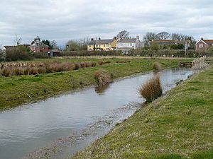 A reen in Goldcliff with The Farmer's Arms beyond |
|
| Population | 329 (2011 census) |
| Principal area | |
| Ceremonial county | |
| Country | Wales |
| Sovereign state | United Kingdom |
| Post town | NEWPORT |
| Postcode district | NP18 |
| Dialling code | 01633 Maindee exchange |
| Ambulance | Welsh |
| EU Parliament | Wales |
| UK Parliament |
|
| Welsh Assembly |
|
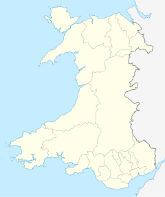
Goldcliff (called Allteuryn in Welsh) is a small village in South Wales. It's located southeast of the city of Newport. Goldcliff is part of Newport city and is found in the historic area of Monmouthshire. It's also part of the larger Gwent area. The village of Whitson is included in the Goldcliff community. In 2011, about 329 people lived here.
Contents
What's in a Name?
The name Goldcliff comes from a special cliff near Hill Farm. This cliff is about 60 feet (18 meters) tall. It's made of shiny limestone and yellow mica. When the sun hits it, it sparkles, especially for ships sailing in the Bristol Channel. An old traveler named Giraldus Cambrensis visited in 1188. He called it "Gouldclyffe" and said it "glittered with a wonderful brightness."
Life in Goldcliff: A Unique Landscape
Goldcliff is one of "The Three Parishes" along with Nash and Whitson. These three areas have always been connected. They are all typical of the Caldicot Levels. This means the land is very flat and low. At high tide, parts of the village are actually below sea level!
Waterways and Drainage
The whole area has many ditches called 'reens'. These reens help drain water from the land. A main ditch, called "Monksditch" or "Goldcliff Pill," flows through the village to the sea. Some local stories say that smugglers used to hide brandy along the sides of Monksditch.
Smaller ditches called grips run across the fields. These grips drain into the reens. The reens move slowly and can get still in summer. They empty into the sea at a gout when the tide is out. Special gates called stanks control the water levels in the reens. This keeps enough water for farm animals to drink.
The Sea Wall
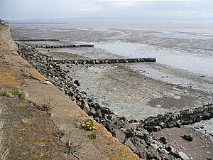
The southern edge of the village is next to the Severn Estuary. A tall concrete sea wall protects the land from the sea. This wall allows farmers to grow crops on the land behind it. You can also see structures called groynes at low tide. These are built to stop sand and pebbles from being washed away by the waves.
Goldcliff's Ancient History
Goldcliff has a very long history, with many old discoveries. The coastal area near the village has been important for archaeologists. People called the Silures lived here a long, long time ago.
Footprints from the Past
On the muddy foreshore of the Severn estuary, you can find 8,000-year-old human footprints! These footprints are from the Mesolithic period (Middle Stone Age). An archaeologist named Martin Bell helped find them. His work at Goldcliff was even shown on the TV show Time Team in 2004. In 2020, he explained the footprints on the BBC show Countryfile.
Iron Age Buildings and Roman Connections
After big storms in 1990, eight large Iron Age buildings were found near the coast. These buildings are about 2,200 years old. They might have been a special fishing spot for a short time. The wood used to build them still showed marks from iron axes.
Goldcliff also has links to the Romans. In 1878, a special stone was found near Goldcliff Point. It was called the "Goldcliff Stone." This stone showed that Roman soldiers had worked on a large earth wall, probably a sea wall.
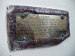
    1606
ON THE XX DAY OF IANVARY EVEN AS IT CAME TO
PAS IT PLEASED GOD THE FLVD DID FLOW TO THE
EDGE OF THIS SAME BRAS • AND IN THIS PARISH
THEARE WAS LOST 5000 AND ODD POWNDS BESIDES
XXII PEOPLE WAS IN THIS PARRISH DROWND
GOLDCLIF  {JOHN WILKINS OF PILREW AND
           WILLIAM TAP CHURCHWARDENS
1609Medieval Times and the Great Flood
Originally, Goldcliff was owned by Welsh princes. But around 1113, a Norman nobleman named Robert de Chandos took it over. He then started a priory (a type of monastery) there.
The higher parts of the coast were likely used for farming by the 1100s. The Benedictine priory helped drain and enclose the lower lands by the 1200s and 1300s.
Goldcliff is one of the few villages shown on a map of Wales from 1573.
A brass plaque in St Mary's Church tells about the Great Flood of 1607. A huge storm surge swept along the Bristol Channel, and about 2,000 people drowned. The plaque, which is about three feet above the floor, shows how high the water reached in the church. It also says that 22 people in Goldcliff drowned and over £5,000 was lost. The year 1606 is shown because the new year used to start on March 25th back then.
Goldcliff Priory
Goldcliff Priory was located on a high spot near the sea, where Hill Farm is today. It was founded in 1113 by the Abbey of Bec in France. Later, it was controlled by Tewkesbury Abbey and then Eton College.
Other Historic Spots
On Chapel Lane, there's a small area that might be the remains of an old chapel. This chapel was probably connected to the Priory. The farmhouse and barn at Great Newra Farm are also old buildings that are protected.
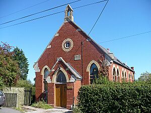
The old Congregational Chapel, built in 1840, is now a private home. It used to be a church until the 1980s.
South of the village, on the mudflats, you can see remains of anti-tank defenses from World War II. These concrete blocks were built to stop tanks if Germany tried to invade from Ireland.
Local Life and Learning
Goldcliff has a long history of putcher fishing for salmon. This special way of fishing used large baskets called "putchers" made from hazel and willow. These baskets were set out in the water to catch fish. This fishing method might have started with the Priory or even in Roman times. The last person to make these wooden putchers in Goldcliff was George Whittaker. The fishery stopped operating in 1995.
Village School and Businesses
Goldcliff and Whitson used to share a school. It was built in 1872 for 60 children. In 1901, about 46 children attended. The school closed in July 1954.
An old directory from 1901 lists many businesses in Goldcliff. Most were farmers, but there was also a haulier (someone who transports goods), two fishermen, a pub owner, a hay dealer, a mason, and a shoe maker. There was even a "Temperance Hotel" which was a well-known place until the 1950s.
The Village Church
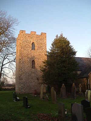
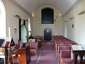
The village church is called Saint Mary Magdalene. You walk through a path lined with trimmed lime trees to reach it. The church is built in an old English style. In the churchyard, you can see parts of an ancient cross. Church records go back to 1724.
The church has a main hall (nave), a special area for the altar (chancel), a tower, and a porch. Most of it was built in the early 1400s. However, some parts, like the nave, seem even older, from the 1100s. This might mean parts of an earlier building were used again. The tower was probably added later, in the 1700s or 1800s. It has one bell.
Inside the church, near the altar, there's a small brass plaque. It remembers the Great Flood of 1607. The plaque shows how high the floodwaters reached. It also says that 22 people in the parish drowned and a lot of money was lost. The church was redecorated in 2006, and the old pews were removed.
Things to Do in Goldcliff
Goldcliff is home to part of the large Newport Wetlands nature reserve. This reserve opened in 2000. It was created to make up for the loss of mudflats when the Cardiff Bay Barrage was built. Parts of Goldcliff and Whitson are special protected areas for nature.
Goldcliff Lagoons and Wildlife
The Goldcliff Lagoons were made in the late 1990s. They are at the eastern end of the reserve. Many different wading birds live here, like lapwings, little ringed plovers, oystercatchers, redshanks, and avocets. Avocets are special because this is the only place in South Wales where they breed.
Village Life and Activities
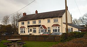
The village has a pub called The Farmers Arms, which is near the church. There's also a community room in the Old School building.
A public bus service (Route 63) serves the village twice a day on weekdays. The local newspaper is the South Wales Argus.
Goldcliff is a popular place for sea fishing and birdwatching. You can also find tea rooms with toilets near the seawall.
 | Kyle Baker |
 | Joseph Yoakum |
 | Laura Wheeler Waring |
 | Henry Ossawa Tanner |


