Gwent (county) facts for kids
| Gwent | |
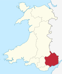
 Gwent shown within Wales as a preserved county |
|
| Geography | |
| Status | Non-metropolitan county (1974–1996) Preserved county (1996–) |
| 2003 area | 1,553 km² |
| 2022 area | 1,551 km² (5th) |
| HQ | Shire Hall, Newport (1974–1978) County Hall, Cwmbran (1978–1996) |
| History | |
| Created | 1974 |
| Abolished | 1996 |
| Succeeded by | Blaenau Gwent Caerphilly Monmouthshire Newport Torfaen Preserved county of Gwent |
| 2022 population | 591,396 (1st) |
Quick facts for kids Politics |
|
|---|---|
| Governance | Gwent County Council (1974–1996) |
Gwent is a special area in southeast Wales. It used to be a local government county, which means it had its own council that managed things like schools and roads. Now, Gwent is a "preserved county." This means its name is still used for certain official and ceremonial events, even though it doesn't have its own council anymore.
Contents
What is Gwent?
Gwent is located in the southeastern part of Wales. It's known for its beautiful landscapes and rich history. While it no longer has a local government council, the name Gwent is still very important. It helps people remember the area's past and is used for many organizations today.
Gwent's History
Gwent has a long and interesting history. Its name comes from an ancient kingdom that existed in this part of Wales a very long time ago.
How Gwent Was Formed
The county of Gwent was officially created on April 1, 1974. This happened because of a law called the Local Government Act 1972. Before 1974, this area was mostly part of a county called Monmouthshire and a large town area called Newport. The new Gwent county took over from these older areas.
Changes Over Time
In 1996, another law, the Local Government (Wales) Act 1994, changed things again. The county of Gwent, as a local government area, was stopped. Instead, the area was divided into several smaller, independent local councils. These new councils are called unitary authorities.
Gwent Today
Even though Gwent doesn't have its own council anymore, its name is still used in many ways.
What is a Preserved County?
A "preserved county" is an area that keeps its name for special, non-government purposes. For Gwent, this means its name is used for things like the Lieutenancy and High Shrievalty. These are important official roles that represent the King or Queen in the area.
Gwent's Local Councils
When the county of Gwent was divided in 1996, five new local councils were created. These are:
- Blaenau Gwent
- Caerphilly (part of which used to be in a different county called Mid Glamorgan)
- Monmouthshire (which covers a large part of the historic Monmouthshire area)
- Newport
- Torfaen
These councils now manage local services for the people living in their areas.
Gwent's Size and Population
In 2003, the preserved county of Gwent became a bit larger. It now includes the whole of the Caerphilly County Borough. The police force for the area, Gwent Police, had already changed its boundaries to match this in 1996.
In 2022, the population of Gwent was about 591,396 people. This makes it the most populated of the preserved counties in Wales. The area of Gwent is about 1,551 square kilometers.
Where Can You Find the Name Gwent?
The name "Gwent" is still very common in the area. You'll see it in the names of many important organizations and places, such as:
- Gwent Police: The police force that keeps people safe in the area.
- Royal Gwent Hospital: A major hospital that provides healthcare.
- Gwent Wildlife Trust: An organization that works to protect nature and wildlife.
- Coleg Gwent: A college where students can continue their education.
Sometimes, people also use "Gwent" to talk about the historic county of Monmouthshire, showing how important the name is to the region's identity.
 | Ernest Everett Just |
 | Mary Jackson |
 | Emmett Chappelle |
 | Marie Maynard Daly |

