Sand Point and Middle Hope facts for kids
| Site of Special Scientific Interest | |
 |
|
| Area of Search | Avon |
|---|---|
| Coordinates | 51°23′27″N 2°58′17″W / 51.39081°N 2.97150°W |
| Interest | Biological |
| Area | 84.1 hectares (208 acres) |
| Notification | 1952 |
Imagine a finger of land reaching out into the sea – that's Sand Point! It's part of a special area called Middle Hope in Somerset, England. This whole place is a 'Site of Special Scientific Interest' (SSSI). This means it's super important for its amazing plants, animals, and rocks.
Middle Hope is found north of the village of Kewstoke. It's also north of the coastline known as Sand Bay, which is near Weston-super-Mare. On a clear day, you can see far across the Bristol Channel. You might spot Flat Holm island, South Wales, Clevedon, and even the big Second Severn Crossing and Severn Bridge. A line drawn from Sand Point to Lavernock Point in South Wales marks where the Severn Estuary ends and the Bristol Channel begins.
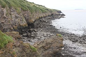
The rocks at Middle Hope are very old, from a time called the Carboniferous period. They show off unusual features, like a fossil cliff from the Pleistocene Ice Age. Because of these cool features, it's also a 'regionally important geological site'. The special rocks and soil here help rare plants grow. These include the smallflower buttercup, honewort, Cheddar pink, and Somerset hair grass. People have used this land for a very long time. There are ancient burial mounds from the Stone Age or Bronze Age. There's also the site of an old castle. Woodspring Priory, a historic monastery built in the 1200s, is just inland. The National Trust now owns the priory and the land around it. It's a popular spot for walks and exploring.
Amazing Geology
At Middle Hope, you can see layers of Carboniferous limestone. These rocks are very old, about 350 million years! They even include thick layers of volcanic ash and lava. This shows us what the area was like a very long time ago.
The site has a special fossil cliff and a flat shore platform. These were formed during the Pleistocene Ice Age. These features make Middle Hope a 'regionally important geological site' (RIGS). The flat areas were created by changes in sea level in the Bristol Channel over thousands of years. The way the volcanic and sedimentary rocks are arranged tells a story of events from 350 million years ago. The rock layers have been tilted and squeezed by huge forces during a mountain-building event called the Variscan orogeny.
Plants and Wildlife
Middle Hope is home to some rare plants. You can find the smallflower buttercup and honewort here. The different types of soil help many kinds of plants and animals to thrive.
The grassy areas have plants like Festuca species and Dactylis glomerata. Towards the west, you'll see bushes like hawthorn and blackthorn. To the east, there's common gorse and bramble. Even rarer plants grow here, such as the Cheddar pink and Somerset hair grass.
A Look Back in Time
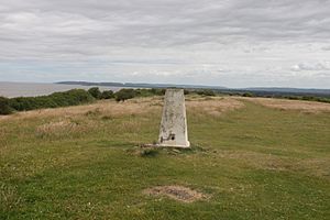
People have lived and used this land for a very long time. On the higher ground, you can find ancient burial mounds. These are called a bowl barrow and a disc barrow. They date back to the late Neolithic (Stone Age) or Bronze Age. The bowl barrow is about 10 meters wide and half a meter high. Just west of it is a disc barrow, which is a round area about 8 meters across, surrounded by a bank and ditch. These mounds are at the highest point of Sand Point. This is also where the Ordnance Survey built a triangulation station for mapping.
There might have been a motte-and-bailey castle built here after the Norman Conquest. This site is known as Castle Mound or Castle Batch. You can still see a mound about 2 meters high and 30 meters wide. It has a ditch on the land side. Sadly, the mound was damaged when a building was put there during World War II. Some people think the mound might have been a watchtower built in the 1500s, not a medieval castle. The stone walls of the sheep pens nearby were built by prisoners from the Napoleonic Wars. Hope Cove, on the northern coast, was once famous for smuggling. It was a good spot because it was far from the customs officers!
Woodspring Priory was a priory for Augustinian monks. It was started in the early 1200s by William de Courtney. The monks built a church and living areas over the next hundred years. They were known for working hard on their farm and being self-sufficient. They also provided priests for nearby churches. The priory wasn't very rich until the 1400s. Then, they built more, including the church you see today, an infirmary (hospital), and a barn.
The priory was closed down in 1536 during the Dissolution of the Monasteries. After that, it was owned by local noblemen and rented to farmers. In 1969, the Landmark Trust took over the priory. They spent 20 years restoring it. Since the 1990s, the farmhouse has been rented out for holidays. The buildings that are left include the priory church (from the 1400s), the infirmary, the barn, and the prior's lodging (from the 1500s), which became the farmhouse. The whole site was built around a central cloister (an open courtyard). Only parts of the east and west walls of the chapter house remain. Other parts like the sacristy, refectory, lady chapel, and parlour were taken down.
Because of its special plants, animals, and geology, Middle Hope was named a Site of Special Scientific Interest in 1952. In 1968, the National Trust bought the priory and the land around Middle Hope. This was part of their 'Project Neptune' to protect coastlines.
During World War II, weapons were tested at Sand Point. This was linked to a base at Birnbeck Pier, which was called "HMS Birnbeck." It was used by the Admiralty for researching new weapons. Buildings were put up at St Thomas Head, east of Middle Hope, to help with this. Some of these buildings have been removed. Today, the site is used by QinetiQ for testing explosives and shock.
 | Tommie Smith |
 | Simone Manuel |
 | Shani Davis |
 | Simone Biles |
 | Alice Coachman |


