Pen Cerrig-calch facts for kids
Quick facts for kids Pen Cerrig-calch |
|
|---|---|

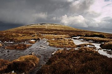
Pen Cerrig-calch from the col leading to Pen Allt-mawr
|
|
| Highest point | |
| Elevation | 701 m (2,300 ft) |
| Prominence | 52 m (171 ft) |
| Parent peak | Waun Fach |
| Listing | Hewitt, Nuttall |
| Naming | |
| English translation | top of the limestones |
| Language of name | Welsh |
| Geography | |
| Location | Black Mountains, Wales |
| OS grid | SO217223 |
| Topo map | OS Landranger 161 |
Pen Cerrig-calch is a mountain peak in the Black Mountains area of the Brecon Beacons National Park in southern Powys, Wales. It's like a smaller peak connected to the larger Waun Fach mountain.
The very top of Pen Cerrig-calch is 701 meters (2,300 feet) high. You'll find a special marker called a trig point there. This peak sits high above the River Usk valley, especially where the valley gets narrower near the town of Crickhowell. From the top, you can see amazing views that stretch far away, even to the main Beacons mountains in the west. A ridge, which is like a long, narrow hilltop, goes northwest from Pen Cerrig-calch. This ridge then turns north towards another peak called Pen Allt-mawr, which is 719 meters high and also has a trig point.
How Pen Cerrig-calch Was Formed: Geology Basics
Just like other hills in the Black Mountains, Pen Cerrig-calch is made from types of rock called mudstones and sandstones. These rocks are part of what geologists call the Old Red Sandstone. They were formed a very long time ago during a period known as the Devonian period.
What makes Pen Cerrig-calch special is that it also has a layer of Carboniferous Limestone rock near its top. This limestone can cause small holes in the ground called shakeholes. The name of the hill, "Pen Cerrig-calch," actually means 'top of the limestone rock' in Welsh, which tells us about its unique geology. The very top of the mountain is made of a different kind of rock, a pebbly sandstone from the Marros Group, which formed during the Carboniferous period.
The rounded southwestern side of the hill ends suddenly at a cliff called Darren. "Darren" means 'edge' in Welsh. This cliff was created by a huge landslip (a large amount of rock and soil sliding down a slope). This landslip likely happened after the last ice age. Many similar landslips can be found in the Black Mountains. They happen when weaker rock layers wear away, making the layers above them unstable. Below Darren, there's a big area of bumpy ground covered with large rocks from the Old Red Sandstone.
Ancient History: Archaeology on the Hill

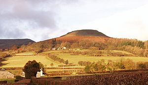
One of the most famous features on this hill is an old fort called Crug Hywel. This fort is believed to be from the Iron Age and sits on a tilted piece of rock on the southeastern side of the hill. It's also known as Table Mountain.
Besides the fort, there are also ancient stone piles called cairns on each of the main peaks. You can also find small, old quarries on the lower parts of the hill. These quarries were once used to dig out the Old Red Sandstone.
Exploring the Hill: Access and Paths
The higher parts of Pen Cerrig-calch are open for people to explore, thanks to laws that allow public access to certain lands. There are many footpaths that lead to this open access land. These paths come from the Usk Valley and from the valley of the Grwyne Fechan to the east.
A long-distance walking path called the Beacons Way goes around the southern and western sides of the hill. The most popular way to reach the summit of Pen Cerrig-calch is by following the path up the southeastern side, starting from Crug Hywel (Table Mountain).
 | Lonnie Johnson |
 | Granville Woods |
 | Lewis Howard Latimer |
 | James West |

