
Black Mountain (range) facts for kids

The Black Mountain (called Y Mynydd Du in Welsh) is a group of mountains in South, Mid, and West Wales. It sits right on the border between Carmarthenshire and Powys. This mountain range is the most western part of the Brecon Beacons National Park. Its highest point is Fan Brycheiniog, which stands tall at 802 metres (2,631 feet). The Black Mountain is also part of the Fforest Fawr Geopark, an area known for its important geological features.
Contents
What's in a Name?
It can be a bit confusing, but the Black Mountain is not the same as the Black Mountains. The other Black Mountains are found in the eastern part of the National Park. There's even a peak within those eastern Black Mountains that is also called Black Mountain!
Long ago, a historian named John Leland wrote about a "Blak Montayne." He was talking about a large area of mountains stretching from Carmarthen to Monmouth. This area is now known as the wider Brecon Beacons range, which includes both the Black Mountain and the Black Mountains.
Sometimes, people use the name "Carmarthen Fans" (or Bannau Sir Gâr in Welsh) to describe the whole Black Mountain area. However, this name should really only be used for the peaks along the northern edge within Carmarthenshire. For example, Fan Brycheiniog is actually just across the border in Brecknockshire. The "Carmarthen Fans" include peaks like Fan Foel, Picws Du, and Waun Lefrith. The highest point of the "Carmarthen Fans" and of Carmarthenshire county is Fan Foel, which is 781 metres (2,562 feet) high.
How Was the Black Mountain Formed?
The Black Mountain range stretches from Ammanford in the southwest to Sennybridge in the northeast. Most of these hills are made from a type of rock called Old Red Sandstone. However, other types of rock, like Carboniferous Limestone and Twrch Sandstone, are also important. These rocks are stronger and resist erosion (wearing away) more, which helps shape the landscape. The strongest rocks, called Plateau beds, cover most of the range like a protective cap. They also form steep cliffs just below the mountain edges.
All these rocks formed during the Devonian period, just like the rocks in the Brecon Beacons to the east. The area was covered by huge sheets of ice, called glaciers, during the ice ages. As the glaciers moved, they carved out valleys and left behind piles of rock and dirt called moraines. You can still see these moraines below the amazing sandstone cliffs on the north and east sides of the range, especially near Fan Hir. Smaller moraines are also found below the cliffs of Waun Lefrith and Picws Du.

The two main lakes, Llyn y Fan Fawr and Llyn y Fan Fach, are also leftovers from the glaciers. They formed in deep hollows carved by the ice, and moraines blocked the water, creating the lakes.
Ancient Discoveries in the Black Mountain
The Black Mountain area is full of ancient remains, especially from prehistoric times and the Roman era. You can find old Roman forts, called castra, at Mynydd Bach Trecastell. There's also a Roman road called Sarn Helen that crosses Fforest Fawr.
Many menhirs (tall standing stones), round barrows (ancient burial mounds), and small stone circles are scattered around. A very famous stone circle, known as Cerrig Duon (or "black stones"), is found near the River Tawe below Fan Hir. Close by, there's a large standing stone called Maen Mawr, with two smaller stones forming a little path.
Archaeologists have also found signs of human settlements, including hut circles and evidence of agriculture (farming). A recent dig at a cairn (a pile of stones) or round barrow on Fan Foel showed it was from the early Bronze Age, around 2000 BC. There's a similar, untouched burial mound on Picws Du. The dig at Fan Foel suggested that during the Bronze Age, the moorland was covered in trees, like hazel bushes and oak trees at lower levels, because the climate was warmer than it is today. Many other moorlands in Britain were also wooded back then.
Rivers and Lakes of the Black Mountain
The Black Mountain is drained by several rivers that flow down its southern slopes. The streams flowing north tend to be shorter and steeper. The higher parts of the range are mostly moorland covered with peat bogs. Some of these peat bogs are slowly breaking down, as seen by damaged sections near Llyn y Fan Fawr.
The Usk and Tawe rivers start on the northern and eastern sides of the range. The smaller Loughor begins at the western end. Important rivers flowing south include the River Giedd and the Afon Twrch (which join the Tawe), and the River Amman (which joins the Loughor). Two rivers that flow into the River Towy, the River Cennen and the Afon Sawdde, drain the northwestern slopes of the Black Mountain.
The range is famous for its two large glacial lakes, which sit right below the main cliffs. These lakes are much bigger than the small lake found below Pen y Fan.
Llyn y Fan Fach
.jpg)
Llyn y Fan Fach (Welsh for 'lake of the small peak') is the smaller and more western of the two natural lakes in the Black Mountain. It sits in a hollow carved out by glaciers during the ice ages. The lake is about 500 yards long and 200 yards wide, running roughly east to west. It's drained by the Afon Sawdde river, which cuts through a glacial moraine that acts like a natural dam. In the 1930s, a small artificial dam was built to send some of its water to help supply Llanelli. Llyn y Fan Fach is also famous for the Lady of the Lake legend.
You can easily walk to the lake from a car park near Llanddeusant. However, the road to the car park isn't well marked and can be quite rough for cars.
Llyn y Fan Fawr
Llyn y Fan Fawr (Welsh for 'lake of the large peak') is located below Fan Brycheiniog towards the eastern end of the mountain. It was also formed by glaciers, similar to its western neighbor, but it's slightly larger. It's about 600 yards long and 200 yards wide, running roughly north to south. A stream called Nant y Llyn (Welsh for 'stream of the lake') drains the lake, and its waters flow into the River Tawe. The surface of Llyn y Fan Fawr is about 605 metres (1980 feet) above sea level.
You can reach this lake by walking about 1.7 miles (2.7 km) across the moor from the minor road between Trecastle and Abercraf. There's a small parking area there. Another small car park is a short distance away on the same road, at the start of another path to the lake.
Exploring the Black Mountain
Some parts of the Black Mountain are more than 5 kilometres (3 miles) from the nearest public road. These roads are usually very small, single track roads with only a few places to pass other cars, making the center of the range quite remote. There are several small car parks on the minor roads that cross the range. A larger car park is found on the road from Llanddeusant village, leading to the path for Llyn y Fan Fach.
Almost the entire Black Mountain area is considered "open country." This means that people can legally walk there under the rules of the Countryside and Rights of Way Act 2000.
The range also has several long bridleways that cross it from north to south. These paths can be used by mountain bikers and horse riders, although many sections are very rough and hard to follow. The Beacons Way long-distance path also crosses the range from east to west. Because more people are using some paths, they have started to wear away faster. This problem is made worse by the thin, gravelly soil and high rainfall. The Brecon Beacons National Park Authority has been working to repair these paths. There are many peat bogs on the higher and middle ground, but some are covered with stone paths to help walkers cross. There's a well-built stone staircase that takes the Beacons Way path from Llyn y Fan Fawr up the steep slope to Fan Brycheiniog in the middle of the range.
Amazing Wildlife
.jpg)
The Black Mountain is home to many different kinds of birds. You might spot a red kite, a common buzzard, a kestrel, a carrion crow, a common raven, or a skylark. The red kite used to only live in this area and nearby parts of South Wales, like Mynydd Mallaen, because they were hunted in other parts of the country. But now, they have been brought back to many areas in southern Britain, such as the Chilterns. Kestrels and buzzards are common everywhere, but ravens usually stick to the higher mountains.
You'll also find many mammals like field voles, red foxes, and badgers, as well as lots of songbirds. Skylarks are very common because there are large areas of rough grassland below the main peaks, which is where they like to build their nests on the ground. Pied wagtails are often seen near the streams and fast-flowing water coming down from the hilltops.
Legends and Stories
The Black Mountain is known as one of the wildest places in Wales. It's connected to many old myths and legends, like the famous Arthurian story of the Lady of the Lake and the tale of Twrch Trwyth. More recent events are also remembered in stories and poems, such as 'From the Mist to Heaven,' written after a sad event on these moors in May 1904. Cribarth, on the southeastern edge of the Black Mountain, is sometimes called the Sleeping Giant by local people. This is because its shape, when seen from Cwm Tawe to the south, looks like a giant lying down.
Images for kids
-
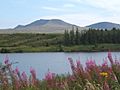
The Black Mountain range seen from the Usk Reservoir.

