Afon Twrch facts for kids
Quick facts for kids Afon Twrch |
|
|---|---|

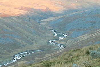
Afon Twrch looking south downstream from the side of Pen yr Helyg
|
|
| Country | Wales |
| Physical characteristics | |
| Main source | Southern slopes of Bannau Sir Gaer (Carmarthen Fans) and Fan Brycheiniog 770 metres (2,530 ft) 51°52′49″N 3°42′39″W / 51.880359°N 3.710933°W |
| River mouth | River Tawe at Ystalyfera 70 metres (230 ft) 51°45′40″N 3°46′55″W / 51.761194°N 3.782022°W |
| Length | 8.7 miles (14 km) |
| Basin features | |
| River system | River Tawe |
| Tributaries |
|
The Afon Twrch is a river in south Wales. It starts high up in the Black Mountain range. This river forms a natural border between different areas. For example, it separates the counties of Brecknockshire and Carmarthenshire. Further downstream, it also separates Brecknockshire from Glamorgan.
Contents
What's in a Name?
The name Afon Twrch comes from the Welsh language. Afon means 'river'. Twrch means 'boar', which is a type of wild pig. People think the name might describe how the river's water moves. It could be like a boar digging or snouting through the land. There's also an old Welsh legend about a magical boar called Twrch Trwyth. This river is sometimes linked to that famous story.
Where Does the River Flow?
The Afon Twrch begins on the southern slopes of two mountains. These are Bannau Sir Gaer (also known as the Carmarthen Fans) and Fan Brycheiniog. Soon after it starts, another small river, the Twrch Fechan, joins it. The river then flows generally south for about 14 kilometers (or 9 miles). It eventually meets and joins the River Tawe in a place called Ystalyfera.
- Some important smaller rivers that join the Afon Twrch are the Nant Gwys and the Nant Llynfell.
Towns and Villages Along the River
Several towns and villages are located along the lower part of the Afon Twrch. These include:
- Ystradowen
- Cwm-twrch-uchaf
- Cwm-twrch-isaf
- Gurnos
Old Industrial Sites
Long ago, there was a coal mine at Henllys Vale. From this mine, special tracks called tramroads ran down the valley. These tracks were used to move coal to Cwm-twrch-isaf. Today, you can still see some parts of the old mine. A tall brick chimney is one of the most impressive remains. There are also old limekilns, which were used to make lime. You can reach these old sites by walking along the path where the tramway used to be. This path starts from Brynhenllys Bridge.
Special Nature Area
Parts of the Cwm Twrch area are very special. They are called a SSSI. This means they are protected because they show a great example of how different layers of rock meet. It's like looking at a geological puzzle!
 | Jackie Robinson |
 | Jack Johnson |
 | Althea Gibson |
 | Arthur Ashe |
 | Muhammad Ali |

