
Glamorgan facts for kids
| Glamorgan | |
| Motto: A ddioddefws a orfu (lit. He who suffered, conquered) | |
 Flag adopted in 2013 |
|

Show location in Wales 
Show location in England and Wales 
Show location in the United Kingdom |
|
| Geography | |
| 1861 area | 547,494 acres (2,215.63 km2) |
| 1911 area | 518,865 acres (2,099.77 km2) |
| 1961 area | 523,253 acres (2,117.53 km2) |
| HQ | Cardiff |
| Chapman code | GLA |
| History | |
| Succeeded by | |
Quick facts for kids Demography |
|
|---|---|
| 1861 population - 1861 density |
326,254 0.7/acre |
| 1911 population - 1911 density |
1,120,910 2.2/acre |
| 1961 population - 1961 density |
1,229,728 2.4/acre |
| Politics | |
| Governance | Glamorgan County Council (1889–1974) |
 |
|
Glamorgan (pronounced gluh-MOR-gun), also known as Glamorganshire, was a very important area in the south of Wales. Until 1974, it was an official county. It was one of the thirteen historic counties of Wales.
Long ago, Glamorgan was a small kingdom called Morgannwg. It was often a place where Welsh princes and Norman lords fought. You could tell by the many castles built there! After England took control in the 1500s, Glamorgan became more peaceful. It then used its natural resources to become a key part of the Industrial Revolution.
Glamorgan was the most populated and industrial county in Wales. It was even called the "crucible of the Industrial Revolution." This is because it had huge amounts of coal and was a world leader in making iron, steel, and copper.
In 1974, Glamorgan was divided into three new counties: West Glamorgan, Mid Glamorgan, and South Glamorgan. The name Glamorgan still lives on in the Vale of Glamorgan, which is a county today.
Glamorgan had different types of land. There were busy industrial valleys, peaceful farming areas, and the beautiful Gower Peninsula. It shared borders with Brecknockshire to the north, Monmouthshire to the east, and Carmarthenshire to the west. To the south, it met the Bristol Channel. The county had two major cities: Cardiff, which became the capital of Wales in 1955, and Swansea.
Contents
- History of Glamorgan
- Geography of Glamorgan
- How Glamorgan Was Governed
- Travel and Transport in Glamorgan
- Culture and Fun in Glamorgan
- Images for kids
- See also
History of Glamorgan
Ancient Times: Early Humans in Glamorgan

People have lived in Glamorgan for over 200,000 years! The climate changed a lot, with glaciers coming and going. This caused sea levels to rise and fall. Sometimes, the area was full of life. Other times, it was too cold to live there.
Scientists have found signs of Neanderthals on the Gower Peninsula. We don't know if they stayed during the coldest times. The sea level was once 150 meters lower and 8 meters higher than it is now. This changed the coastline a lot over time.
Evidence shows that humans settled here during warmer periods. The oldest known human burial in Great Britain was found in a cave on the Gower Peninsula. This person, called the Red Lady of Paviland, lived about 29,000 years ago. Back then, the cave looked out over a flat plain, far from the sea.
After the last ice age (about 10,000 to 12,000 years ago), Mesolithic hunter-gatherers came to Britain from Europe. They mostly settled on the coastal plains. The higher lands were used by special hunting groups.

Around 6,000 years ago, people in Europe changed their way of life. They stopped being nomadic hunters and gatherers. Instead, they started farming and settling down. They cleared forests for fields and raised animals. They also learned new skills like making pottery and weaving.
During this time, people built large stone tombs called dolmens or cromlechi. These were built between 6,000 and 5,000 years ago. This was about 1,500 years before Stonehenge or the Great Pyramid of Giza were finished! Nineteen of these tombs have been found in Glamorgan. Building them would have needed many people, suggesting large communities lived nearby.
The Bronze Age brought new changes, like using metal. Over 600 Bronze Age burial mounds have been found in Glamorgan. People also invented the wheel, learned to weave, and made beautiful metal items like jewelry. Forests continued to be cleared as the climate got warmer, allowing farming even in higher areas.
Around 4,000 years ago, people started burying their dead in individual stone boxes under round mounds. From about 3,350 years ago, the climate got worse, making farming hard in the uplands. This led to more conflict. People started building hill forts in the Late Bronze Age and throughout the British Iron Age. Weapons also became better and more common.
Before the Roman conquest of Britain, Glamorgan was part of the land of the Silures. This was a Celtic British tribe known for their hill forts. Even the Roman fort in Cardiff, built in 75 AD, was placed over a large settlement of the Silures.
Morgannwg: A Welsh Kingdom
|
Kingdom of Morgannwg
Teyrnas Morgannwg
|
|||||||||||||||
|---|---|---|---|---|---|---|---|---|---|---|---|---|---|---|---|
| 942-974 1063-1091 |
|||||||||||||||
| Capital | Various | ||||||||||||||
| Common languages | Welsh | ||||||||||||||
| Government | Monarchy | ||||||||||||||
|
• 942 - 974
|
Morgan Hen ab Owain | ||||||||||||||
|
• 1063 - 1074
|
Cadwgan ap Meurig | ||||||||||||||
|
• 1081 - 1091
|
Iestyn ap Gwrgan | ||||||||||||||
| Historical era | Middle Ages | ||||||||||||||
|
• First union of Gwent and Glywysing
|
942 | ||||||||||||||
|
• Union disestablished
|
974 | ||||||||||||||
|
• Kingdoms reunited
|
1063 | ||||||||||||||
|
• Conquered
(by the Norman lord, Robert Fitzhamon) |
1091 | ||||||||||||||
|
|||||||||||||||
The region started as a small kingdom called Glywysing. It was likely named after a Welsh king from the 5th century, Glywys. The name Morgannwg or Glamorgan means 'territory of Morgan'. It probably came from an 8th-century king named Morgan ab Athrwys. He united Glywysing with other kingdoms.
Because of its location, Morgannwg was one of the first parts of Wales to be taken over by the Normans. It was often a battleground between the Norman lords and Welsh princes.
The earliest important buildings were earth walls and simple defenses on hillsides. Most of these were later built over with stronger stone castles. Some of the oldest surviving stone markers are from the 5th to 7th centuries. One of the best preserved is the 9th-century 'Houelt' stone at Llantwit Major.
Norman Control: The Lordship of Glamorgan
The Lordship of Glamorgan was created around the 1080s. This happened after Robert Fitzhamon defeated the Welsh ruler Iestyn ap Gwrgant. The kingdom of Morgannwg was split up. The main part, with Cardiff as its center, stretched from the River Tawe to the River Rhymney. The Gower Peninsula was not part of this lordship.
The Normans built many castles in Glamorgan. Many of these castles are still standing today, though some are in ruins. Famous ones include Caerphilly Castle, Cardiff Castle, Ogmore Castle, and St Donat's Castle. During the Welsh Revolt (1400–1415), many of these castles were attacked. Some were captured and damaged so badly they were never used for defense again.
The Diocese of Llandaff (a church area) became part of the Province of Canterbury. The Bishop of Llandaff started rebuilding the small church into Llandaff Cathedral in 1120. Monasteries were also built, like Neath Abbey and Margam Abbey. Parish churches began to appear in the 12th century, especially in the Vale of Glamorgan.
Becoming a County: Glamorgan from 1536
In 1536, the Laws in Wales Acts 1535 and 1542 officially made Glamorgan a county. This joined the Lordship of Glamorgan with the areas of Gower and Kilvey. Wales was now fully part of England. The King's judges took over the legal system. Glamorgan also got its first representatives in Parliament.
The English Reformation and the closing of monasteries led to big social changes. Wealthy Welsh families gained power and land. They turned old monasteries into grand country houses. Important families included the Carnes, Mansels, and Stradlings. They preferred living in comfortable homes rather than old castles.
Farming was the main industry in Glamorgan during this time. In the hilly Blaenau area, people raised horses, cattle, and sheep. In the lower Bro area, they grew crops and raised more general livestock. Other industries were small, like shallow coal pits, weaving, and pottery. Copper smelting was important, especially around Swansea and Neath. Swansea became Britain's copper smelting capital in the early 1700s.
Iron smelting was also present but on a small scale. By 1740, Glamorgan only produced about 400 tons of iron a year.
Glamorgan was also involved in England's conflicts. During the First English Civil War, Glamorgan sent troops to support King Charles I of England. The Second English Civil War saw the Battle of St Fagans in Glamorgan in 1648. Here, the Parliamentarian army defeated the Royalists.
Architecturally, this period saw wealthy families build grand homes to show their status. However, from 1650 to 1750, fewer grand buildings were constructed. Many old castles were abandoned because the county was now protected by the Crown. Only the Stradlings of St Donat's Castle continued to live in their ancestral home.
By the 1600s, good building stone was available. This allowed for the construction of nice lime-washed cottages and farmhouses in the Vale of Glamorgan. People living there often had more comfortable homes than those in other parts of Wales.
Industrial Glamorgan: A Time of Growth (1750–1920)

From the mid-1700s, Glamorgan's uplands became very industrial. Coastal towns like Swansea and Cardiff grew into major ports. For many years, Glamorgan produced 70% of Britain's copper. This industry was mostly in the west of the county, where coal was cheap and copper ores could be imported. By 1823, the copper works in Swansea supported 8,000 to 10,000 people. However, by the 1920s, the copper trade ended due to shipping costs and foreign competition. Some works switched to making zinc and nickel.
Iron smelting was even more important than copper. It grew in areas where ironstone, coal, and limestone were found together. In the late 1700s, four major ironworks were built in Merthyr Tydfil. These were Dowlais Ironworks, Plymouth Ironworks, Cyfarthfa Ironworks, and Penydarren Ironworks. Merthyr Tydfil became the main center for ironmaking in Wales.
Glamorgan also became a key place for making tinplate. It was known as the "crucible of the Industrial Revolution" because of its huge role in these metal industries. Other industries, like the Brown Lenox Chainworks in Pontypridd, used the metals produced.
Coal Mining Boom
The biggest change came from opening up the South Wales coalfield. This huge coalfield covered most of Glamorgan. Before 1750, coal was dug from shallow pits or exposed seams. But soon, coal was needed for the growing metal industries. By 1828, the South Wales coalfield produced 3 million tons of coal. By 1840, it was 4.5 million tons.

The 1840s saw a huge increase in coal mining. This was helped by the discovery of steam coal in the Cynon Valley, the building of a large dock in Cardiff, and the Taff Vale Railway. In 1845, Welsh steam coal became the preferred fuel for the Royal Navy. This made Glamorgan coal very popular worldwide.
The Rhondda Valleys had the richest steam coal. By 1856, the Taff Vale Railway reached the Rhondda. Over the next 50 years, the Rhondda became the biggest coal producer. In the 1890s, the docks of South Wales handled 38% of British coal exports.
This growth in coal production led to a massive increase in population. People moved to Glamorgan for work. For example, Aberdare's population grew from 6,471 in 1841 to 32,299 in 1851. The Rhondda grew from 3,035 in 1861 to 55,632 in 1881. Many people came from England.
Farming in Industrial Times
Before the 1700s, Glamorgan was mostly about farming. But with industrialization, farming became less important. Industrial areas took over farmland. From the late 1800s, Glamorgan shifted from growing crops to raising animals. This was because the growing population needed more milk and dairy. Also, industrial jobs paid better, so fewer people wanted to work on farms. Raising cattle and sheep became common.
Buildings of the Industrial Age
The industrial period saw a huge building boom. Many new, affordable homes were needed for the hundreds of thousands of workers. Towns grew rapidly. New buildings included factories, miners' cottages, railway stations, hospitals, churches, schools, and museums.
Some wealthy industrialists built grand homes in the Gothic style, like Cyfarthfa Castle in Merthyr. Public buildings often used Greek Revival architecture, like the Royal Institution of South Wales in Swansea. Cathays Park in Cardiff was developed into a beautiful civic center with buildings like the City Hall.
Most Nonconformist chapels were built in the 1800s. They started simple but became larger and more detailed. The Morriston Tabernacle (1872) was especially grand, called the 'Nonconformist Cathedral of Wales'. Industrial buildings were usually practical, but some, like the engine house at Cyfarthfa Ironworks, were built to impress. Tall winding towers at coal mines became symbols of the industry.
Later Years: Glamorgan (1920–1974)
After World War I, coal and iron production dropped. Unemployment in the valleys rose sharply. Many things caused this, including changes in currency value and the growth of electric power. By the 1930s, the South Wales Coalfield had low productivity and high costs.
The 1926 United Kingdom general strike and the Great Depression (1929–1931) changed industrial Glamorgan forever. In 1932, over 40% of people in Glamorgan were unemployed. For example, in Merthyr, unemployment was below 2% in 1913. By 1934, it was 8,000. Steel production also suffered. Old works closed, and steelmaking moved to the coast.
Glamorgan was hit hard because most of its workers were in primary industries like mining. Other parts of Britain recovered faster. However, the coastal ports of Cardiff and Swansea kept a "reasonable" level of economic activity.
During World War II, coal production and employment rose again. But many young men joined the war effort, leading to a worker shortage in the mines. This led to the Bevin Boys, who were conscripted to work in the mines. Cardiff and Swansea were bombed because of their important docks.
Buildings of the Later Period
After World War I, buildings in Glamorgan became more focused on function than on grand design. Old industrial buildings were torn down and replaced with simpler, geometric factories. Concrete became popular after the war, leading to large office blocks in cities.
Some notable buildings from this time include The National Museum of Wales, completed in 1927. It has a dome and Doric columns. Percy Thomas' Guildhall (1936) was called "Wales' finest interwar building."

Sully Hospital (1936) was built for patients needing lots of light and air. Its functional design resulted in a striking glass-fronted building. The University Hospital of Wales, completed in 1971, is one of the largest hospitals in the UK. It was designed to combine patient care, research, and teaching.
New housing estates grew, moving away from the old Victorian terraces. Some of these projects, like the Billybanks estate in Penarth and Penrhys Estate in the Rhondda, were not very successful.
Geography of Glamorgan

Glamorgan has three main geographical areas:
- The South East: This area is a gently rolling limestone plateau, mostly farmland and small villages. It's great for farming. Major towns here included Cardiff, Barry, Bridgend, and Penarth.
- The North: This is a mountainous area with deep, narrow valleys. It's part of the South Wales coalfield. In the 1800s, this area saw huge growth in industry and population. Towns like Aberdare, Caerphilly, Pontypridd, and Merthyr Tydfil grew here. The last deep coal mine, Tower Colliery, closed in 2008.
- The West: This includes Swansea Bay and the beautiful Gower Peninsula, which is an Area of Outstanding Natural Beauty. Gower was less affected by heavy industry. It has wild common land, beaches, and rocky coastlines. Major settlements here include Swansea, Neath, and Port Talbot.
Glamorgan's Coastline
Glamorgan's coastline stretches for 88 miles. It has three distinct parts:
- Vale of Glamorgan Coast: Mostly cliffs, from Porthcawl to Cardiff.
- Central Coast: Wide sandy shores from Porthcawl to Swansea Bay.
- Gower Coast: A rugged and jagged peninsula.
Starting from the east, the Rhymney River was once the border with Monmouthshire. Further west, the River Taff flows into Cardiff Docks. This area was once marshland but became a huge port during the Industrial Revolution. The docks declined when the coal and iron industries slowed down. Penarth is a seaside resort near Cardiff. Flat Holm, an island in the Bristol Channel, is the southernmost point of Glamorgan and Wales.

Moving west, you reach Barry, a popular seaside resort. Barry grew quickly in the late 1800s to become a major dock, even surpassing Cardiff for coal exports at one point. The coastline then becomes low-lying, passing villages like Rhoose and Aberthaw. Breaksea Point is the southernmost point of mainland Wales.
The cliffs rise again for eleven miles, passing Llantwit Major and St Donats. After Dunraven Head, the cliffs drop to reveal Southerndown Beach. The River Ogmore flows into a sandy bay, marking the start of the second section of the coast. This area has huge sand dunes, known as the Merthyr Mawr sand dunes.

Porthcawl is a town here, which shifted from a small dock to a tourist destination. The sandy coastline continues to Port Talbot, an industrial town that grew from the medieval village of Aberavon. Port Talbot Steelworks is a major feature here.
The River Afan starts the wide curve of Swansea Bay. This bay includes Baglan Bay, Briton Ferry, Swansea, and ends at Mumbles. The bay is surrounded by hills and has thick sands. Two major rivers, the River Neath and the River Tawe, flow into the bay. Mumbles Head is the westernmost point, with Mumbles Lighthouse on a small island.

At The Mumbles, the coastline becomes wild and rugged cliffs of the Gower. From Mumbles Head to Worm's Head, the coast has steep cliffs and sandy bays. Famous bays include Langland Bay, Caswell Bay, and Three Cliffs Bay. Three Cliffs Bay and Oxwich Bay are overlooked by old castles like Pennard Castle and Oxwich Castle.
.jpg)
Worm's Head is a striking feature, a long, narrow limestone ridge sticking into the sea. It looks like a dragon! On its northern side is Rhossili Bay, a beautiful sandy bay. The coastline then turns north-east, forming the Burry Inlet, a shallow estuary leading to salt marshes. The River Loughor forms the border between Glamorgan and Carmarthenshire.
Rivers of Glamorgan
The main rivers in Glamorgan are the River Taff, River Ely, River Ogmore, River Neath, River Dulais, River Tawe, Rhymney River (which was the historic border with Monmouthshire), and the River Loughor (which was the historic border with Carmarthenshire).
How Glamorgan Was Governed
After the Welsh kingdom of Morgannwg fell to Robert FitzHamon in 1091, the region became the English Lordship of Glamorgan. It was split into a Norman-controlled plain (the Vale of Glamorgan) and a Welsh upland area called Morgannwg. Both were ruled by the Norman Lords of Glamorgan. The Normans also reorganized the church, making Llandaff Cathedral the center of the diocese.
In 1536, the Laws in Wales Acts 1535–1542 created the historic county of Glamorgan. It gained representatives in Parliament. Judges from England came to administer law. Local magistrates handled smaller cases. The High Sheriff of Glamorgan was in charge of law enforcement.
Over time, people called for fairer representation in Parliament. The Reform Act 1832 gave Glamorgan more Members of Parliament (MPs). By 1885, all ten of Glamorgan's seats were won by the Liberal Party. This showed the growing power of the nonconformist middle classes. However, by 1922, the county was represented by eleven Labour MPs, showing a big shift in politics.
An administrative county of Glamorgan was created in 1888, but Swansea and Cardiff became independent county boroughs. Later, Merthyr Tydfil also became a county borough.
Glamorgan County Council's coat of arms, granted in 1950, had red chevronels on a gold shield (from the De Clare lords) and Tudor roses (for Henry VIII). The crest had a Welsh dragon rising from flames, symbolizing the county's industrial revival. The supporters were a coal miner and a steel worker. The motto, A Ddioddefws A Orfu ('He Who suffered, conquered'), reflected the hardship and success of the area.
In 1974, Glamorgan was abolished and split into West Glamorgan, Mid Glamorgan, and South Glamorgan. In 1996, these areas were further reorganized into smaller local authorities. The South Wales Police force still covers an area similar to old Glamorgan. Since 2013, Glamorgan has its own official flag, which is red with three white chevrons.
Travel and Transport in Glamorgan
Roads and Highways
The earliest ways to travel in Glamorgan were just paths between settlements. Over time, these paths widened into basic roads. The Romans built a road, Via Julia Maritima, which much of the modern A48 follows. For 1,000 years after the Romans, there wasn't much need for major roads. Roads were poorly maintained.
In 1756, Wales started using a toll system to maintain roads. People had to pay a fee to use certain roads. This system improved travel, allowing for stagecoaches. However, some people thought the tolls were unfair. Between 1839 and 1843, there were protests called the Rebecca Riots, where people attacked toll houses. While most attacks were in Carmarthenshire, some happened in Swansea.
The toll system was eventually abolished in 1888. Roads then came under the control of local county councils.
In the 1930s, plans for a new high-quality road across South Wales began. The A48 Neath bypass was finished in 1960. The A48(M) Port Talbot bypass opened in 1966. This was the first motorway section in Wales. The M4 motorway was later extended all the way to Carmarthenshire. The A465 Heads of the Valleys road opened in 1964.
Waterways and Ports
Glamorgan's long coastline meant many towns grew as harbors and ports. In 1801, Swansea was Glamorgan's largest town. Cardiff became important for exporting iron from Merthyr. Roads were built, but moving goods by horse was slow.
So, canals were built. Between 1790 and 1794, three canals were approved: the Glamorganshire Canal, Neath Canal, and Swansea Canal. These canals were vital for moving iron, copper, steel, and coal from the uplands to the ports. They changed commercial transport in Glamorgan. However, in 1804, Richard Trevithick's "Pen-y-Darren" locomotive became the first engine to pull a load on rails. This marked the start of railways, which would eventually replace canals.

The port at Cardiff grew rapidly in the 1800s, mainly for exporting coal. By 1871, Cardiff was the most populated town in Wales. Swansea Docks remained a top copper exporter but didn't grow as much as Cardiff.
The biggest challenge to Cardiff's dominance came from Barry. In 1881, Barry had only 484 people. But after a railway and docks were approved in 1884, it grew to over 27,000 by 1901. By 1901, Barry was exporting more coal than Cardiff.
The Great Depression ended the prosperity of Glamorgan's ports. During World War II, the ports were bombed, but exports continued. By the late 1900s, most docks declined. Cardiff and Barry Docks became almost empty as the coal trade collapsed. Swansea also saw a huge drop in trade. Only the Port of Port Talbot remained a major exporter, especially after the Abbey Works were built in 1952. Port Talbot became the biggest exporting port in Glamorgan.
Railways
Before locomotives, railway tracks were used with canals to connect places. Horses pulled wagons on wooden, then iron, rails. The first railway network in Glamorgan, the Taff Vale Railway, was also the first in Wales. It linked the ironworks of Merthyr to Cardiff's ports. It opened in 1840 and carried both goods and passengers. By 1856, it reached the Rhondda Valleys, allowing coal mining to boom there.
The South Wales Railway opened later, connecting Gloucester to Neyland. It linked Glamorgan's coalfields to London. Other railways like the Vale of Neath Railway and Rhymney Railway also opened. Their main purpose was to transport metals and coal to the growing ports.
In 1888, the Barry Railway Company was formed to create a new export port at Barry Docks. This challenged the Taff Vale Railway's control. The plans were heavily debated in Parliament. Another important event was the Taff Vale Railway Strike of 1900. A court ruling said that trade unions could be held responsible for financial losses caused by strikes. This decision was a key reason for the creation of the British Labour Party.
In the 1900s, railway use slowly dropped as industries and mines closed. After World War II, railways were nationalized in 1948. In the 1960s, many passenger lines were closed.
Airports
Glamorgan had several airports. Cardiff Airport was the main one. It started as a military air station in 1942. It was first called Rhoose Airport, then Glamorgan, Rhoose Airport, and later Cardiff-Wales Airport.
Swansea Airport also started as an RAF station before opening for commercial use in 1956. Regular flights stopped in 1969. The worst aviation disaster in Wales happened in Glamorgan in 1950. A plane crashed at Llandow Aerodrome, killing many people.
Culture and Fun in Glamorgan
Sports in Glamorgan
Sports were a big part of life in Glamorgan. The county produced many famous athletes and teams. One of the first recorded team sports in Wales was bando, similar to bandy. It was very popular before rugby football took over.
The most famous team named Glamorgan is Glamorgan County Cricket Club. Cricket started in Cardiff in 1819. The county team formed in 1888 and gained first-class status in 1921. They still play as Glamorgan today.

Baseball was also very popular in Cardiff, especially in the 1930s.
Rugby union was one of the most popular sports. Glamorgan had some of the oldest rugby clubs in the world, like Swansea RFC, Cardiff RFC, and Merthyr RFC. These clubs helped start the Welsh Rugby Union in 1881. Famous stadiums like St. Helen's Rugby and Cricket Ground (Swansea) and Cardiff Arms Park hosted international rugby games. Glamorgan also had its own invitational rugby team, Glamorgan County RFC, which played against teams like the All Blacks.
Association football (soccer) was also very popular. Glamorgan produced two teams with long histories: Swansea City (formed 1912) and Cardiff City (formed 1899). Both played in the English football league system. Cardiff City was very successful, winning the FA Cup in 1927.
Boxing was perhaps Glamorgan's most successful individual sport. Many world-class boxers came from the northern coalfields and Cardiff. Famous boxers include Jimmy Wilde (World Flyweight Champion) from Rhondda, Freddie Welsh (World Lightweight Champion) from Pontypridd, and 'Peerless' Jim Driscoll (British Featherweight Champion) from Cardiff.
Tourism in Glamorgan
Glamorgan and Wales didn't become popular tourist spots until the late 1700s. Before that, wealthy English gentlemen preferred to travel in Europe. But after conflicts there, they looked for "wild" places in their own country. These early tourists wrote and painted about what they saw.
The Industrial Revolution created a new middle class and better transport. This led to a growing tourist trade. In the late 1800s, with better rail links, coastal areas like Barry Island, Porthcawl, and Mumbles grew as tourist destinations. These towns became popular because of the coal industry and workers' annual holidays. By the mid-1900s, they added caravan parks and chalets to host more visitors.
As the 20th century went on, people had more free time. Glamorgan responded by creating county parks, museums, art galleries, and activity centers.
Images for kids
-
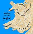
Tribes of Wales at the time of the Roman invasion
-
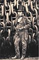
Isambard Kingdom Brunel with chains made by Brown Lenox of Pontypridd
-
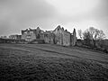
Beaupre Castle


See also
 In Spanish: Glamorganshire para niños
