
Controlled-access highway facts for kids


_(filtered).jpg)
A controlled-access highway is a special type of highway built for fast car and truck traffic. These roads are designed so that all traffic entering or leaving is carefully controlled. You might know them by other names like freeway, motorway, or expressway.
On these highways, traffic flows smoothly without stopping. There are no traffic signals, intersections, or direct access to nearby buildings. Instead, other roads, railways, or paths go over or under the highway using overpasses and underpasses. Cars get on and off the highway using special ramps called interchanges. These ramps help cars change speed safely. Traffic going in opposite directions is usually separated by a median strip or a barrier. This design makes these roads much safer and helps traffic move faster.
Controlled-access highways started to appear in the early 1900s. Italy was the first country to build them in 1924. Germany followed in 1932 with its first autobahn. In North America, the first freeways (called parkways) opened in the New York City area in the 1920s. Today, many advanced countries have huge networks of these highways. They help people travel quickly between cities and within large urban areas.
What Makes a Highway "Controlled-Access"?


Different countries have slightly different rules for what makes a road a "motorway" or "freeway." However, there are some common ideas:
- No Direct Access: These roads don't have driveways leading directly to homes or businesses.
- No Crossings at the Same Level: Cars, trains, or people never cross the highway at the same height. They always go over or under.
- Special Signs: There are specific signs to show you are entering or leaving a controlled-access highway.
- Restricted Vehicles: Usually, only motor vehicles (cars, trucks, buses) are allowed. Pedestrians, bicycles, and slow-moving vehicles are often not permitted.
These features help keep traffic moving fast and safely.
How These Highways Began


Modern controlled-access highways started in the 1920s. This was because more and more people were using cars, and they needed faster ways to travel between cities.
- Italy's First Autostrada: The very first controlled-access highway was the Autostrada dei Laghi in Italy. It opened in 1924 and connected Milan to Lake Como and Lake Maggiore. This early highway had one lane in each direction and no interchanges.
- Germany's Autobahn: Germany began building its famous Autobahn system in 1929. The first section opened in 1932 between Cologne and Bonn. Germany quickly built the first nationwide network of these roads.
- North American Parkways: In North America, early versions were called "parkways." The Bronx River Parkway in New York was the first road to use a median strip to separate traffic.
- Canada's Queen Elizabeth Way: Canada's first highway with some controlled access was The Middle Road, which became the Queen Elizabeth Way. It opened in 1937 and had special interchanges.
The word "freeway" was first used in 1930 by Edward M. Bassett. He said freeways were public roads for movement, where nearby property owners didn't have direct access.
Designing Controlled-Access Highways


Controlled-access highways are built to keep traffic moving smoothly and safely.
- No Traffic Lights: Because there are no intersections at the same level, these highways don't need traffic lights. This means cars usually don't have to stop.
- Overpasses and Underpasses: Other roads, railways, or paths cross the highway using bridges (overpasses) or tunnels (underpasses). Sometimes, special footbridges or tunnels are built for pedestrians and cyclists.
- Interchanges: You can only get on or off the highway at specific interchanges. These are complex road systems that allow cars to switch between roads without stopping.
- Speed Limits: Speed limits are usually higher on these highways. In some places, like parts of Germany's Autobahn, there might not even be a speed limit!
- Signs and Services: Highways have many large guide signs to help drivers. Some also have rest areas or service areas where drivers can stop, and emergency phones along the side.
- Mileposts: In some countries, like the United States, small markers called mileposts show how far you've traveled from the start of the highway or a state line.
How Lanes Are Designed

Most controlled-access highways have at least two lanes in each direction. Very busy ones can have many more, sometimes 16 or more lanes in total!
- Collector-Express Lanes: Some wide highways use separate "collector" and "express" lanes. Express lanes are for long-distance traffic, while collector lanes are for cars getting on or off at nearby exits. This helps keep traffic flowing.
- HOV Lanes: Some highways have special high-occupancy vehicle lanes (HOV lanes) for cars with multiple passengers or special vehicles like buses. This encourages carpooling.
- Frontage Roads: In some areas, especially in the US, smaller roads called frontage roads run parallel to the highway. These roads provide access to local businesses and connect to the highway via ramps.
- Medians: Almost all controlled-access highways have a median strip separating traffic going in opposite directions. This can be a grassy area or a crash barrier like a "Jersey barrier" to prevent head-on crashes.
Controlling Access
"Control of access" means two things:
- Vehicle Types: Only certain types of vehicles are allowed on the highway. For example, very slow vehicles or bicycles might be banned.
- Entry Points: You can only enter or exit the highway at specific points, usually at interchanges. This prevents cars from just driving onto the highway from any side road.
Some major roads have "partial access control." This means some side roads might cross the main road at the same level, but direct driveways are still limited. These are sometimes called expressways.
Non-Motorized Access
Generally, non-motorized traffic like bicycles and pedestrians are not allowed on controlled-access highways. However, in some places, especially where highways replaced older roads, bicycles might be allowed if there isn't a good alternative route. For example, in Wyoming, bicycles are allowed on all freeways. Some highways might also have separate paths for cyclists or pedestrians alongside them.
Highway Safety
Controlled-access highways are designed to be the safest roads. Even though they carry a lot of traffic, they have fewer accidents compared to regular roads. This is because of features like:
- Central Medians: Separating opposing traffic prevents head-on collisions.
- Grade-Separated Interchanges: No intersections mean fewer points where vehicles can collide.
- Access Restrictions: Limiting who can use the road and where they can enter or exit reduces unexpected movements.
However, some things can still cause accidents on these highways, like drivers being too tired or not wearing seat belts. Some countries use speed cameras and stricter rules to help reduce accidents.
Environmental Impact of Highways


While highways help people travel, they can also affect the environment and nearby communities.
- Noise and Pollution: Highways can create a lot of noise and air pollution, especially in urban areas.
- Dividing Neighborhoods: When highways are built through cities, they can sometimes divide neighborhoods, making it harder for people to get around.
- Urban Decay: Highways built above ground in cities can sometimes lower property values nearby.
Some cities have even started "freeway removal" projects, tearing down old highways and replacing them with parks or regular streets. Building highways underground using tunnels is another way to reduce their impact on cities.
However, building new highways can also lead to "induced demand." This means that when a new highway opens, it might get crowded again over time because more people start driving or taking longer trips.
How Highways Are Numbered


Highways often have special numbering systems to help drivers.
- United Kingdom: In England and Wales, major motorways (like the M1, M25) have numbers based on zones. In Scotland, motorways often use the same number as the A-road they replaced (like the M8 for A8).
- Republic of Ireland: Motorways (M-roads) are usually part of the national primary road system (N-roads). For example, the M7 follows the route of the N7.
- Australia: Highways and motorways use alphanumeric route markers (like M1). Before, they used different markers like Metroad or National Route.
- Germany: Federal motorways (Autobahnen) have an "A" prefix. Odd numbers usually go north-south, and even numbers go east-west.
- United States: Freeways are part of the Interstate Highway System. They have "I-" before their number (like I-5). Odd numbers go north-south, and even numbers go east-west.
These numbering systems help drivers understand where they are and where they are going on the vast highway networks.
Highways Around the World


Controlled-access highways exist in many countries, each with its own unique features and history.
Africa
- Algeria: Has a growing motorway network, mostly in the northern part of the country. It's currently toll-free.
- Egypt: Features multiple-lane, high-speed motorways connecting major cities like Cairo and Alexandria.
- Morocco: Has an extensive network of motorways and expressways, with plans for even more expansion.
- South Africa: Uses the term "freeway" for roads with specific restrictions, like banning animal-drawn vehicles or bicycles.
Americas
- Brazil: Has many freeway-standard highways, especially in São Paulo state. The first freeway, Rodovia Anhanguera, was completed in 1953.
- Canada: Highways are managed by each province. Ontario's 400-series highways and Quebec's Autoroutes are the largest networks.
- Mexico: Federal highways connect states and international borders.
- United States: Freeways are defined as divided highways with full control of access. The Interstate Highway System is a major network of freeways.
Asia
- China: Has the world's largest expressway network, which has grown rapidly since 1988.
- India: Expressways are the highest class of roads, with at least six or eight lanes and controlled access.
- Indonesia: All expressways are tolled and known as Jalan Tol. There are plans to build a huge Trans-Java and Trans-Sumatra network.
- Japan: National expressways make up most of the controlled-access highways, connecting major islands.
- Malaysia: Expressways are often tolled and have route numbers starting with "E."
- Pakistan: Has a growing network of motorways and expressways, part of a national trade corridor.
- South Korea: Has a well-developed expressway system, with numbers similar to the US Interstate system.
- Sri Lanka: Has a growing network of expressways, mostly in the southern part of the country.
- Taiwan: Has freeways and expressways, with different rules for vehicle types allowed on them.
- Thailand: Has urban expressways and intercity motorways.
Europe
- Austria: Has a network of Autobahns, which are maintained by a special company and have tolls.
- Belgium: Has one of the densest motorway networks in the world, with most having at least three lanes in each direction.
- Croatia: Features autoceste (motorways) and brza cesta (expressways), with different speed limits.
- Czech Republic: Has motorways (dálnice) and roads for motorcars (silnice pro motorová vozidla).
- France: The autoroute system is mostly made up of toll roads.
- Germany: Famous for its Autobahn network, which has no general speed limit for some vehicles.
- Greece: Has a modern motorway network, one of the largest in Southeastern Europe.
- Hungary: Motorway numbers often come from original national highway numbers.
- Italy: Home to the world's first motorway. Italy's autostrade are mostly tolled.
- Netherlands: Has a very dense motorway network, known for using special porous asphalt.
- Poland: Highways are divided into motorways and expressways, both with controlled access.
- Portugal: Was one of the first European countries to build a motorway. Most are tolled.
- Romania: Has a growing network of highways, with plans for more expansion.
- Serbia: Motorways (Autoput) are the backbone of its road system, with white-on-green signs.
- Slovakia: Has motorways (diaľnica) and expressways (rýchlostná cesta), which require an e-vignette.
- Slovenia: Has motorways (avtocesta) and expressways (hitra cesta), with different speed limits and signs.
- Spain: Has one of the largest highway networks in Europe, with autopistas (motorways) and autovías (expressways).
- Sweden: Has the largest motorway network in Scandinavia, mostly in the south.
- Switzerland: Has motorways and expressways, with many tunnels due to its mountainous terrain.
- Turkey: Motorways (Otoyol) are constantly being developed and are mostly six lanes wide.
- United Kingdom: Motorways (like the M25) are designed with strict rules, including no traffic lights on the main road.
Oceania
- Australia: Major cities have freeway networks. Some freeways are being opened to cyclists with special lanes.
- New Zealand: Motorways include multi-lane freeways and narrower expressways, focusing on legal restrictions rather than road type.
Images for kids
-
Symbol used for freeways in Iran
-
Exit sign in Sweden
-
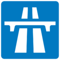
A green or blue symbol like this appears at motorway entry in countries that follow the Vienna Convention.
-
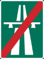
Exits are marked with another symbol.
-
A green or blue symbol like this appears at motorway entry in countries that follow the Vienna Convention.
-
Exits are marked with another symbol.


See also
 In Spanish: Autopista para niños
