
Helsinki facts for kids
Quick facts for kids
Helsinki
Helsingfors (Swedish)
|
|||
|---|---|---|---|
| Helsingin kaupunki Helsingfors stad City of Helsinki |
|||
|
View of central Helsinki along the Mannerheimintie
Sanoma building and Kiasma
Parliament House
Helsinki Cathedral
Beaches at Aurinkolahti
|
|||
|
|||
| Nicknames:
Stadi (by city dwellers), Hesa (by country people), the Daughter of the Baltic, the Pearl of the Baltic Sea
|
|||

|
|||

Helsinki
Location in Europe

Helsinki
Location in Finland
|
|||
| Country | |||
| Region | |||
| Sub-region | Helsinki sub-region | ||
| Metropolitan area | Greater Helsinki | ||
| Charter | 12 June 1550 | ||
| Capital city | 8 April 1812 | ||
| Area
(2018-01-01)
|
|||
| • Capital city | 715.48 km2 (276.25 sq mi) | ||
| • Land | 214.42 km2 (82.79 sq mi) | ||
| • Water | 501.74 km2 (193.72 sq mi) | ||
| • Urban | 680.12 km2 (262.60 sq mi) | ||
| • Metro | 3,698.99 km2 (1,428.19 sq mi) | ||
| Elevation | 26 m (85 ft) | ||
| Population
(2023-12-31)
|
|||
| • Capital city | 674,500 | ||
| • Rank | Largest in Finland | ||
| • Density | 3,145.7/km2 (8,147/sq mi) | ||
| • Urban | 1,360,075 | ||
| • Urban density | 1,999.757/km2 (5,179.35/sq mi) | ||
| • Metro | 1,582,452 (Greater Helsinki) | ||
| • Metro density | 427.8/km2 (1,108/sq mi) | ||
| Demonym(s) | helsinkiläinen (Finnish) helsingforsare (Swedish) Helsinkian (English) |
||
| Population by native language | |||
| • Finnish | 75% (official) | ||
| • Swedish | 5.5% (official) | ||
| • Others | 19.6% | ||
| Population by age | |||
| • 0 to 14 | 14.3% | ||
| • 15 to 64 | 68.3% | ||
| • 65 or older | 17.4% | ||
| Time zone | UTC+02:00 (EET) | ||
| • Summer (DST) | UTC+03:00 (EEST) | ||
| Area code(s) | +358-9 | ||
| Climate | Dfb | ||
.jpg)
.jpg)


Helsinki (hel-SINK-ee) is the capital and largest city in Finland. It is located on the coast of the Gulf of Finland. Helsinki is the center of the Uusimaa region in southern Finland. About 0.67 million people live in Helsinki. The wider metropolitan area has about 1.58 million people.
Helsinki is Finland's most important city for politics, education, money, culture, and research. It is about 80 kilometres (50 mi) north of Tallinn, Estonia. It is also 400 kilometres (250 mi) east of Stockholm, Sweden, and 300 kilometres (190 mi) west of Saint Petersburg, Russia. Helsinki has strong historical links with these cities.
Helsinki, along with Espoo, Vantaa, and Kauniainen, forms the Helsinki metropolitan area. This area is Finland's only large city area. It is also the world's northernmost metropolitan area with over one million people. Helsinki is the northernmost capital city in the EU. The Helsinki Airport in Vantaa connects the city to many places around the world.
Helsinki is a bilingual city. Both Finnish and Swedish are official languages. Most people speak Finnish. A smaller number speak Swedish. Many also speak other languages.
Helsinki has hosted many big events. These include the 1952 Summer Olympics and the Eurovision Song Contest 2007. It was also the World Design Capital in 2012.
Helsinki is known for its high quality of life. Magazines like Monocle and Time have called it one of the best cities to live in. It is also a major tourist city. In 2017, it was the world's busiest passenger port.
Contents
- Understanding Helsinki's Name
- Helsinki's Past: A Brief History
- Helsinki's Landscape and Design
- Helsinki's Buildings and Art
- People of Helsinki
- Helsinki's Economy
- Learning in Helsinki
- Helsinki's Culture and Arts
- Sports in Helsinki
- Getting Around Helsinki
- Helsinki's Global Connections
- Famous People from Helsinki
- Images for kids
- See also
Understanding Helsinki's Name
The name Helsinki comes from the Vantaa River. Early settlers from Sweden called the river Helsingå. This means 'Helsinge River'. This name led to the village and church names in the 1300s. Another idea is that helsing means 'neck'. This could refer to a narrow part of the river with rapids. Other cities like Helsingør and Helsingborg have similar names.
When the town was founded in 1548, it was called Helsinge fors. This means 'Helsinge rapids'. The rapids are at the mouth of the Vantaa River. The city was often called Helsinge or Helsing. This is where the modern Finnish name Helsinki comes from.
Since 1819, official Finnish documents have used the name Helsinki. This happened when the government moved to the city. In local slang, Helsinki is called Stadi or Hesa.
Helsinki's Past: A Brief History


Early Settlements and Trade
People first arrived in the Helsinki area around 5000 BC, after the Ice Age. Permanent settlements began around 1000 AD. These were the Tavastians, who fished and hunted. By the 14th century, there were farming villages.
The area became part of the Swedish kingdom. Trade across the Baltic Sea was important. Helsinki became a key trading center. People exported furs, timber, and fish. They imported salt and grain. This trade made the area wealthy. People in Helsinki could speak several languages, like Finnish, Swedish, Latin, and Low German.
Founding and Growth of the City
King Gustav I of Sweden founded Helsinki on June 12, 1550. He wanted it to be a trading town. He hoped it would compete with Tallinn. The first location was not good for a harbor. So, in 1640, the town moved to the Vironniemi peninsula. This is where the Senate Square and Helsinki Cathedral are today.
For a long time, Helsinki was a small town. It suffered from fires, wars, and diseases. The plague in 1710 killed many people. In 1713, the Swedes burned parts of the town when the Russians attacked.
The Sveaborg fortress was built in the 18th century. This helped Helsinki's importance grow. But the city truly began to develop after 1809. This was when Russia took over Finland and made it the Grand Duchy of Finland.
In 1812, Emperor Alexander I of Russia moved Finland's capital from Turku to Helsinki. This made Helsinki more important. After a big fire in Turku in 1827, the country's only university also moved to Helsinki. This university became the University of Helsinki. The city center was rebuilt in a neoclassical style, looking like Saint Petersburg. This was largely planned by architect C. L. Engel. New technologies like railways also helped the city grow.
Helsinki in the 20th Century
By the 1910s, Helsinki had over 100,000 people. The city kept growing, even through tough times. These included the Finnish Civil War and the Winter War. In the early 1900s, Finnish and Swedish speakers were about equal in number. The local Helsinki slang developed as a mix of Finnish and Swedish.
A major event was the 1952 Summer Olympics. Finland became more urban in the 1970s. This caused the population of the metropolitan area to triple. The Helsinki Metro subway system was also built.
Helsinki's Landscape and Design

Helsinki is known as the "Daughter of the Baltic." It is located on a peninsula and 315 islands. The city center is on a southern peninsula called Helsinginniemi. Some parts of downtown Helsinki are very crowded. But outside the center, there are many suburbs with forests in between.
Helsinki Central Park is a long, narrow park. It stretches from the city center to the northern border. It is a popular place for people to relax. Helsinki also has many boat moorings and marine fishing waters. About 60 types of fish live here.
Important islands include Seurasaari, Lauttasaari, and Korkeasaari. Korkeasaari is home to Finland's largest zoo. The historic fortress island of Suomenlinna is also very special. Helsinki has 60 nature reserves. The largest is the Vanhankaupunginselkä. Helsinki's official plant is the Norway maple. Its official animal is the red squirrel.
Helsinki's Metropolitan Area


The Helsinki capital region includes Helsinki, Espoo, Vantaa, and Kauniainen. This area is Finland's only metropolis. It has about 1.25 million people. It is the most crowded area in Finland.
Greater Helsinki includes the capital region and ten other towns. This larger area has about 1.58 million people. This is about a quarter of Finland's total population. It is the world's northernmost urban area with over one million people.
Helsinki's Climate
Helsinki has a humid continental climate. This means it has warm summers and cold winters. But the Baltic Sea makes winters milder than in northern Finland. Temperatures in January and February are usually around −4 °C (25 °F). Very cold temperatures below −20 °C (−4 °F) happen only a few times a year.
In winter, days are short, with only about 5 hours and 48 minutes of daylight. In summer, days are very long. During the summer solstice, days last almost 19 hours. The average high temperature from June to August is around 19 to 22 °C (66 to 72 °F). The highest temperature ever recorded was 33.2 °C (91.8 °F) in July 2019. The lowest was −34.3 °C (−29.7 °F) in January 1987. Thunderstorms are most common in the summer.
City Districts and Areas

Helsinki is divided into three main areas. These are Helsinki Downtown, North Helsinki, and East Helsinki. Helsinki Downtown is the main core of the city. Other important centers outside downtown include Malmi in the northeast and Itäkeskus in the east.
Helsinki's Buildings and Art


Neoclassical and Romantic Buildings
Carl Ludvig Engel designed many neoclassical buildings in Helsinki. The most important area is the Senate Square. It is surrounded by the Government Palace, the University of Helsinki main building, and the large Helsinki Cathedral. The cathedral was finished in 1852. Helsinki is sometimes called "The White City of the North" because of these buildings. The oldest building in central Helsinki is the Sederholm House (1757).
Helsinki also has many Art Nouveau (Jugend) buildings. These were designed in the early 20th century. They were inspired by Finnish stories like the Kalevala. Architect Eliel Saarinen designed the famous Helsinki Central Station in this style.
Modern Architecture and Skyscrapers

Helsinki has buildings by Alvar Aalto, a famous Finnish architect. He was a pioneer of functionalism. Other functionalist buildings include the Olympic Stadium and the Tennis Palace. These sports venues were built for the 1940 Helsinki Olympic Games. They were used for the 1952 Summer Olympics instead.
In recent years, Helsinki has started building skyscrapers. In Kalasatama, several tall residential towers have been built. The 134 m (440 ft) Majakka is currently Finland's tallest building. Many more high-rise buildings are planned for Helsinki in the 2020s.
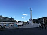
Statues and Sculptures in the City

Helsinki has many famous statues and monuments. These include the statue of Tsar Alexander II of Russia (1894) in Senate Square. Another well-known one is the Havis Amanda fountain sculpture (1908). The Sibelius Monument (1967) is also very popular.
People of Helsinki
| Year | Population |
|---|---|
| 1980 |
483,036
|
| 1985 |
485,795
|
| 1990 |
492,795
|
| 1995 |
525,031
|
| 2000 |
555,474
|
| 2005 |
560,905
|
| 2010 |
588,549
|
| 2015 |
628,208
|
| 2020 |
656,920
|
Helsinki has 674,500 people. This makes it the most populated city in Finland. It is also the third largest in the Nordics. The Greater Helsinki region has about 1.6 million people. About 12% of Finland's population lives in Helsinki.
More women live in Helsinki than men. Helsinki is the most densely populated city in Finland. Life expectancy is slightly lower than the national average.
Helsinki has grown a lot since the 1810s. After World War II, many people moved from the countryside to Helsinki. This caused the city's population to almost double between 1944 and 1969.
In the 1960s, people started moving to nearby cities like Espoo and Vantaa. This was because of a lack of housing in Helsinki. These cities then grew very quickly. This led to better cooperation in public transport and waste management.
Languages Spoken in Helsinki
Population by mother tongue (2022) Finnish (76.1%) Swedish (5.5%) Russian (3.1%) Somali (2.0%) Estonian (1.5%) Arabic (1.5%) English (1.3%) Other (9.0%)
Helsinki is officially bilingual. Both Finnish and Swedish are official languages. In 2022, most people (76.1%) spoke Finnish as their first language. About 5.5% spoke Swedish. About 18.3% spoke other languages. Many people also know English because it is taught in schools.
The local Helsinki slang is a mix of Finnish and Swedish. It also has influences from Russian and German. Today, it has a strong English influence.
Immigration and Diversity
| Population by country of birth (2022) | ||
| Nationality | Population | % |
|---|---|---|
| 555,109 | 83.6 | |
| 13,533 | 2.0 | |
| 10,400 | 1.6 | |
| 6,883 | 1.0 | |
| 5,818 | 0.9 | |
| 3,975 | 0.6 | |
| 3,876 | 0.6 | |
| 3,562 | 0.5 | |
| 2,672 | 0.4 | |
| 2,433 | 0.4 | |
| 2,370 | 0.4 | |
| Other | 53,397 | 8.0 |
In 2022, about 18.6% of Helsinki's population had an immigrant background. This is twice the national average. Helsinki is a major entry point to Finland. This means more people from other countries are moving there.
Most foreign-born residents come from the former Soviet Union, Estonia, Somalia, Iraq, and Russia. Today, at least 160 different languages are spoken in Helsinki. The most common foreign languages are Russian, Somali, Estonian, and Arabic.
Religion in Helsinki
In 2022, the Evangelical Lutheran Church was the largest religious group. It included 47.6% of Helsinki's people. About 47.9% of the population had no religious affiliation. Other religious groups made up 4.5%.
Important churches in Helsinki include Helsinki Cathedral (1852) and Uspenski Cathedral (1868). The Temppeliaukio Church (1969) is also very famous.

There are about 30 mosques in the Helsinki area. Many different groups have their own mosques. The largest is the Helsinki Islamic Center.
The main synagogue in Helsinki is the Helsinki Synagogue from 1906. It is located in Kamppi. It has over 1,200 members. It is one of the oldest synagogues in Finland.
Helsinki's Economy

The Greater Helsinki area creates about one-third of Finland's total economic output. The average income per person here is higher than the national average. Helsinki's economy relies on IT services and public sectors. Shipping companies also employ many people.
Many of Finland's largest companies have their main offices in Greater Helsinki. The city's tap water is very good. It comes from the 120 km (75 mi) Päijänne Water Tunnel. This is one of the world's longest rock tunnels.
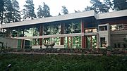
Learning in Helsinki
.jpg)

Helsinki has many schools. There are 190 comprehensive schools and 41 upper secondary schools. It also has 15 vocational institutes. Half of the upper secondary schools are private or state-owned.
Helsinki has two main research universities: the University of Helsinki and Aalto University. There are also many other higher education institutions. These focus on professional education.
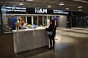
Helsinki's Culture and Arts
Museums to Explore
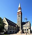
The National Museum of Finland is Helsinki's biggest historical museum. It shows Finnish history from ancient times to today. The museum building itself looks like a medieval castle. The Helsinki City Museum teaches about Helsinki's 500-year history. The University of Helsinki also has several museums.
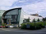
The Finnish National Gallery has three museums:
- Ateneum Art Museum for classic Finnish art.
- Sinebrychoff Art Museum for classic European art.
- Kiasma Art Museum for modern art.
The Design Museum shows Finnish and foreign design. Other museums include the Military Museum of Finland and the Amos Rex Art Museum.
- Museums in Helsinki
-
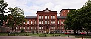
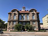
Sinebrychoff Art Museum (1842)
-
Helsinki University Museum "Arppeanum" (1869)
-
The Cygnaeus Gallery Museum (1870)
-
The Mannerheim Museum (1874; 1957 as museum)
-
The Military Museum of Finland (1881)
-
Classical art museum Ateneum (1887)
-
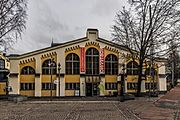
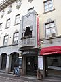
The Design Museum (1894)
-
Tram Museum (Ratikkamuseo) (1900)
-
The National Museum of Finland (1910)
-
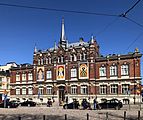
The Helsinki City Museum (1911)
-
The Finnish Museum of Natural History (1913)
-
Kunsthalle Helsinki art venue (1928)
-
Didrichsen Art Museum (1964)
-
Helsinki Art Museum (1968)
-
Kiasma museum of contemporary art (1998)
-
Amos Rex art museum (2018)


Theatres and Music Scene

Helsinki has three main theatres: The Finnish National Theatre, the Helsinki City Theatre, and the Swedish Theatre.
The city is home to two symphony orchestras. These are the Helsinki Philharmonic Orchestra and the Finnish Radio Symphony Orchestra. Both perform at the Helsinki Music Centre. Many famous composers and musicians were born in Helsinki. The Finnish National Opera is also located here.
Many popular bands come from Helsinki. These include Nightwish, Children of Bodom, and HIM. The biggest metal music event is the Tuska Open Air Metal Festival.
Art and Design Events

The Helsinki Day is celebrated every June 12th. It has many fun events and a concert. The Helsinki Festival is an annual arts and culture festival in August.
Helsinki was the World Design Capital in 2012. This recognized how the city uses design for social, cultural, and economic growth. Helsinki is known for its "Embedded Design." This links design to new ideas and global brands.
Helsinki also hosts many film festivals. The Helsinki International Film Festival shows a wide range of films. Night Visions focuses on horror and fantasy movies.
Media and News

Helsinki is a center for media in Finland. There are many newspapers, magazines, and radio stations. Sanoma publishes Finland's main newspaper, Helsingin Sanomat. They also publish the tabloid Ilta-Sanomat.
Finland's national public broadcaster, Yle, has five TV channels and thirteen radio channels. Yle is based in Pasila. The Yle Transmission Tower is a famous landmark in Helsinki. You can sometimes see Tallinn from its top.
Food Culture in Helsinki


Helsinki is a major port city. It is known for its fish food. The Market Square has a traditional herring market since 1743. Salmon is also a popular fish dish.

Helsinki's food scene is growing. It has many different types of restaurants. Asian restaurants like Chinese, Thai, Indian, and Vietnamese are popular. Sushi buffets are also common. There are also restaurants that serve pure Nordic flavors. The Teurastamo area is a popular food spot.
A fun food event called Restaurant Day (Ravintolapäivä) started in Helsinki. It is a day for people to share new food experiences.
Other Cultural Events
.jpg)
Vappu is a yearly carnival for students and workers on May 1st. The Helsinki Pride human rights event takes place in late June.
Sports in Helsinki


Helsinki has a long history with sports. It gained international fame during the 1952 Summer Olympics. The city has also hosted the World Championships in Athletics in 1983 and 2005.
Helsinki has successful teams in football and ice hockey. HJK Helsinki is Finland's largest football club. HIFK and Jokerit are popular ice hockey teams. The Helsinki Olympic Stadium hosted the first Bandy World Championship in 1957.
The Helsinki City Marathon has been held every year since 1981. Helsinki also hosted the European Figure Skating Championships in 2009 and the World Figure Skating Championships in 2017.
The city's sports office manages many sports venues. These include 70 sports halls and about 350 sports fields. There are nine ice rinks and seven artificial ice rinks in winter. People can swim in 14 swimming pools and over 20 beaches. Hietaniemi Beach is very famous.
Getting Around Helsinki
Roads and Highways

Helsinki's main road network has three semicircular beltways: Ring I, Ring II, and Ring III. These connect to highways leading to other parts of Finland. Important highways include:
- Finnish national road 1/E18 (to Turku)
- Finnish national road 3/E12 (to Tampere)
- Finnish national road 4/E75 (to Oulu)
- Finnish national road 7/E18 (to Kotka)

Helsinki has fewer cars per person compared to other similar cities.
Train Travel

The Helsinki Central Railway Station is the main train station in Finland. Trains go north to Tampere and west to Turku. The first railway line in Finland opened in 1862 between Helsinki and Hämeenlinna.
Most long-distance passenger trains in Finland start or end at Helsinki. All major Finnish cities are connected to Helsinki by train.
There is a plan for a Helsinki to Tallinn Tunnel. This train tunnel would connect Helsinki to Tallinn in Estonia. This would link Helsinki to the rest of Europe by train.
Air Travel
Air travel mainly uses Helsinki Airport. It is about 17 kilometres (11 mi) north of Helsinki's downtown. It is located in the nearby city of Vantaa. Helsinki also has Helsinki-Malmi Airport, used for smaller planes.
Sea Travel
.jpg)
Helsinki was built by the sea to use shipping. Even in winter, icebreakers keep the sea routes open. Regular ferry services to Stockholm, Tallinn, and Saint Petersburg started in 1837. Over 300 cruise ships visit Helsinki each year. In 2017, the Port of Helsinki became the world's busiest passenger port.
Ferry connections to Tallinn, Mariehamn, and Stockholm are available. There is also a popular ferry to Porvoo, Finland's second oldest city.
City Public Transport


Public transportation in Helsinki is managed by the Helsinki Regional Transport Authority. The system includes:
Helsinki's tram system started in 1891 with horse-drawn trams. It was electrified in 1900. The system has 14 routes. There is also a new light rail line. The tram network is planned to double in size in the coming years.
The commuter train system started in 1969. It has 15 different services. The trains run frequently, every 10 minutes during busy times. The Ring Rail Line connects to Helsinki Airport.
Helsinki's Global Connections


Helsinki has many international connections. It has an official sister city, Beijing, China. It also has special partnerships with:
Famous People from Helsinki
Born Before 1900


- Karl Fazer (1866–1932), a famous baker and chocolatier who started the Fazer company.
- Oskar Merikanto (1868–1924), a well-known composer.
- Artturi Ilmari Virtanen (1895–1973), a chemist who won the Nobel Prize in 1945.
- Rolf Nevanlinna (1895–1980), a famous mathematician.
Born After 1900


- Tove Jansson (1914–2001), a famous Finnish-Swedish writer and artist, creator of the Moomins.
- Tarja Halonen (born 1943), the 11th President of Finland.
- Aki Kaurismäki (born 1957), a well-known film director.
- Esa-Pekka Salonen (born 1958), a celebrated composer and conductor.
- Linus Torvalds (born 1969), the software engineer who created the Linux operating system kernel.
- Teemu Selänne (born 1970), a Hall of Fame ice hockey player.
- Sam Lake (born 1970), a writer and creative director for video games like Max Payne.
- Ville Valo (born 1976), the lead singer of the rock band HIM.
- Tuomas Holopainen (born 1976), songwriter and multi-instrumentalist for the band Nightwish.
- Lauri Ylönen (born 1979), the lead singer of the rock band The Rasmus.
Images for kids
-
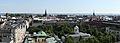
A panoramic view over the southernmost districts of Helsinki from Hotel Torni. The Helsinki Old Church and its surrounding park are seen in the foreground, while the towers of St. John's Church (near centre) and Mikael Agricola Church (right) can be seen in the middle distance, backdropped by the Gulf of Finland.
See also
 In Spanish: Helsinki para niños
- Greater Helsinki
- Helsinki urban area
- Subdivisions of Helsinki
- Underground Helsinki
