
Ontario Highway 401 facts for kids
Quick facts for kids
|
||||
|---|---|---|---|---|
| Macdonald–Cartier Freeway | ||||

Highway 401 within Ontario, Canada
|
||||
| Route information | ||||
| Maintained by the Ministry of Transportation of Ontario | ||||
| Length | 817.9 km (508.2 mi) | |||
| History |
|
|||
| Major junctions | ||||
| West end | ||||
|
||||
| East end | ||||
| Location | ||||
| Major cities: | Windsor, London, Kitchener, Mississauga, Toronto, Oshawa, Kingston and Cornwall | |||
| Highway system | ||||
|
||||


The Ontario Highway 401, also known as King's Highway 401, is a very important road in southern Ontario, Canada. It's like a super-long main street, stretching for about 818 kilometres (508 miles)! This highway connects many major cities across Ontario.
It starts way out west in Windsor. From there, it goes all the way to Ontario's border with Quebec. Once it crosses into Quebec, the road changes its name to Quebec Autoroute 20.
Building this huge highway began in 1947. By 1952, some parts were ready for cars. All the different sections were finally connected by 1964, making it one long road. More recently, in 2013, work started to extend the highway even further. This new part will reach the Gordie Howe International Bridge near Detroit, connecting Canada and the U.S.
In 2008, a special part of the highway got a new name: the "Highway of Heroes." This section is between Trenton and Toronto. It was named to honour Canadian soldiers who lost their lives while serving overseas. Their bodies are brought back to the Trenton air force base. From there, they are respectfully transported along this highway to Toronto.
Contents
Exploring Highway 401
Highway 401 is one of the busiest roads in North America. It helps people and goods travel across Ontario. This makes it a very important part of Canada's economy.
How Long is Highway 401?
The highway is about 817.9 kilometres (508.2 miles) long. That's a really long drive! It takes many hours to travel from one end to the other.
Where Does it Go?
The highway connects many big cities in Ontario. It starts in Windsor in the west. Then it passes through cities like London, Kitchener, Mississauga, and Toronto. It continues east through Oshawa, Kingston, and Cornwall. Finally, it reaches the Quebec border.
Building the Highway
Work on Highway 401 began in 1947. It was a huge project that took many years to finish. Different parts of the highway were opened at different times.
Early Construction
By 1952, three main sections of the highway were open. These parts were not all connected yet. It took until 1964 for all the pieces to link up. This created the long highway we know today.
Connecting to the U.S.
In 2013, a new project started in Windsor. This project is extending Highway 401 to connect with the Gordie Howe International Bridge. This bridge will make it easier for people and goods to travel between Canada and the United States.
The Highway of Heroes
A special part of Highway 401 is known as the "Highway of Heroes." This section runs between Trenton and Toronto. It received this name in 2008.
Honoring Fallen Soldiers
When Canadian soldiers are killed overseas, their bodies are flown back to the air force base in Trenton. From there, they are driven along Highway 401 to Toronto. People often gather on overpasses to pay their respects as the procession passes by. This is a way for Canadians to show their gratitude and sadness for the soldiers' sacrifice.
Images for kids
-
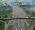
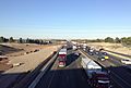
The widest part of Highway 401 is near Toronto Pearson International Airport. It has 18 lanes for traffic!
-
Highway 401 gets wider to six lanes near Highway 402 in London.
-
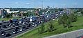
Over 500,000 vehicles use Highway 401 at Weston Road every day in the summer.
-
Signs on Highway 401 use different colours to help drivers. Green signs are for express lanes, and blue signs are for collector lanes.
-
"The Basketweave" is a special section east of Highway 400. It helps cars move smoothly between collector and express lanes.
-
Highway 401 looking west from the Don Mills Road overpass. You can see buildings like Concord Park Place and North York General Hospital.
-

Highway 401 just west of Leslie Street.
-
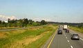
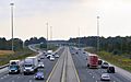
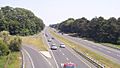
In eastern Ontario, Highway 401 is a rural freeway. It has a grassy area in the middle called a median.
-
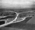
The Thousand Islands Parkway (Highway 2S) was being built in 1944.
-
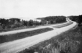
The old Highway 2A near Highland Creek looks much like it did when it opened in 1947.
-
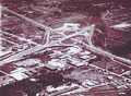
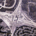
The Highway 400 interchange in 1953. Today, it's a modern, multi-level interchange.
-
Soon after opening, the Toronto Bypass was very busy. It was widened to 12 lanes starting in 1963.
-
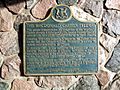
A plaque near Brockville celebrates the official completion of the highway on October 11, 1968.
-
Widening Highway 401 in Toronto took nine years. At least four lanes were always open during construction. This photo shows the Highway 401 / Don Valley Parkway / Highway 404 interchange being built in 1965.
-
Highway 401 at Meadowvale Road in 1989, before it was widened to 14 lanes.
-
Highway 401 facing southwest in 1958, near the interchange with old Highway 98.
-
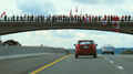
Canadians stand on overpasses along the Highway of Heroes to honour fallen soldiers.
-
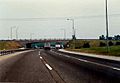
Highway 401 was widened in 2008 between Highway 402 and Wellington Road in London.
-
An empty Highway 401 in Toronto after propane explosions in 2008.
-
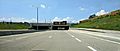
The Highway 401 extension in Windsor, opened in 2015. It's a six-lane road with tunnels.
-
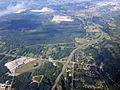
Highway 401 in the Greenbelt, near the Guelph Line interchange. This part will be widened to ten lanes.
-
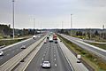
Work to widen Highway 401 in Mississauga, seen from Mississauga Road in 2020.
-
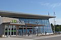
The ONroute Cambridge South service station.
-
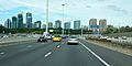
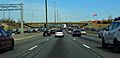
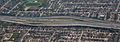
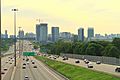
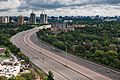
Highway 401 looking east between Avenue Road and Yonge Street. You can see the North York skyline.
-
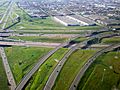
Highway 401 at the interchange with Highway 410 and Highway 403 in Mississauga.
-
Traffic cameras are placed at every exit in Toronto. They are part of the COMPASS system.
-
The collector-express system just east of the Highway 400 interchange. You can see the "Basketweave" transfers in the background.
-
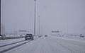
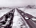
Winter weather conditions on Highway 401 in Toronto during a snowsquall.


.jpg)


