
Ontario Highway 402 facts for kids
Quick facts for kids
|
||||
|---|---|---|---|---|

Highway 402 highlighted in red
|
||||
| Route information | ||||
| Length | 102.5 km (63.7 mi) | |||
| History | Planned: 1938 Designated: 1953 Completed: 1982 |
|||
| Major junctions | ||||
| West end | ||||
| East end | ||||
| Location | ||||
| Counties: | Lambton, Middlesex | |||
| Major cities: | Sarnia, London | |||
| Highway system | ||||
|
||||

Ontario Highway 402, also called King's Highway 402, is an important road in southwestern Ontario, Canada. It helps people travel between the Blue Water Bridge in Sarnia and Ontario Highway 401 in London. This highway mainly runs from west to east. The town of Strathroy-Caradoc is the only large community directly along its path.
Contents
Exploring Highway 402
Highway 402 is a special kind of road called a provincial highway. This means it is managed by the province of Ontario. It is part of a group of major highways known as the 400-series. These roads are designed for fast and safe travel.
How Highway 402 Was Built
The idea for Highway 402 began a long time ago. Planning for the road started in 1938. Construction on the highway first began in 1939. However, work had to stop because of World War II.
Building the highway started again in 1952. It took many years to complete the entire road. The highway was finally finished in 1982. This made it much easier to travel between Sarnia and London.
Modern Updates to the Highway
Over the years, Highway 402 has been improved. In 2009, a section of the highway near Sarnia was made wider. This part of the road was expanded from four lanes to six lanes. Making the highway wider helps more cars travel smoothly. It also reduces traffic jams, especially near the busy border crossing.
Images for kids
-
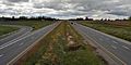
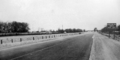
Highway 402 has a wide grass median separating the carriageways for the majority of its length.
-
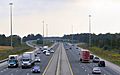
The eastern terminus of Highway 402 with Highway 401 in London
-
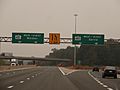
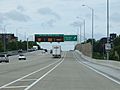
The start of Highway 402 westbound as it splits off from Highway 401.
-
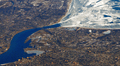
Aerial view of Highway 402 passing through Sarnia; the Blue Water Bridge is visible. Lake Huron, to the upper right, is largely covered in ice.
-
Highway 402 facing east towards the Modeland Road intersection in 1959. In the distance beyond the intersection, the two carriageways converge into Highway 7. This intersection was reconstructed as an interchange by 1963, but then bypassed by a new alignment of Highway 402 in the 1970s.
-
Highway 402 westbound in Sarnia; lanes are separated to split local traffic from international/NEXUS traffic bound for the Blue Water Bridge. This allows the highway to function locally during long border delays.


.jpg)


