Ontario Highway 400 facts for kids
Quick facts for kids
Highway 400 |
||||
|---|---|---|---|---|
| Toronto–Barrie Highway | ||||
 |
||||
| Route information | ||||
| Length | 226 km (140 mi) | |||
| History | Opened December 1, 1951 – July 1, 1952 |
|||
| Major junctions | ||||
| South end | Maple Leaf Drive – Toronto (continues as Black Creek Drive) |
|||
| North end | ||||
| Location | ||||
| Major cities: | Toronto Barrie Sudbury (future) |
|||
| Towns: | Parry Sound, Bradford, King | |||
| Highway system | ||||
|
||||
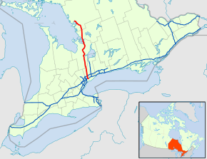
Ontario Highway 400, also known as King's Highway 400, is a very important road in Ontario, Canada. It is a long highway that runs mostly north and south. This road is about 226 kilometers (140 miles) long. It connects the big city of Toronto in the south to Carling in the north.
Contents
What is Highway 400?
Highway 400 is part of Ontario's special "400-series" highways. These roads are like superhighways. They are designed for fast and smooth travel. They help people and goods move quickly across the province. Highway 400 is one of the busiest roads in Ontario.
A Busy Road
This highway is a vital link for many communities. It helps people travel for work, school, and fun. It also helps trucks carry goods to stores and businesses. Because it's so important, Highway 400 can get very busy. Especially during rush hour or on long weekends.
How It Was Built
Building Highway 400 was a big project. The first parts of the highway opened in the early 1950s. This was between December 1951 and July 1952. It was built to connect Toronto with the cottage country to the north. This made it easier for people to travel to their vacation spots.
Overcoming Challenges
Building a highway this long was not easy. Workers had to clear forests and level land. In some northern areas, they even had to blast through huge granite rocks. These rock cuts are still visible today. They show how much work went into building the road. Some parts of the highway also have rock formations in the middle.
Driving on the 400
Driving on Highway 400 can be an interesting experience. As you drive north, the scenery changes. You'll see busy city areas first. Then, you'll pass through farmlands and small towns. Further north, you'll see more forests and rocky landscapes.
Traffic and Travel Tips
Because Highway 400 is so popular, it often has a lot of traffic. Sometimes, accidents can cause long delays. It's always a good idea to check traffic conditions before you travel. Planning your trip can help you avoid busy times. This way, you can have a smoother journey.
The Future of Highway 400
Highway 400 is still growing. There are plans to extend it even further north. The goal is to connect it to Sudbury in the future. This extension will help more people and goods travel across Ontario. It will make the highway even more important.
Images for kids
-
Interchange of Highway 400 and 401, looking towards the south. The exit ramp to Highway 401 is often congested.
 | Ernest Everett Just |
 | Mary Jackson |
 | Emmett Chappelle |
 | Marie Maynard Daly |


