
Ontario Highway 407 facts for kids
Quick facts for kids
|
||||
|---|---|---|---|---|
|
Highway 407 highlighted in red
|
||||
| Route information | ||||
| Maintained by Province of Ontario 407 ETR Concession Company Limited |
||||
| Length | 151.4 km (94.1 mi) | |||
| History | Proposed 1959–1986, Opened 1997–2001 Extended 2016–2019 |
|||
| Major junctions | ||||
| West end | ||||
|
||||
| East end | ||||
| Highway system | ||||
|
||||

Ontario Highway 407, also known as 407 ETR (Express Toll Route), is a special highway in Ontario, Canada. It runs north of Toronto and is different because it's a privately owned toll road. This means you have to pay to use it.
The highway uses cool camera technology to figure out who is using it. Instead of old-fashioned toll booths, cameras read your licence plate. To make it cheaper and easier, many drivers use a small device called a transponder. This highway is super helpful for avoiding busy traffic on the Ontario Highway 401.
Contents
All About Highway 407
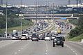
Highway 407 is a major road that helps people travel across the Greater Toronto Area. It stretches for about 151.4 kilometers (about 94 miles). It connects many cities and towns, making travel faster.
How Tolls Work on Highway 407
Since Highway 407 is a toll road, you pay to drive on it. But it's not like old toll roads with booths where you stop.
- Cameras: When you enter or exit the highway, cameras take pictures of your licence plate. The system then knows how far you drove.
- Transponders: Many drivers use a small electronic device called a transponder. This device sits on your car's dashboard. It communicates with sensors on the highway. Using a transponder often makes the tolls cheaper.
- Billing: After your trip, the company sends a bill to the car's owner. This bill shows how much you owe for using the highway.
Why Was Highway 407 Built?
The idea for Highway 407 started a long time ago, in the 1950s. Toronto and the surrounding areas were growing fast. The main highway, Ontario Highway 401, was getting very crowded.
- Traffic Relief: The biggest reason was to help reduce traffic jams on Highway 401. Highway 407 offers another route for drivers.
- Faster Travel: For those willing to pay, Highway 407 provides a quicker way to get around. This is especially true during busy rush hours.
- Private Ownership: Unlike most highways in Ontario, Highway 407 ETR is owned and operated by a private company. This was a new way to build and manage a big road project.
Where Does Highway 407 Go?
Highway 407 stretches across a large part of southern Ontario.
- Western End: It starts in Burlington, where it connects with Ontario Highway 403 and the Queen Elizabeth Way.
- Eastern End: It ends in Clarington, connecting to Ontario Highway 35 and Ontario Highway 115.
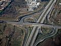
- Major Connections: Along its path, Highway 407 connects with many other important highways. These include Highway 401, Highway 400, and Highway 404. It also connects to newer toll highways, Highway 412 and Highway 418.
Building the Highway
Building a highway this long was a huge project!
- Early Plans: The idea was discussed for many years, from 1959 to 1986.
- Opening in Stages: The first parts of the highway opened in 1997. More sections were added until 2001.
- Extensions: Later, the highway was extended even further east. These extensions opened between 2016 and 2019. This made the highway even longer and more useful.
Images for kids
-
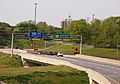
Highway 407 begins at the Highway 403/Queen Elizabeth Way junction in Burlington
-
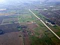
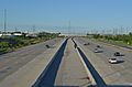
Highway 407 south of Highway 401; this section follows a north–south alignment to Highway 403
-
Highway 407 and Derry Road, facing southwest; this sections of Highway 407 parallels the boundary between Mississauga (at left) and Milton (at right).
-
Highway 407 facing east toward Pine Valley Drive, in Vaughan
-
Highway 407 at Woodbine Avenue
-
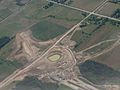
Construction in 2015 of the overpass and off-ramp at Harmony Road in Durham Region, the temporary terminus of the highway from June 20, 2016, until January 2, 2018.
-
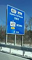
Sign for the transition between 407 ETR and 407 East, two kilometres west of Brock Road in Pickering.
-
Highway 407 shield in Oshawa
-
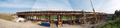
A bridge under construction along Highway 7 west of Brooklin in 2012; this was the first project along the new extension.


