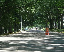
Bronx River Parkway facts for kids
Quick facts for kids
Bronx River Parkway |
|
|---|---|
|
Bronx River Parkway highlighted in red
|
|
| Route information | |
| Maintained by NYSDOT and Westchester County | |
| Length | 19.12 mi (30.77 km) |
| Existed | 1908–present |
| History | Completed in 1952 |
| Tourist routes |
New York State Scenic Byway |
| Restrictions | No commercial vehicles |
| Major junctions | |
| South end | Story Avenue in Soundview |
|
|
| North end | |
| Location | |
| Counties: | Bronx, Westchester |
| Highway system | |
| Numbered highways in New York Interstate • U.S. • N.Y. (former) • Reference • County |
|
The Bronx River Parkway is a special road in New York. It's about 19 miles (31 km) long. This road is named after the Bronx River, which flows right next to it.
The parkway starts in a part of the Bronx called Soundview. It ends in Valhalla, in Westchester County. There, it connects to the Taconic State Parkway. Parts of the parkway are looked after by the New York State Department of Transportation and other parts by Westchester County. Big trucks and commercial vehicles are not allowed on this road.
Contents
Exploring the Bronx River Parkway
The Bronx River Parkway is a major route for people driving in and around New York City. It helps drivers get from one place to another quickly. The parkway also runs through beautiful park areas.
Driving Through The Bronx
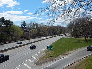
The southern part of the parkway is in the Bronx. It's a busy road for people going to work or school. It crosses paths with several other big roads. As you drive, you'll see basketball courts and baseball fields next to the road.
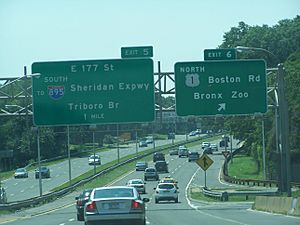
Near West Farms, the parkway connects with the Cross Bronx Expressway (I-95). Further north, the road goes over train tracks. It also passes by the Bronx Zoo and the New York Botanical Garden. These are famous places to visit! The Bronx River itself starts to follow the parkway closely here.
You'll see exits for places like Pelham Parkway and Mosholu Parkway. The parkway then runs next to the Woodlawn Cemetery, which is a very old and important place. As you keep going north, the parkway crosses into Westchester County.
Driving Through Westchester County
Once in Westchester County, the parkway goes through Yonkers. It connects with the Cross County Parkway. This is a big interchange where many cars switch roads.
Further north, near Bronxville, the Sprain Brook Parkway splits off. This helps drivers who want to avoid White Plains. The parkway then becomes more like a park road again. You might see paved bike paths and a pond.
As you get closer to White Plains, the parkway has intersections with traffic lights. This is different from the highway-style exits you saw earlier. White Plains is a big city and the main town in Westchester County. The parkway connects to other important roads here, like NY 100 and NY 119.
The parkway ends at the Kensico Circle in Valhalla. From there, you can get onto the Taconic State Parkway. You can also see the Kensico Dam nearby, which is a huge dam that holds water for New York City.
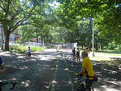
Did you know? A part of the Bronx River Parkway in Westchester County is closed to cars on some Sundays in May, June, and September. This allows people to ride their bikes or inline skate safely on the road!
History of the Parkway
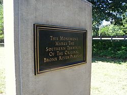
The Bronx River Parkway is very old and important. Construction started in 1907 in Westchester County. This makes it one of the very first roads built just for cars.
The Bronx River Parkway was a pioneer in road design. It was the first highway to have a grassy area in the middle, called a median strip, to separate traffic going in opposite directions. It was also the first highway built through a park. Plus, it was the first road where other streets crossed over it on bridges.
The Westchester section of the parkway opened in 1922 and was finished in 1925. Later, in 1951, a new part of the road opened in the Bronx. From 1953 to 1955, a section of the parkway was closed to make it straighter and wider. This helped make driving safer and smoother.
Over the years, some exits and entrances have been changed to improve traffic flow. For example, some old gas stations along the parkway have been closed or changed. The parkway's design has been studied by experts because it was so innovative for its time.
Exit list
| County | Location | Mile |
Roads intersected | Notes | ||
|---|---|---|---|---|---|---|
| The Bronx | Soundview | 0.00 | 0.00 | 1 | Story Avenue – Soundview Park | Southern terminus |
| 0.2 | 0.32 | 2E | No northbound exit | |||
| 0.3 | 0.48 | 2W | No southbound access to Watson Avenue | |||
| West Farms | 0.5 | 0.80 | 3 | Westchester Avenue | Southbound exit only | |
| 0.7 | 1.1 | – | East 174th Street | Southbound entrance only | ||
| 0.86 | 1.38 | 4 | ||||
| 1.1 | 1.8 | 5 | Southbound exit only | |||
| Bronx Park | 2.23 | 3.59 | 6 | |||
| 2.40 | 3.86 | 7 | Signed as exits 7E (Pelham Parkway) and 7W (US 1); west end of Pelham Parkway | |||
| 3.07 | Signed as exits 8E (Allerton) and 8W (Mosholu); south end of Mosholu Parkway | |||||
| Williamsbridge | 3.92 | 6.31 | 9 | Gun Hill Road | ||
| Woodlawn | 5.14 | 8.27 | 10 | East 233rd Street | Also serves Woodlawn station | |
| Westchester | Yonkers | 5.95 | Bronx River Road – Yonkers, Bronx | Southbound exit and entrance | ||
| 6.6 | Yonkers Avenue – Yonkers, Mount Vernon | Northbound exit and entrance | ||||
| 7.0 | Bronx River Road – Yonkers | Southbound exit and entrance | ||||
| 7.28 | Signed as exits 11E (east) and 11W (west) | |||||
| 8.43 | Northbound exit and southbound entrance; southern terminus of the Sprain Parkway | |||||
| 8.5 | Desmond Avenue – Yonkers | Southbound exit and northbound entrance | ||||
| 8.7 | Paxton Avenue – Bronxville | No southbound exit | ||||
| 8.9 | West Pondfield Road – Bronxville, Yonkers | Northbound exit only | ||||
| 9.7 | Elm Street – Tuckahoe | Northbound exit and entrance | ||||
| 9.92 | Scarsdale Road – Crestwood, Tuckahoe | At-grade intersection | ||||
| 10.1 | Read Avenue – Crestwood | No entrance ramps | ||||
| 10.4 | Thompson Street – Crestwood Station | Northbound exit and entrance | ||||
| 10.6 | Vermont Terrace – Crestwood | Southbound exit and entrance | ||||
| 11.15 | Leewood Drive – Crestwood, Eastchester | At-grade intersection except northbound exit | ||||
| 11.87 | Strathmore Road / Harney Road – Scarsdale, Eastchester | At-grade intersection | ||||
| Greenburgh | 12.6 | Ardsley Road – Greenburgh | Southbound exit and entrance | |||
| Scarsdale | 12.88 | Crane Road / East Parkway – Scarsdale | At-grade intersection except northbound exit; no southbound entrance | |||
| 13.3 | Ogden Road – Scarsdale | Northbound exit and entrance | ||||
| 13.8 | Butler Road – Scarsdale | Northbound exit and entrance | ||||
| 14.2 | Fenimore Road / East Hartsdale Avenue – Scarsdale, Hartsdale, Greenburgh | Northbound exit and southbound entrance | ||||
| 14.4 | Greenacres Avenue – Scarsdale | Southbound exit only | ||||
| 15.1 | River Road – Scarsdale | Northbound entrance only | ||||
| 15.2 | Claremont Road – Scarsdale | Northbound at-grade intersection | ||||
| White Plains | 15.46 | Walworth Avenue – White Plains | Northbound at-grade intersection | |||
| 16.06 | Northbound exit and southbound entrance; northbound access to NY 119 is via exit 22; NY 119 not signed | |||||
| 16.4 | Southbound at-grade intersection | |||||
| 16.5 | At-grade intersection | |||||
| Greenburgh | 17.2 | Old Tarrytown Road – Greenburgh | At-grade intersection | |||
| 17.84 | Fisher Lane – North White Plains, Greenburgh | At-grade intersection | ||||
| 18.1 | Parkway Homes Road | At-grade intersection | ||||
| 18.37 | Virginia Road – Greenburgh, Mount Pleasant, North Castle | At-grade intersection | ||||
| North Castle | 18.8 | Lafayette Avenue / Washington Avenue – North Castle | Northbound at-grade intersection | |||
| Valhalla | 18.94 | Southbound access is via Taconic Parkway | ||||
| 18.94 | Continuation beyond Kensico Circle | |||||
| 1.000 mi = 1.609 km; 1.000 km = 0.621 mi | ||||||
 | Dorothy Vaughan |
 | Charles Henry Turner |
 | Hildrus Poindexter |
 | Henry Cecil McBay |


